|
Rockies to the Arctic Ocean
(Three Rivers Expedition)
The Three Rivers Book is available @ $34.00.Three Rivers to Tuktoyaktuk is an almost 4000km journey along the Athabasca, Slave and Mackenzie Rivers in Canada starting from the Rocky Mountains and finishing at the Arctic Ocean. The first part of the journey Tony Chounding and Terry Bolland paddled the Athabasca and Slave Rivers experiencing high mountains, swamps and flat-land, huge rapids, total wilderness, insects, local First Nation people, big lakes and a multitude of wildlife.At Hay River on the Great Slave Lake they met up with Alaine Davin and Leonie Cockman who paddlded the second part of the journey across part of the Great Slave Lake and down the longest river in Canada, the Mackenzie.There were now 2 canoes and 4 different personalities.254 colour photographs, 260 pages and 4 maps. Printed in WA.It’s just not a great story but also a Canadian wilderness colour picture-book.

**********************
Three Rivers to Tuktoyaktuk
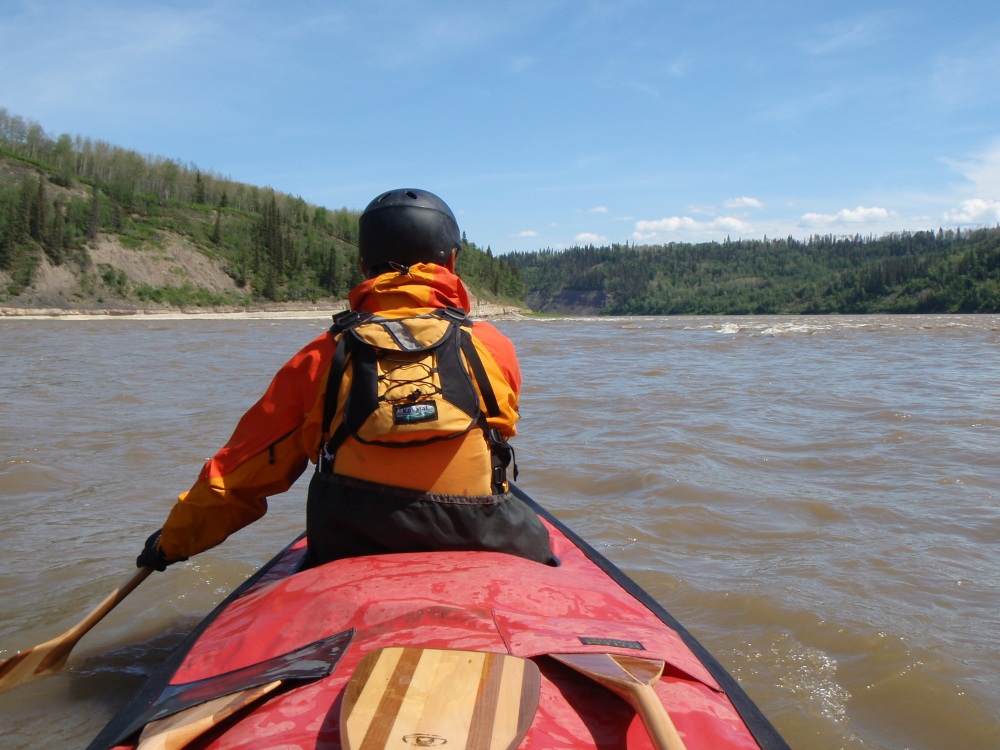
All the big waves were on the left-hand side of the river, so we kept to the right side which appeared to be safer. As we approached Rock Rapid it didn’t look so bad downstream, but as we got closer I could see a bundle of big waves peaking and exploding like an erupting volcano a few hundred metres ahead. Knowing that we were heading for trouble we had no option but to divert and, as it now looked completely calm on the left hand side we started to head over, foregoing the chance of getting out and checking our route.
As we moved across to the left side of the river on a particularly swift current to paddle what appeared to be safe, not turbulent water, our heavy canoe was being whisked away as if it was a cork. By the time we reached the centre, I suddenly noticed that the flat line of water that spanned virtually the whole width of the river was actually a wide ledge and beyond it the river dropped and disappeared into a deep hole. At the bottom of the ledge, and after the deep hole there was a huge high wave waiting. We couldn’t escape to the left side as it was too far, the water too fast and the shore was actually lined by a vertical cliff and worst of all, we had come too far to go back to the safer right shore! The only way forward was straight towards and over the ledge. I looked beyond the ledge and thought shit – bloody hell…..this is a big one, we could be in trouble here.
Over the roar of the rapid I shouted to Tony to straighten up and just go for it. There was nothing else we could do. Our chances of getting through it seemed slim as it was one hell of a drop with a massive wave that followed. Although we could have been looking at death in the eye or at least be subject to a horrific capsize, I didn’t feel any panic or any real fear.
Tony put in two magnificent strong bow draw strokes which brought the bow around, so within seconds we managed to get the canoe straight. We were soon at the top of the ledge with the massive wave dancing wildly before our eyes and I could only think of paddling strongly. We slid at great speed, down what seemed to be a giant water slide. The wave at the bottom was colossal. I shouted to Tony to paddle hard as we have to hit it with speed – oh shit……
As we headed down the ramp and towards the monster wave I expected to be sucked in and spat out. I still had no fear and I don’t know why. Maybe things were happening too fast to sense fear or I just knew there was no turning around, and we had no choice but to deal with the situation. At the bottom of the slide we looked up to see the wall of water towering above us and it really didn’t seem possible to get through it without capsizing. The size of the wave was bigger than anything that I had ever been through before.
What goes down must come up and by hell did we come up. The heavy canoe charged through the wave and Tony got a walloping. For a fraction of a second he was gone, and then the wall of water crashed on me holding me captive for a few seconds under the bubbling aerated mass of water. It took us a while to adjust our vision and see what was ahead as a waterfall of water was cascading down our faces. I was expecting another big wave but the next one was much smaller and we speared through it without a problem. It was an amazing experience! We thought we were going to be gobbled up by the huge roller coaster but somehow we came out of it intact and still upright.
****************************
INTRODUCTION
This expedition was the last in the big four North American rivers that I had planned to paddle. I had already completed the 4000km Mississippi River, the 3400km Yukon River, the 4000km Missouri River and now the focus was on a near 4000km journey down the Athabasca, Slave and MacKenzie Rivers from Jasper in the Canadian Rocky Mountains to Tuktoyaktuk on the shores of the Arctic Ocean.
To take us to the start of this latest journey Ed Jager and his wife Sue Van Allan were waiting patiently at the Vancouver airport. I first met Ed and Sue while competing in a canoe race called the Yukon River Quest on the Yukon River in 2004. Ed was the oldest competitor. Two years later, when I planned on a solo paddle of the Missouri River, Ed offered to drive me hundreds of kilometres to the headwaters of the river, meet me at the halfway mark and then meet me at the end of the trip. I couldn’t have asked for any better assistance. Now he and Sue were here again to help me out.
As we crossed the Rocky Mountains and got close to our destination we passed moose, bear and a number of other animals roaming the roads. The mountains were topped with snow and the rivers were raging and swirling with white water. We reached the town of Jasper. Although it was striking, I had, for whatever reason, expected something more special. Although the longer I was there, the more I began to appreciate it.
Thursday 5th June 2008
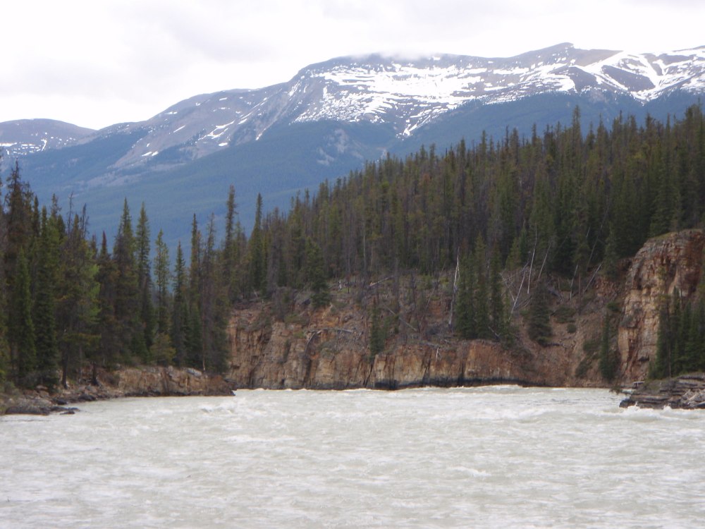
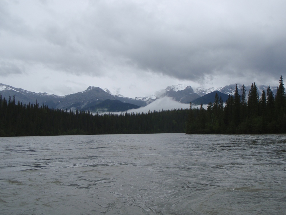
It was the day of reckoning. Our plan was to drive upstream of Jasper and launch our canoe on the Athabasca River below the Athabasca Falls and paddle back to Jasper with an unloaded canoe as a test run. The scenery was stunning on the way there and when Ed parked along the roadside near the falls we walked about 300 metres down a track to the river.
The river was running swiftly and the mountain tops were white and heavily laced with mist. Rain clouds moved across the sky in bands, occasionally lifting and allowing the snow trails that were leading down the mountain ravines and petering out on the lower slopes to become visible. Across the river, the green spruce trees stood tall and dominant.
Immediately before us were rapids, raging white water and drops, vertical cliffs and a narrow canyon. There was a rock island sitting in the middle of the river and as we walked along the river’s edge trying to get a better view of the white water downstream, it became obvious that it was impossible to see around the canyon bend.
I paused. We were just about to start our 4000km canoeing trip to the Arctic Ocean and we had to make a decision if we should depart at this point or not! My adventurous spirit egged me on. It would be such an adrenalin rush to paddle down the rapids through the canyon door and be spat out into the open vista of the stunning Jasper National Park, but deciding between wanting an adrenalin rush, or allowing common sense to prevail had me with mixed emotions.
From the rocks, I stood and looked intently at a huge wave crossing much of the river. It was about halfway down the rapid and approximately 100 metres from where the rock walls narrowed and formed the canyon. At this point there seemed to be more drops, and going by the height of the waves the drops looked big. Where the canyon narrowed, the water hit the rock walls and created a long row of big standing waves that roared and thundered down the canyon and out of sight.
Fallen spruce trees were spread around, and many dangled dangerously on the rock wall above the river. The sparsely snow covered mountain in the background became clear of cloud, but my mind wasn’t. As I stood looking into the canyon I asked myself, did I really want to risk the whole trip by starting from this point when I knew nothing of the difficulty downstream? Were we being reckless to start here or was it part of the adventure? What if we lost the canoe before we started our trip? There was a lot at stake. Alaine and Leonie were meeting us 2000kms downstream at the halfway point and we had to do everything that we could to get there safely.
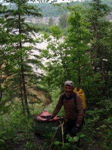
Below Athabasca Falls
I balanced on a boulder and reached my decision. For me common sense had to prevail. I felt it too risky to put in upstream of the canyon not knowing what lay ahead, so with Tony being happy to take my advice we had to find another launching point downstream. We returned to Ed and Sue’s RV passing a group of school children and a few tourists milling around at the water’s edge.
I was disappointed to be heading further downstream, but I was also relieved. We really needed to start our journey safely. Ed started the engine and he drove along a minor road that led north on the west side of the river. A few kilometres downstream we crossed the Whirlpool River and found an easy spot, on the junction of the Whirlpool and Athabasca Rivers to launch our canoe. We were somewhat happier to ease into our journey without any immediate danger.
It was interesting to learn that it was here that the early explorers and fur traders paddled and portaged from one watershed to another. The Whirlpool River, 24 kilometres upstream of Jasper was discovered in the winter of 1810 by David Thompson as a fur trade route. By paddling upstream from this point the Whirlpool River led to the 1737 metre high Athabasca Pass in the Rocky Mountains, where fur traders portaged and then launched their canoes again on the other side of the mountain range and used the rivers on that side to reach Vancouver and the Pacific Ocean.
The canoe was taken off the trailer and placed next to the river. There was a chill in the air but Tony and I donned our thermals and paddling jackets and we were warm. It took only minutes to load our emergency equipment in the canoe, strap on the spray deck and push the canoe out into deeper water. The freezing water seeped into our booties and our senses were shocked by the intense cold, but the cold served as a good reminder and incentive not to capsize on our downstream trip.
It was time to take off. Ed and Sue took photos as we posed near the river bank. Rain suddenly started and lashed us at a 45 degree angle, but it didn’t bother us too much as we were all rugged up, the adrenalin was pumping and we were ready to take on the river. Minutes later we took our first paddle strokes, paddled slightly upstream and then turned to head downstream towards Jasper. This was really it! This was the start of another new adventure.
Our canoe wasn’t loaded as this little excursion was only a test run, a familiarisation. Tony hadn’t paddled a canoe in white water before and we had only paddled a few times in flat water together as we had both been paddling with other paddling partners in training. Therefore because I had paddled extensively on white water in a double and single canoe for over 30 years, and was the more experienced paddler, I took the position in the stern. The stern paddler is responsible for doing a lot of the steering and has more control of the canoe but working as a team was paramount if we wanted to get through the rapids safely. This morning’s paddle was going to be the only chance we would have to practise our white water skills before we took off with a fully laden and much heavier canoe.
We waved to Ed and Sue before being whisked away by the strong current and right into a mass of standing waves. The water lapped over the bow for the first time and a little reached me in the rear, but Tony was getting the freezing cold water in his lap. At the bottom of the rapid we paused with our paddles and drifted and looked towards the mountains. It was hard to believe that we were actually here in the magical Jasper National Park after so many months of planning and looking at pictures on the internet and in glossy travel books.
The mountaintops showed their jagged peaks, then low clouds that were passing over hid them for a while. The water was moving swiftly and although flat one minute, it was running wild and spirited the next. With little weight in the canoe we were able to zip around, enter eddies with ease, move from one side of the river to the other and to be free. Tomorrow would be very different when the canoe would be loaded with all our gear.
We seemed to be working well together as we breezed through grade 2 rapids which gave us no trouble at all. With it being a wide river we were able to skirt most dangers and stop in eddies to take photographs or view the scenery. We reached a bigger rapid, the waves were higher, but it still looked easy. Then from out of the blue a rock was suddenly in our path. With quick evasive action from both of us we sidestepped the rock, but only just! The bow ploughed into the stopper behind the rock, the water swamped Tony’s spray deck and the canoe tilted to one side but we kept it on track. This was a good wakeup call for us both early in the journey. We must never become complacent!

A few kilometres upstream of Jasper
After challenging several grade two rapids and viewing stunning mountain scenes that were truly inspiring we neared the end of our practise run, passing a raft and stopping just beyond the town bridge where Ed and Sue were waiting. As we pulled in we thought the section that we had paddled had been easier than what we were expecting from the literature we had read. We talked to a rafting guide who had been working in Jasper for a year and asked him about the dangers downstream, but he knew nothing of the river beyond this point.
We were quite happy with our day’s paddle and before returning to the campsite we did a little shopping in Jasper and had a meal in a restaurant. It would be our last dining experience for some time.
What a day! This was our first step to being on our own, and although we didn’t really know what was in front of us, we did know it was going to be a great adventure with big rapids, huge lakes, annoying mosquitoes, the constant threat of bears and 4000kms of pain and strain.
Day 1 – Friday 6th June – The Expedition Begins
At breakfast Sue made delicious muffins, coffee and juice. The park abounded with squirrels, there were elk grazing in a meadow and ravens were rummaging around. But it was time to leave this beautiful campground and head for the river for the real start of our epic journey.
At the river we unpacked our gear from the vehicle and lifted the canoe to the water’s edge where we started loading it. Towards the west, beyond the spruce trees, mist was covering the snow covered mountain tops. It was cool and cloudy and light rain was falling, but we were warm, rugged up in our thermals and Gore-Tex jackets.
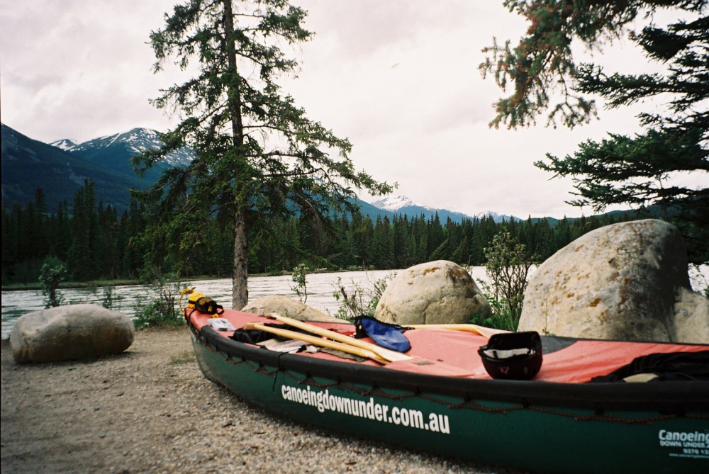
Ready to load for the 4000km expedition
The canoe began to look a little overloaded. I felt disorganised and a little embarrassed as we placed, pushed and fumbled to squeeze things into any vacant gap. Although we had practised loading beforehand it was now like a jigsaw with too many pieces that wouldn’t fit into place. Thankfully we didn’t have a crowd of people watching as I’m sure they would have thought that we hadn’t done this before.
With cold hands we tied the spray-deck down. Once on, nothing could escape, even if we capsized, which was a horrible thought in these bleak weather and water conditions. Ed and Sue were looking on. We had become good friends and I am truly appreciative of the help and support that they had given me on this and the last trip. Without their support it would have been much more difficult to organise and to get here. We now had to say goodbye. We gave them a hug, our thanks once more and then stepped into the canoe to take off.
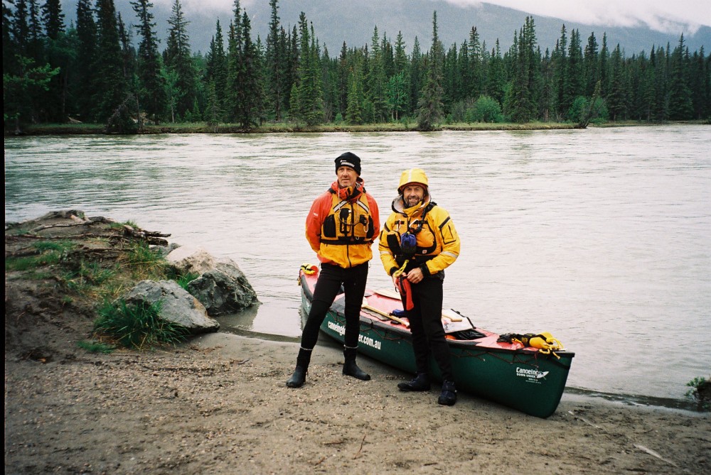
Tony & I ready to leave Jasper. Canoe fully loaded with 4 weeks of food and gear
We peeled out of the eddy and into the current and oh boy the canoe was heavy and hard to control compared with the day before. We waved to Ed and Sue for the last time and I felt a sense of sadness as I waved farewell. We paddled on the right side of the river where we slid down a few channels that had shallows and stranded uprooted drift trees on either side. Within a few minutes Ed and Sue were gone from our sight. We were now all on our own heading towards the Arctic Ocean in a northerly direction.
A near-white coyote or it may have been a wolf, paced on the right side of the river not too far downstream. It stopped, turned and watched us intently before trotting off and disappearing into the trees. The rain became heavier, shrouding the mountains around us in cloud cover. It was such a shame as we were now being denied the sight of the magical and enchanting scenery.
We passed under the 12-mile bridge and noticed a sign downstream saying ‘camp’ so we pulled over to a small island to have lunch. We were now absolutely freezing! Even though we were well dressed against the cold, the frigid wind still managed to blow straight through us.
We walked up the bank and found a table, a campfire ring and dry wood. I paused before walking a little further to where the area opened up and tents were allowed to be positioned. It was a great camping site, but it was too early to stop and we were so cold we could only think about paddling to keep warm.
We took out the stove, placed it on the table and boiled water to cook noodles. The extreme cold made it difficult to think clearly or even muster up the enthusiasm to enjoy lunch, but once the hot noodles hit the spot it helped to motivate us again.
We left the island moving from one channel to another avoiding the fallen dead trees that were drifting. The current accelerated and we soon found ourselves being swept sideways narrowly missing a huge drifting tree with the stern. I straightened up and minutes later we watched an eagle glide overhead. The wind dropped and as the day became still the clouds hovered around the high peaks giving the river a sense of eeriness.
We entered Jasper Lake which was shallow at the beginning but later deepened. We kept mostly to the left and to our surprise there was still a faint current in places. We could see smoke from a cabin way over to our left and my thoughts drifted to the occupants of that cosy cabin. Over to our right a few cars were on a distant highway. Tony and I spoke little.
As the clouds cleared, a mountain came into view with sheer, steep rock faces looking something like Mt Matterhorn, the famous but notorious mountain, which straddles the Swiss/Italian border. It disappeared from view for some minutes and reappeared again. We paddled around a big bend, the water slowed then quickened. With clearer skies we could see the mountaintops were carpeted with fresh snow. The visibility deteriorated once again and the rain poured down in torrents. We found a campsite on a corner near Brule tunnel. It was not as grand or as beautiful as our lunch spot but it had to do.
Cold and wet, we pulled ashore and carried our gear for 35 metres across the long wet grass to the campsite. We dropped our gear near a table and fireplace and when all the gear was over, we collected wood and Tony tried to get a fire going. The wood was soaked, but after using some toilet paper and stove fuel to create a blaze, Tony got it going.
The evening was quite miserable and the rain, the mud and the bitter cold didn’t help to lift our spirits. Even the rice seemed to be against us as it took forever to cook. However it was most gratifying to enter my tent at 11.30pm, strip off and get into my warm down sleeping bag. The rain got heavier as I wrote in my diary and a train passed by, tooting its horn before it entered the tunnel. It may be a long, cold and noisy night, I thought as I drifted off to sleep.
Day 2 – Saturday 7th June.
When we awoke, fresh snow during the night had covered the mountain peaks and a cloud layer had gathered half way up them. The mountains looked spectacular. As the clouds lowered and dispersed all the mountains, including the one we had named Mt Matterhorn, started to appear. It was cold, but beautiful, a much better day than the day before. I made for the loo which was amongst the trees 20 metres along a narrow foot track. It was enclosed on three sides, but it had no roof or door, it was a real open air toilet. Although my bum was chilled due to my pants being around my ankles, just being able to sit there and gaze at the white mountain range was something really special.
We took our time packing the canoe and didn’t get moving until 10.30am. The scenery around us was absolutely beautiful. The nearest mountain had a cloud band encircling it, like a halo. We could see the mountain above and below the cloud. Small flowering trees and wildflowers were blooming, creating splashes of vivid colour contrasting with the tall green spruce trees. We pushed the canoe from the mud bank and jumped in, our feet becoming wet and cold in the process. The current helped us downstream allowing us time to take in the amazing scenery. On the left, the shores were rocky slopes and on the right was a spectacular jagged mountain that rose vertically above us.

The scenery was stunning
As the river turned into Brule Lake the whole scene ahead started to open up and the mountains turned to hills. Behind us though, the impressive mountain range was once again slowly coming into view as the bleak black clouds began to disperse. On the nearer mountain range a long, slender band of cloud looked so perfect and part of the landscape, that I just felt I wanted to walk on it. I wanted to talk to Tony about the amazing scenery around us and share the day but sadly for some reason and so early into our journey, I could feel a chill from Tony. I didn’t know what it was, but I could feel we were not communicating like normal friends.
An extended line of extraordinary sand dunes stretched before us on the right, but minutes later to our horror, motorbikes and quad bikes were tearing up and down the steep sand hills. Our peace was shattered, and it no longer felt like a wilderness, but it wasn’t all bad. For the next 45 minutes we were given an incredible display of riding as we watched them tackle the steep slopes and dig up a lot of dirt.
The sun tried to come out as we headed back towards the narrow river. Brule Lake wasn’t as shallow as Jasper Lake so it felt easier to paddle. About six power boats were ahead near the next corner, where the lake turned into the river, but they moved off when we neared. The current accelerated as the lake narrowed and we were soon paddling at high speed through a section of small waves, which on our map were called ripples. Some of the waves were quite high and Tony ended up with a lap full of water.
We were now unfortunately heading away from the snow clad mountains where the sky above was full of grey and black clouds. It was disappointing to leave the magnificent mountain scenery behind, but we had no choice because if we wanted to get to our destination we had to head north away from them. Near the locality of Entrance the water was pushing and rushing against the concrete road bridge pillars at a frightening pace. It was scary stuff and I could see how novices could get into difficulties and be drawn into them by the current. Luckily we had the experience and sneaked through on the left, well away from the pylons, whilst being pushed along by the tremendously fast current.
Leaving the mountains behind
The Weldwood Pulp Mill before Hinton Bridge was an unwelcome sight. We were told that many Hinton locals were concerned with the river pollution it created and paddlers were warned not to drink any of the water downstream of the pulp mill. We stopped just after Hinton Bridge on the left near a car park. Noisy trucks and cars were tearing up and down so we decided to move on to have lunch. Within a few hundred metres we saw a good spot on an island so we stopped and cooked noodles again. As we were slurping from our bowls Tony suddenly said he was fed up with all the spruce trees that lined the river. I was a little surprised to hear him complaining about the countryside so early into the trip. I wasn’t sure if he was joking, but he didn’t seem to be.
The water was still swift and when we reached a bridge used by a mine, there were warning signs against trespassing posted on each bank. It rained on and off most of the afternoon and there was little to keep us amused along the way apart from spotting a few waterbirds and two elk. We stopped on a small Island before Plante Creek at 5.50pm after paddling 72kms. The rain finally stopped, Tony lit a fire and we had an easy night, though there wasn’t much conversation again. It was still light at 10.25pm.
Day 3 – Sunday 8th June
Day 11 – Tuesday 17th June
It was a misty morning and we couldn’t see anything further than 15 metres ahead. It eventually started clearing but when the sun did begin to peep through, within minutes it would cloud over again. We managed to get up earlier and leave camp by 8.20am. It was going to an interesting day as we were approaching the notorious Grade 5 Grand Rapids.
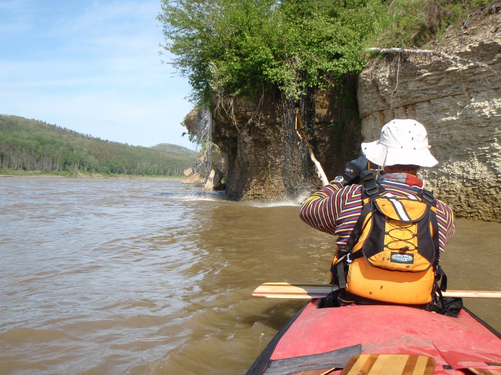
A moose and her large calf didn’t move as we passed within metres of them and soon after there were two pair of deer and they too just stood there and looked at us. We were puzzled as usually they run away. Not far from a small cabin, but on the left and opposite side of the river we noticed three big plastic drums. We felt the need to investigate so we pulled over. Next to the three drums was a heap of barley and some rotten fruit, just dumped. Tony picked up an orange which looked good, but I didn’t fancy eating one. We were mystified as to the meaning of the dumped ingredients, but some time later we were told it would have been bear bait. Apparently the hunters mix barley and a few ingredients together and because bears have an extraordinary sense of smell, they can smell it for kilometres. The hunter then sits up a tree close to the mixture waiting for a bear to arrive. Bang and the bear is dead………. somehow to me, that isn’t very sporting!
We arrived at House River where we were told that a guy called Darcy, who ran a Wilderness Outdoor operation, had a cabin. We passed below a beautiful cliff face, by some geese and paddled upriver and around the next bend. It was hard to see anything with the high banks towering, but at least we spotted some rusty metal walls on the north bank. We moved back around the bend where the banks were lower and where we were able to get out. There were no tracks so we walked through some very long grass for about 200 metres and found an abandoned cabin. It certainly wasn’t what we had been looking for.
Puzzled as to where Darcy’s cabin was, we moved on and stopped at another spot which turned out to be another false lead. When we had given up all hope of finding the cabin we paddled on downstream and then came across another track. This time, after following the track for about 250 metres up a ridge we found Darcy’s Hunting Lodge. There was no one there, only a few buildings and the major cabin which had five large antlers and five smaller antlers attached to the front of the cabin. Also pinned to the front was a sign with “Registered Trapline 1346” and another sign with “Mine & Darlene Zelman.” Again the grass hadn’t been cut for some time and the fenced vegetable patch was well overgrown. Nothing seemed to have happened here for a long time. We had a look around and then left. We were a little disappointed as it would have been great to have talked to someone who knew the area and the Grand Rapid. But it wasn’t to be, so we had to find out what the rapid was going to be like for ourselves!
It was said that we would hear the roar of the Grand Rapids from about 7kms upstream, but we were a little closer than that when we first heard the roar. It grew louder as we drew closer. Although I had read a couple of more recent accounts about the Grand Rapid, I got most of my information from reading manuscripts and looking at old photographs of early expeditions. To see photos of timber longboats going down the rapids was quite amazing and many didn’t make it. In the early days expeditions not only went downriver they also had to return so when negotiating the rapids by going upstream the boats were pulled up the rapids by man-power alone. Imagine how hard that would be. When I thought about us actually being here and retracing history in our own way, I felt very privileged.
In my research prior to the trip, I was never able to find any recent photos of canoeists tackling the rapids here on Athabasca River or find any of the Grand Rapid apart from a few historic ones, so we were about to run the rapid blind. Even Google Earth only had blurred images, so they weren’t of any great assistance to us at all.
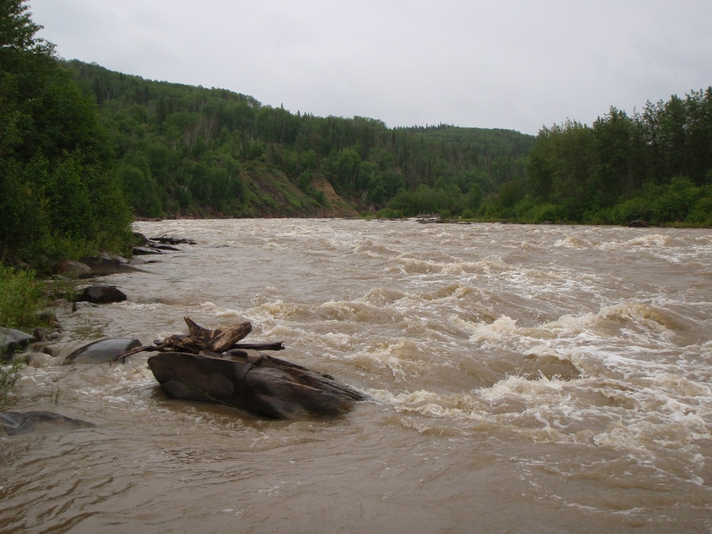
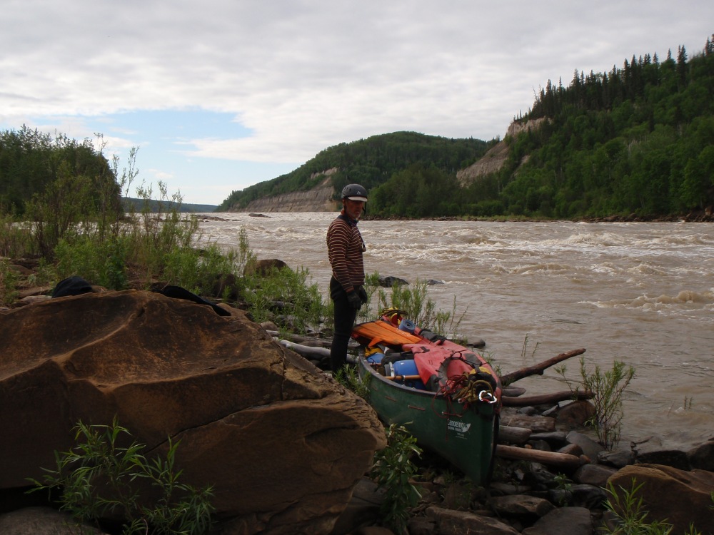
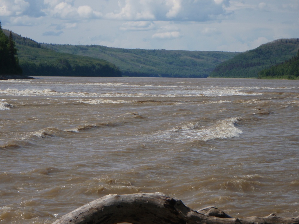
From a kilometre away the river looked like a huge funnel as it narrowed to nothing and dropped away out of sight in the far distance. It felt as though the edge of the world was near! We were entering another phase of our journey, the most dangerous one and like many of the early explorers we also faced the possibility of dying. The challenge of paddling into the unknown, hundreds of kilometres from help with our lives on the line was certainly more spine-tingling, gripping, and exhilarating than if the way ahead was safe, but strangely I wasn’t nervous. I relished feeling like an early explorer.
The Grand Rapids lay ahead
The left bank of the river looked steeper and more vertical than the right and the hills beyond the rapid overlapped. But in the foreground where the rapid started, just left of centre there was an outcrop of logs piled up and stranded. Other logs that were stranded on outcrops were protruding well out from the right shore and upstream of the island and behind these features the river fell alarmingly away and disappeared into a canyon.
As we got close we could see an island and before it the white water spread across the river. Early explorers used to row their York boats to the upstream end of the island, the part that we could see, unload their gear and passengers and with an empty boat, the best boatmen would tackle the rapid. Many boats didn’t survive and several people died. But that didn’t stop people from coming this way as at that time, it was the only way to get into the northern regions of Canada. The passengers’ gear was then transported to the north end of the island by a tramway that was built on the island. If the boats managed to get down, the passengers and gear were picked up at the downstream end of the island and often this could take days.
After reading historical accounts of the rapid it was hard to believe that we were actually here doing it. We were reliving history, but we too, couldn’t forget about our safety as we were about to paddle into a set of difficult rapids. My notes mentioned a portage track somewhere on the right hand side, but we were in the dark as to exactly where it was. Several hundred metres before the rough stuff we started looking for the track as well as concentrating on the smaller drops and accelerating currents that we were now amongst. At a safe spot after our first rapid we grabbed the opportunity to land. The shore was well vegetated and the hill, where we thought the track may be, looked impenetrable. We walked along the shore and inland towards the hill trying to find the track, but without luck.
We decided to move a little further downstream, although we certainly didn’t want to miss the track or we would be forced to tackle the huge rapid with a high likelihood of killing ourselves doing so. We side-stepped several waves and rode over a few small drops before riding across a mixture of cross-currents. We eddied out again, pulled ashore and I took the opportunity to search through my notes that I had made during my research for this trip.
Reading them gave me a much better idea as to where the track was located, making me feel much more confident. We didn’t want to be spending all day trying to find the track. Before jumping back in the canoe we walked along the shoreline over loose shale, rocks, vegetation and at times a steep crumbling slope to find it. At first, things weren’t looking too good as the banks ahead were getting steeper. But just at the point where it was too difficult to go any further, we noticed a small creek and a track a few metres inland leading vertically up the hill. An old sign saying ‘Portage’ confirmed our thoughts that this indeed was ‘The Track’. I don’t know about Tony but I was certainly relieved to see that signpost, because now we could get on. Before scrambling back to the canoe I made a GPS note of where the ‘Portage’ was.
Looking downstream beyond our portage point looked quite frightening. Not just the fact that there were some serious rapids, but it seemingly just kept going and going and we couldn’t see what was around the corner. What we did know however, was that for safety sake we couldn’t paddle any further than the portage point, although the thought of a difficult portage did make us think momentarily about paddling on.
We returned 200 metres or so to the canoe checking out all the drops, eddies and currents. We had to decide if we were going to line the canoe down the rapid or paddle it. If we did paddle, it was crucial that we paddled into an eddy about 20 metres upstream of the portage point. If we missed it we only had one other chance to get to shore and after that, we had no hope of getting out at all! To line means to lower the canoe down the rapids by using a rope instead of paddling.
We paddled down the first set of rapids to the portage point.
It was going to be tricky to paddle and we knew from research that the other two expeditions that had been this way, had lined their canoes on this section. After a good inspection we were confident that we had enough skill to paddle it.
It was make or break when we paddled away from shore. The rapids that we were going to tackle before the portage were not big, just grade 2s but that wasn’t to say that we couldn’t make a mistake and end up capsized, broadside to a rock or more importantly, miss our take-out point. We had so much gear in the canoe that if we did capsize we would never be able to swim the canoe to shore before being washed away. The chance of us getting the canoe back if it was swept down this long rapid was remote, more remote than where we were. So we had to paddle perfectly to avoid any mishap, our lives depended on it.
Rocks, some shallow and others well buried created white water. It was my intention to steer the canoe between these sections on the unruffled waters. Shallow rocks could push us off course or even capsize us, so I watched carefully, but with Tony’s body blocking my view it was a little hard to see everything. Logs stranded on rock shelves and rock boulders protruding from the shore forced us to paddle away from the bank and into the faster currents where we skirted some of the drops and paddled over others. The rapids were not really that difficult but it was what could happen if we capsized that made the attempt that much more dangerous. When we reached our get-out eddy we performed a perfect break-in (turn) into the eddy which I was very proud of.
 We paddled down to the portage point and lined our canoe down the last few metres. Any further and there was no way of getting out before paddling the grade 4 rapids. We paddled down to the portage point and lined our canoe down the last few metres. Any further and there was no way of getting out before paddling the grade 4 rapids.
We had taken it easy and at no time were we under any threat of losing control of the canoe. We cut into the eddy ensuring the bow was pointing upstream which gave us more control. The elation and relief of being safe was very satisfying. All we had to do now was to line the canoe around a rock shelf that jutted out from the shoreline into the river for about 6 metres. With throw lines attached to both bow and stern we held onto the ropes and lowered the canoe down slowly and carefully. When the canoe was safely guided around the rock shelf we used the stern and bow lines to pull it across the eddy and back to shore.
We had done it! We had managed to get the canoe pulled up onto the rocks only metres from our portage route. I felt like celebrating with a high five, but unfortunately as Tony and I weren’t gelling it put a dampener on my own enthusiasm.
A few metres from where the overgrown portage trail started there was a white square sign with the words, ‘Grand Rapid Portage Start’ and a red triangle with an ‘X’ inside. We loaded packs on our backs and bags over our shoulders and water containers and bladders in our hands. We were really laden down and as we started our steep climb we didn’t have any idea how long it would take or what terrain we were up against. Within seconds the slippery trail had us out of breath. It headed near vertically at times levelling off to a steep incline. For 25 metres or so the track was on the edge of a steep embankment, and had we slipped, we could have fallen to our death into the cascading creek.
The first part of the portage was very steep
Once the trail started to move away from the creek I felt a lot safer though it was still slippery and steep. Breathing heavily as we neared the top of the hill we came to a clear area which was a small meadow. It would have been interesting to know if the meadow had been cleared by man or if it was a natural clearing but at the time it didn’t matter. It was a relief to drop our heavy bags and sit down for a few moments to rest and catch our breath. We didn’t get to sit too long though as the mosquitoes were soon having a feast of our bodies.
We immediately returned for another load, covering a distance of 100 metres or so, and went through the same routine. Up the almost vertical hill, slipping and sliding, and drawing deep heavy breaths with the sheer exertion. We rested for a few minutes at the meadow and instead of returning for the canoe we decided to carry on and portage the next section. Although this section was not as steep, it was still incredibly tough and demanding. It appeared that the trail hadn’t been used yet this year as trees were strewn across the trail. We either had to break our way through the branches, climb over them or make a new route around. The heavy loads on our back and in our hands made it all the more strenuous to fight our way over, under and around and the mosquitoes didn’t make it any easier. There were several creeks that stood in our way and had to be crossed. A couple of them were particularly muddy, deep and steep which made it difficult to get out. The thick gooey mud sucked at our feet and legs making it near impossible to move, but it was the steep gully sides that created a near impenetrable barrier to get up and over. We struggled, but we just kept trudging on. If we didn’t the mosquitoes would make a meal of us. Tony was slipping, sliding and falling on his bum, his newly acquired sandshoes providing little, if any assistance as they didn’t have much grip in the mud.
The forest was quiet, but at times when there was a slight clearing down to the valley we could hear the whistle of a kite and the roar of rapids. As much as our trek was so very hard and very physically demanding, I couldn’t but help revel in the feeling of being in the midst of the Canadian Wilderness.
When we eventually reached the end of the portage we were muddy, we were sweaty and we were literally covered with mosquito bites. Despite this, there was a sense of elation at what we had achieved, even with the knowledge that we had to repeat the process again and again. We spotted a wrecked canoe lying in the bushes, a sober reminder that we had made the right decision to portage.
Here, at the bottom of the portage, we scrambled over to the rocks in the river, trying to get a better view of the rapids in the right channel, this being the channel we would have come down if we hadn’t stopped. Although it was a mass of bubbling white water it didn’t look as bad as the books and information described. We felt a slight temptation to paddle down it with our empty canoe but at the back of our minds was the wrecked canoe laying in the bushes just metres away. We knew that if anything should happen and the canoe was lost or severely damaged our trip would be over. The rapid was graded as a 5, which is the most dangerous and difficult of all rapids and although we couldn’t see around the bend, what we could see, certainly didn’t look like a 5. However, saying that, a rapid always looks smaller from a distance than it really is and looking closer at the nearer holes, they did look bigger than they first appeared!! Yes I think it was too risky to run it in a canoe, but for a white water kayak in the right hands it looked possible.
Looking up the rapid where we would have paddled if we had decided to paddle.
This section didn’t look so bad but we couldn’t see what was around the corner
We started our walk back. It had taken us 40 minutes to get from the meadow at the top of the hill to the water’s edge at the end of the rapid, but it took only 30 minutes to walk back without any gear. Walking back free of gear felt wonderful. We noticed another canoe that appeared intact near one of the muddy washed-out creeks. I wondered if the owners had got fed up with pulling it and just left it there as it was a difficult section to traverse. But if they did, how would they have gotten out of the area without a canoe. It was a mystery!
Returning for our second load was no easier. It was still arduous and very tough and there was no denying that our load was awkward and really heavy to carry. I felt that my arms had been stretched, almost as though they had been put in a torture rack and lengthened.
Eventually we returned for our last load, the canoe. This wasn’t going to be fun or any easier than carrying the gear as we had to get the heavy canoe up the steep, slippery slopes to the meadow whilst still carrying some gear on our backs. The first steep part, with the sheer drop into the creek just metres away was gruelling. The canoe was heavy and the mud seemed to suck it down making it difficult to move and at the steeper parts it wanted to slide back down the slope. We slipped underfoot and grunted with sheer strain while the threat of being pulled back over the vertical edge if we lost control was very real. Tony took one end of the rope that was attached to the canoe and walked about ten metres away whilst I pulled from the bow of the canoe. Together we pulled and inched the canoe slowly and laboriously and painfully up the hill. When we could see the top we sighed with relief, though that last part up onto the meadow was still tortuous and difficult with a tight turn and one last steep section to negotiate.
We started the final journey from the meadow to the portage end with wobbly legs. Tony pulled on a long line and I now pushed from behind the canoe. With all the ups and downs, sharp corners, muddy creeks, felled trees and narrow path the canoe proved to be a handful which stretched and strained our bodies to the limit. Crossing the muddy gullies, especially the two big ones we were straining painfully as they were so difficult. We still had some gear inside, so lugging 45 plus kilos with a heavy load on our backs was tough to say the least. We’re no spring chickens, I’m 57 and Tony 52 but we just kept plugging on till we got the job done. I was both amazed and impressed with Tony’s commitment and stamina. I suppose because I didn’t think that he was really enjoying the journey as much as me, he may have been tempted to go slow and have less enthusiasm. But he didn’t, he kept working right up to the end. There was no doubt that we were both shattered.
Throughout the portages the mosquitoes were relentless with their proboscises continually piercing whatever part of our bodies they could, and even when we were near the water’s edge and away from the long grasses, they never let up.
Once settled in at our campsite I went for a walk downstream to check out Little Grand Rapid, so as to be forewarned of what to expect the following morning. I could still hear the kite whistling away but it was the amazing rounded rocks that showed me that nature has no bounds. These rocks were shaped like giant eggs and some were broken in half, almost like an axe had cut them across the middle. I’m sure a geologist would have a field day here. It was truly remarkable to see such incredible rocks and imagine the force it took to break them.
From the riverbank, Little Grand Rapid didn’t appear to be a life-threatening rapid and it looked as if we could paddle it without portaging. I returned to camp pretty happy and then walked upstream to have another good look at the grade 5 rapid section that made us portage. We would have come down the left channel, looking upstream but the main drop which was on the right side of the island was several hundred metres away and a few hundred metres wide. From a distance it didn’t look so bad. Looking through my binoculars though was a very different scene, especially when I took into account that I was so far away from the big drop. In fact I think it was quite huge and there was a mess of difficult rapids below it. The right bank looking upstream was just a vertical cliff so getting out and portaging would have been impossible. There were also huge rock bars, one close to the island and another in the centre of the channel that obstructed the water and diverted it in different directions. So on second thoughts it would have been suicidal for us to paddle it in a canoe. One day though, if they haven’t already, someone will do it in a canoe.
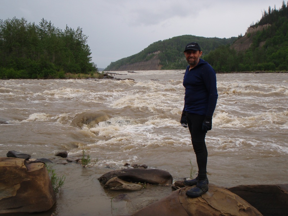
At the point where the two channels meet
I looked at the north end of the island which was closest to me and visualised the long boats from the past coming down the rapid and stopping before the two channels came together. There was a flatter eddy area to the right (west) of the island which was probably caused by the rock bar upstream and this I imagine was most likely the place where the boats stopped and loaded gear and passengers.
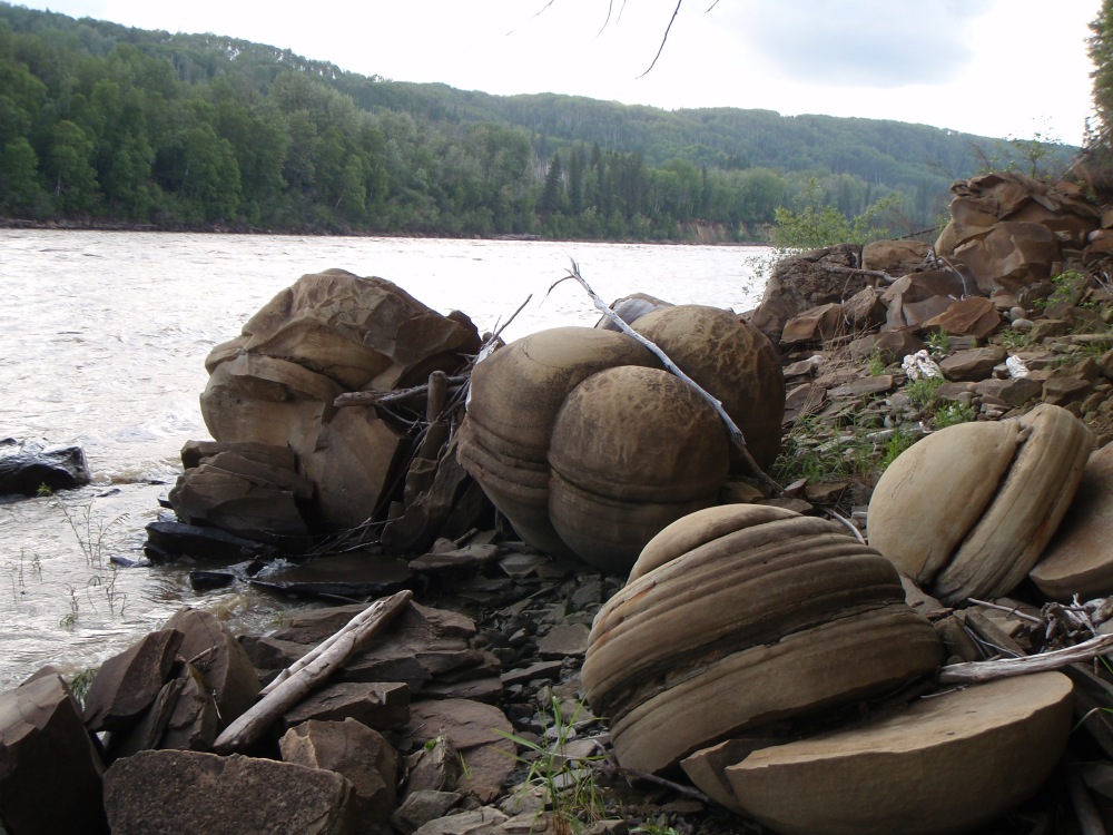
Amazing looking boulders. It was worth the paddle just to see those.
Back in camp I had a good wash which felt just brilliant after such a hot, sweaty and dirty day. Once clean and sparkled up, I made dinner. The portage took five and a half gruelling hours. I was in bed by 11.30pm and asleep before my head hit the pillow.
Day 12 – Wednesday 18th June
I woke to the sounds of the thundering Grand Rapid and a beautiful sunny morning. When I crawled out of my tent I saw the sun shining on the far side of the river. Tony, who had risen early, said the rapid looked pretty special as it had been completely covered in mist.
Huge round rocks were showing in the vertical cliffs on the other side of the river. One day, with a little more erosion, they would simply fall. Disappointingly just when I wanted to take photographs the cloud covered the sun taking the colour and sparkle from this dramatic scene.
We packed up our gear with some reluctance as this was an incredible place to be. We were here in the midst of the Canadian Wilderness, at the ‘Grand Rapids’ a place in Canadian history and a place that has changed little if at all, since white man first saw it. At 9.20am we finally pushed our canoe off the rocks and into the wavy water. The waves created a few problems as they constantly slapped into the canoe, pushing it back towards and against the rocks that we were trying to launch from.
Tony finishing packing before casting off
Having scouted the rapids the previous night, I felt both confident and excited about paddling the ‘Little Grand Rapid’, first we kept to the right and then moved over to the left dodging all the bigger waves. We were still being bounced around so when we saw an easier route we then crossed back to the right side again and seemingly in no time, we were clear of the ‘Little Grand Rapids’.
We paddled over a few swift but choppy sections before the valley fell into silence. No longer could we hear the roaring thunder of the rapids, not even the sounds of running water. All was completely quiet and we began to see grazing deer again. Along with the silence came the beautiful hills and sand cliffs, particularly in the region of Brule Corner. We knew little about Brule Rapid only that it was a grade 3 – 4. Although I should have been feeling tense about what lay ahead, I felt a sense of composure and calmness as I basked in the clear fresh air and the wonders of the magnificent wilderness around us.
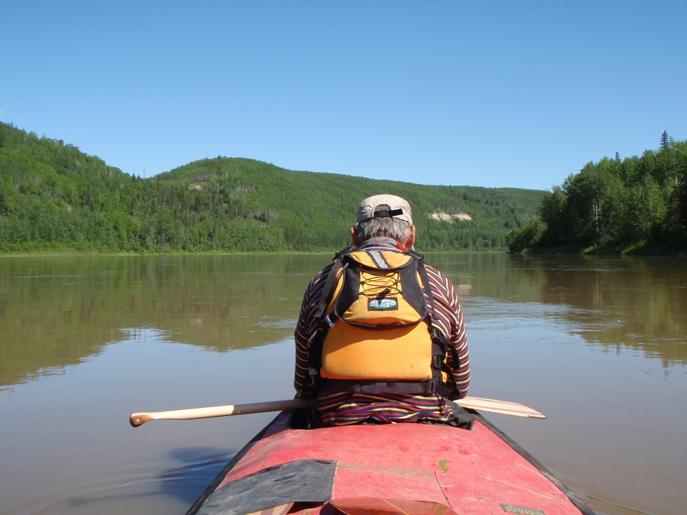
The river became so tranquil
About a kilometre from the Brule Rapid we began to get ready to tackle it. I took my camera and GPS off the deck and we both donned our helmets and jackets. We swapped our paddles from our bent shaft to our straight shaft paddles. The straight shafted paddle would give us more control in big water. Within minutes, and without us having to paddle, the current had soon swept us into the beginning of the rapid. It didn’t look too bad as far as we could see, so we started paddling. Then the waves began to get bigger and by the time we had sliced through some really good standing waves, I thought it time to head to the left shore to check out the rapid from the bank. When we stopped Tony held onto the canoe whilst I scrambled along the rocky shore for a closer look. The rapid was classed as a grade 4 but the route that we were about to take close to the shore would only have been a high 2 or a grade 3. It was much, much bigger in the centre of the rapid but we fully intended keeping away from there.
I could see several big standing waves, a few boulders that we certainly needed to avoid and a few drops that would swallow us up if we didn’t miss them but on the whole, the rapid didn’t look too much of a problem.
We started our paddle down the left, made some tight turns to avoid boulders and blasted through some big waves that were far more exciting and certainly much bigger than they looked from the shore. When we were safely at the end we were well pleased with ourselves, and quite relieved in a way as the grading of the rapid was perhaps a bit higher than was warranted.
We had lunch just downstream of the rapid at 1.30pm. I set off the ‘Spot Locator’ so as to give our latest position to our crew back home just in case we came unstuck at the next rapid. At least they would know where to look if we didn’t contact them for a few days!
It was about 28kms to the next rapid and although the current didn’t feel very fast, we were drifting at 10kph. The scenery was good with steep hills covered with deep green spruce trees and intermingled with patches of vertical rock and dirt cliffs. However, we didn’t see any wildlife until a lot later when we saw deer walking up a steep embankment.
About 500 metres before we approached ‘Boiler Rapid’ there were a few waves starting to rear up. I steered to the left and tried to reduce the difficulty by dodging many of the waves but we still had a pile to go through. They weren’t that difficult, but we still kept a sharp eye for hidden rocks. When the rapid began to look a little more frightening we decided to land on the left to take a look ahead. There was a low, wide swampy section downstream, which was muddy from the dropping water levels. Once out of the canoe we were instantly under siege from the mosquitoes, and then there was the mud with bear tracks. During an expedition the year before, kayakers had talked about seeing several bear and of having close encounters with them at nearly every rapid. The bear tracks were a warning to keep a sharp look out, but the mud was far more unsettling. We slid, slipped and sank in the mud as clouds of mosquitoes followed. Thankfully it was only mosquitoes and not bears that chased us!
After checking the rapid from the side of the river it didn’t look too difficult if we tackled it in sections. However, there were plenty of rocks and several big boulders that we would have to move around to safely negotiate the rapid. We stumbled 200 metres back to our canoe, muddied from our walk. Again the rapid looked much easier than the notes we had read indicated, so our confidence was high. After pulling away from the shore we paddled down the left side of the river dodging several rocks and a number of big standing waves until we were safely in the flat water.
It was only a couple of kilometres to the ‘Middle Rapid’. We took it on the left and stopped half way down. I jumped out and walked downstream until I could see enough of the rapid to feel that we would be okay. It was dotted with boulders, waves and holes but with good steering it appeared, from the bank at least, that with good teamwork and by using all our paddling strokes, we could negotiate around them all. The current soon whipped us away and it wasn’t long before we had to dodge boulders that if we hadn’t, would have proved fatal. We slowly moved away from the bank to miss some ugly holes and rocks before moving back over to the left to avoid some of the big waves. The water then flattened for a short distance before we approached one last set of large standing waves. We sidestepped the deepest holes and powered through some towering waves, which in actual fact, were much bigger than they looked when first approaching them. On that last section Tony was lucky as he was nearly washed away by the force of the waves, but we had triumphed through rapid number three and what a feeling it was!
Our day was not over, as 4.5kms downstream was ‘Long Rapid’. My information told me to go left at most rapids, but my Google photo of Long Rapid showed a better route on the right. Although the picture was taken from a great height I could still see the biggest white water. I decided to follow my instincts and take it on the right, but before the main rapid I got out for a reconnaissance run. A steep earth embankment followed the left shore and between us and the bank, the river ran for several hundred metres with a continuous stretch of grade two/three white water. Apart from several big boulders, the waves and the standing waves looked very manageable from the bank. When we paddled it, it proved easy to dodge the boulders and the standing waves, which actually were just plain good old fun.
With four of the big rapids behind us it was time to relax and forget about the two big grade 4 rapids that we had yet to tackle as it was that time of day to find a campsite.
The river banks had steep sides giving us no camping options so we kept going and eventually found a good place on the left after the next bend. We camped on sand, with just enough room for two tents. The campsite was surrounded by grasses and logs, but at least we had rocks, instead of mud on the river bank. The mosquitoes were bad, but so were the hundreds of large black flies that settled on everything.
We had paddled nearly 100kms today and we were both pleased with our performance in the rapids.
Day 13 – Thursday 19th June
Though it was a sunny morning, the sun hadn’t yet reached our campsite, so when we moved around camp we were still in the shade. I went for a number two and millions of mosquitoes followed me. When I took my pants down they went berserk. I couldn’t pull my pants back up as I had already begun the morning task so I tried to get it over and done with as quickly as possible. I flapped and slapped at my backside but the mozzies were unrelenting. I ended up with four bites on my penis and way too many for me to count on my bum. I tried not to scratch them!
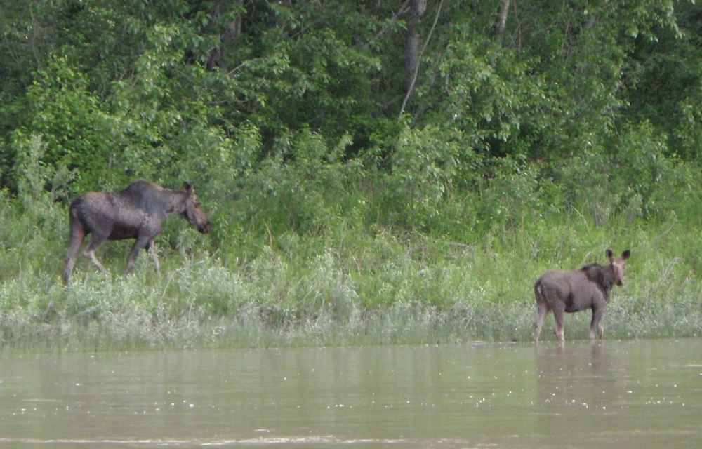
We left around 9.00am and paddled a few kilometres to ‘Crooked Rapid’ where the river did a big ‘U’ turn to the right. My Google Earth pictures of the rapid were very poor so it was impossible to have any idea where to go. We kept to the left side and the outside of the bend where the rapid appeared to be calmer. Over to the centre and far right the rapid raged as water cascaded over high long ledges. With the water being fairly high we were skirting most of the white water. Ahead, we could see two bears on shore, which was pretty exciting, but as we got closer they appeared bigger than bears and in fact, they turned out to be two young hefty moose! We looked at them and they looked straight back at us. I felt like drifting and really watching them for a while, but as we were floating between the white water sections, and we were bound on the right by big rapids with another rapid coming up, we couldn’t be too complacent. As we left the moose to continue to graze our focus turned to the rapid ahead, which was rough on the right, rough on the left, but slightly calmer down the centre.
I steered towards the centre of the river where the canoe started to accelerate and slice through some big waves. Water broke over the bow giving Tony a drenching but I soon skirted over to the right and into calmer waters. It was quite pleasing to have negotiated another big rapid. We knew that Rock Rapid was 500 or so metres away, and although we didn’t have any idea how to negotiate it, our confidence was still high.
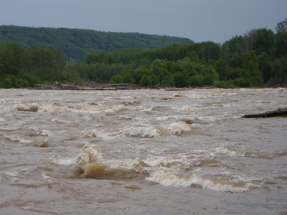
All the big waves were on the left hand side of the river, so we kept to the right side which was still the safer. As we approached ‘Rock Rapid’ it didn’t look so bad downstream, but as we got closer I could see a bundle of big waves peaking and exploding like an erupting volcano a few hundred metres ahead. Knowing that we were heading for trouble we had no option to divert and as it now looked completely calm on the left hand side we headed over, foregoing the chance of getting out and checking our route.
It seemed safe enough to take the rapid on the left so as we moved across the river on an particularly swift current, our heavy canoe was being whisked away as if it was a cork. By the time we reached the centre, I suddenly noticed a flat line of water that spanned the whole width of the river and beyond it the river dropped and disappeared over the wide ledge. At the bottom of the fall there was a huge high wave waiting. We couldn’t escape to the safety of the left side as it was too far, the water too fast and the bank was actually lined by a vertical cliff and worst of all, we had come too far to go back to the right shore! The only way forward was straight towards the ledge. I looked beyond the ledge and thought shit – bloody hell…..this is a big one, we could be in trouble here.
Over the roar of the rapid I shouted to Tony to straighten up and just go for it. There was nothing else we could do. Our chances of getting through it seemed slim as it was one hell of a drop with a massive wave that followed. Although we could have been looking at death in the eye or at least be subject to a horrific capsize, I didn’t feel any panic or any real fear.
Tony put in two good strong bow draws strokes which brought the bow around, so within seconds we managed to get the canoe straight. We were soon at the top of the ledge with the massive wave dancing wildly before our eyes and I could only think of paddling strongly. We slid at great speed, down what seemed to be a giant water slide. The wave at the bottom was colossal. I shouted to Tony to paddle hard as we had to hit it with speed – oh shit……
As we headed down the ramp and towards the monster wave I expected to be sucked in and spat out. I still had no fear and I don’t know why. Maybe things were happening too fast to sense fear or I just knew there was no turning around, and we had no choice but to deal with the situation. At the bottom of the slide we looked up to see the wall of water towering above us and it really didn’t seem possible to get through it without capsizing. The size of the wave was bigger than anything that I had ever been through before.
What goes down must come up and by hell we did come up. The heavy canoe charged through the wave and Tony got a walloping. For a fraction of a second he was gone, then the wall of water crashed on me holding me captive for a few seconds under the bubbling aerated mass of water. It took us a while to adjust our vision and see what was ahead as a waterfall of water was cascading down our faces. I was expecting another big wave but the next one was much smaller and we speared through it without problem. It was an amazing experience! We thought we were going to be gobbled up by the huge roller coaster and somehow we came out of it intact and still upright.
With a ton of water now held on the top of our canoe causing a little instability and Tony praying to any gods that would listen, the waves started to ease. It was hard to believe that we had gone through such a massive wave! But the rejoicing had to wait as the canoe was filling with water as it puddled on the full-length of the spray deck, drained into our laps and seeped through our leaky skirts. Although at the time of breaking through the waves the canoe didn’t feel remotely unstable as it started to fill with water it soon became much heavier, tippier and a lot harder to control.
As the river started to turn to the left we could see water falling off a small cliff. We desperately needed to bail out so landing on a rocky shore next to the waterfall and low cliffs was a bonus. As we pulled into the eddy we were pumped with excitement but most of all, we were relieved to have passed through the last rapid without swimming. Capsizing could have been a disaster. The weight of the canoe upside down would have been one hell of a hard job to drag to shore and with the water being so cold we might have frozen to death before we got there.
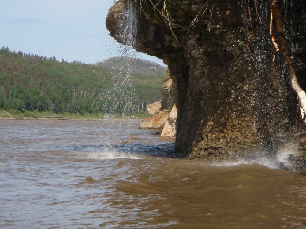
Fresh water falls from a small cliff
I had read the account of a pair that paddled the rapid in 1977. They had capsized on Crooked Rapid and ended up swimming down Rock Rapid and further for over twenty minutes. Separated and near frozen to death they managed to get ashore at different places. Luckily the next day a research team in a jet boat just happen to be doing a survey and found one of them and later both were rescued. If it hadn’t have been for the research team being there on that particular day they could have died.
Anyway we were safe, we had learnt a lesson and experienced a bit of adventure. Before the trip I would never have believed we could have taken a fully loaded canoe down such big rapids and felt so stable. Having so much weight in the canoe though, caused it to handle a lot more sluggishly than when there is little weight inside, but it was extremely stable.
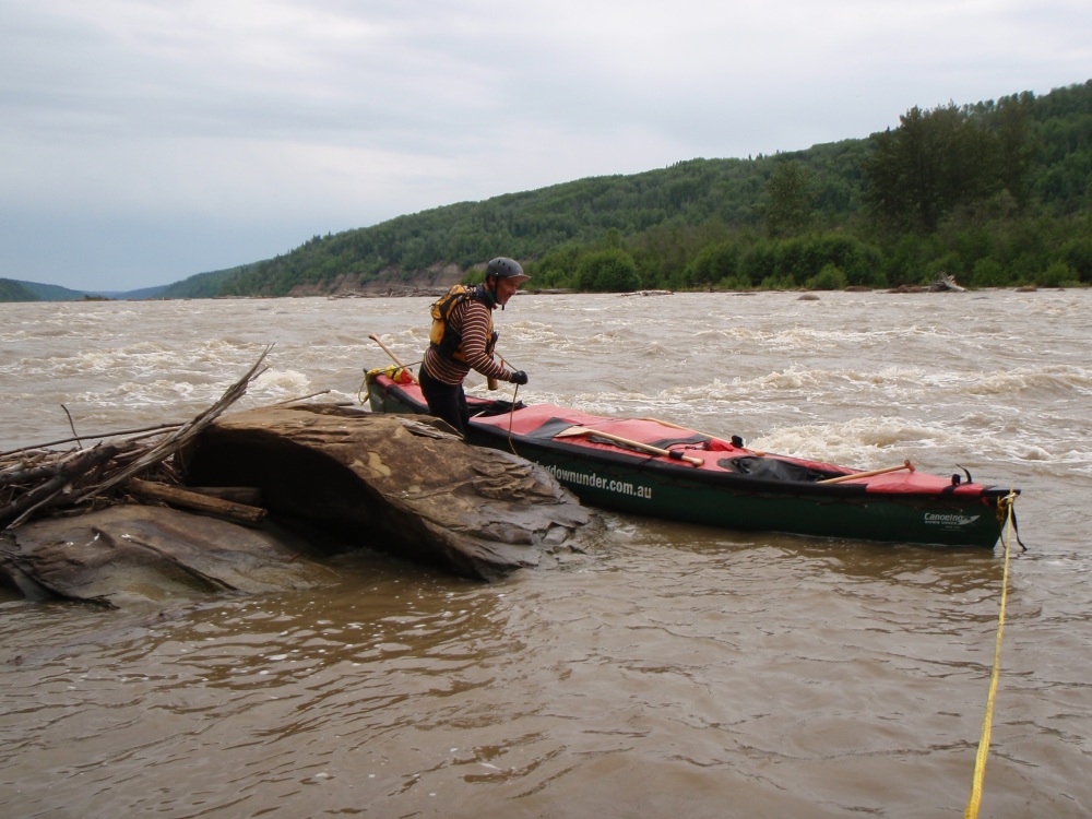
We took photos of the waterfall, emptied heaps of water out of the canoe and talked little about our experience. There was no dancing a jig in celebration which was sad as we still weren’t bonding as we should. Once back in the canoe, we continued on, passing an island before reaching the ‘Little Cascade Rapids’ which we were able to skirt on the left.
Tony takes a picture
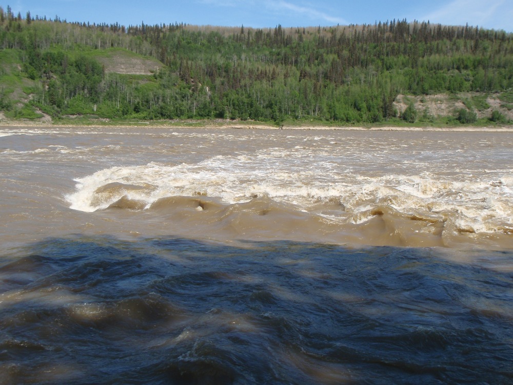
As we approached the next grade 4 rapid the ‘Cascade’, I could see that it was clear on the left but raging over on the right. I said to Tony that we could keep going and then eddy out before the next set of big waves, which from a distance didn’t look too bad. As we approached a place where we dared to go no further we turned the canoe and tried to eddy out. Unfortunately there was no eddy, the current was fast and the shore was smooth rock so it was near impossible to stop. As we tried to grab the rock shore without any luck the canoe was slipping backwards so we had no choice but to attempt a quick turn and head downstream and paddle the rapid blind.
To our right the river was full of white water, as the water dropped over ledges and created holes and waves downstream of the ledges. We hurried our turn, however we were calm as we straightened up and readied for the worst. What we had seen over to our right was quite frightening but we were quite lucky, as, apart from a few boulders being in our path, we were only challenged by some big standing waves which we managed to sail through without problems. We noticed an eddy behind a long log that was caught up near the last part of the rapid, so we paddled into it.
Cascade Rapid
We landed and then walked along the shore and had a good look at the rapid further over and realised we were lucky to have taken an easier route through Cascade, which was classed as one of the biggest rapids on the river. We watched on as the water cascaded over the big ledges and drops that spread over three quarters of the river.
We had a break and took photos before scraping over a shallow ledge at the last part of the rapid. We were free and apart from some small rapids there was only one big rapid left, Mountain Rapid. In the last two days we had been negotiating the most dangerous section of our trip, so the challenge was to get through it all without swimming! Only Mountain Rapid now stood in our way.
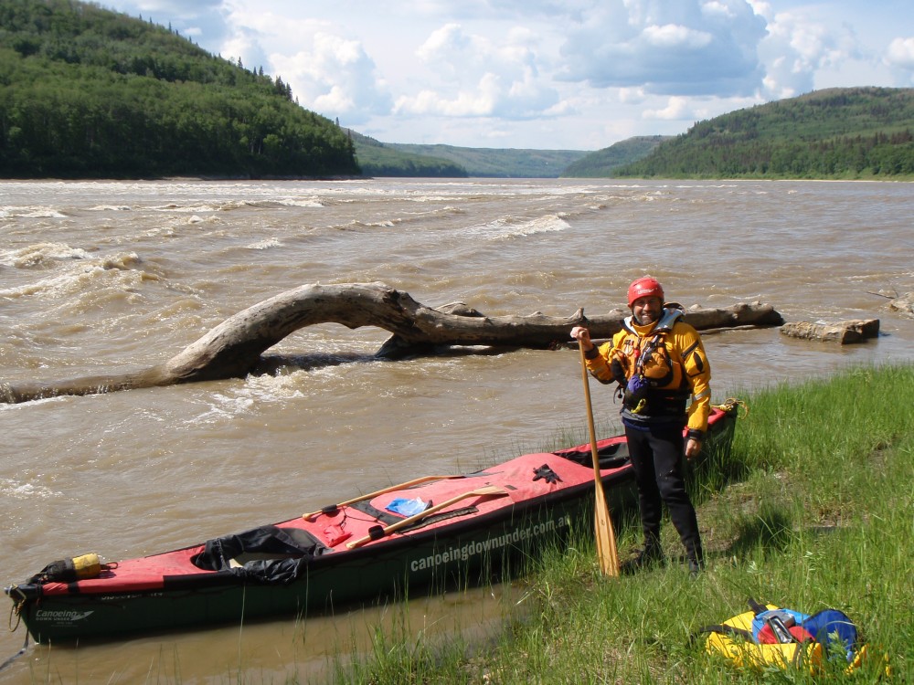
Having a break at Cascade Rapid
Just before Mountain Rapid we were able to eddy out on the right. This time, the picture I had of the rapid from Google Earth was clear, so I could see that the rapid was impressive and it looked better to do it on the right, rather than the left.
Tony stayed with the canoe while I walked along the edge of the river to check the rapid. It was quite big, but there were narrow gaps without ledges that we could sneak through. Right here, left there, miss the big hole, back to the right. I was pretty confident that we could follow the route as long as I remembered it. From the information that I had gathered this was supposed to be the most feared rapid on the river, but to me it didn’t look too bad especially when I broke it down into sections. I expect the river must vary in difficulty at different river heights so we were probably lucky the river was as high as it was. Despite the last expedition seeing lots of bears at the rapids, some unfriendly, I didn’t see any as I walked the shores.
Mountain Rapid
Back at the canoe I explained to Tony our plan. We took off following the route I set in my head. We steered right of the first ledge, then moved into the centre of the river to follow the ‘V’ chute which led us to a mass of standing waves, but at least we avoided big drops on the right. Once through the waves we paddled back over towards the right to clear several other waves and drops that looked much too big to mess with. The longer we paddled the more relaxed we became, but we still had to concentrate as we weaved our way down the last major rapid. The current pushed us along at great speed and all of a sudden we found ourselves beyond the major drops and heading into calmer water. Skirting the last set of rapids I looked over to our left and beyond the hills and realised that we were no longer in danger. It was exciting to be safe, but also a little depressing that we had finished all the rapids. I felt like celebrating but we had little to celebrate with, so we just moved on.
The tail end of Mountain Rapid
Within minutes we were out of the valley of rapids and to our credit we had paddled them without too much drama. In fact, I felt a little disappointed, not only because we were leaving them but because all the rapids had been much easier than what we had expected. It may have been because we were more experienced than some of the paddlers before us or the water was at a good level making the rapids easier. We were also very fortunate to have been one of the very few people to have travelled on this part of the river as the big rapids and the wilderness were a big deterrent to most paddlers. With the rapids all behind us there was nothing that could stop us now from getting to Hay River – Oh what a feeling!
Five hundred metres downstream, I looked back to see two steep-sided cliffs form a gateway and as we drifted downstream a little further the hills overlapped and the gates suddenly closed. It was like stepping out of one world and into another.
Looking back to the rapid section
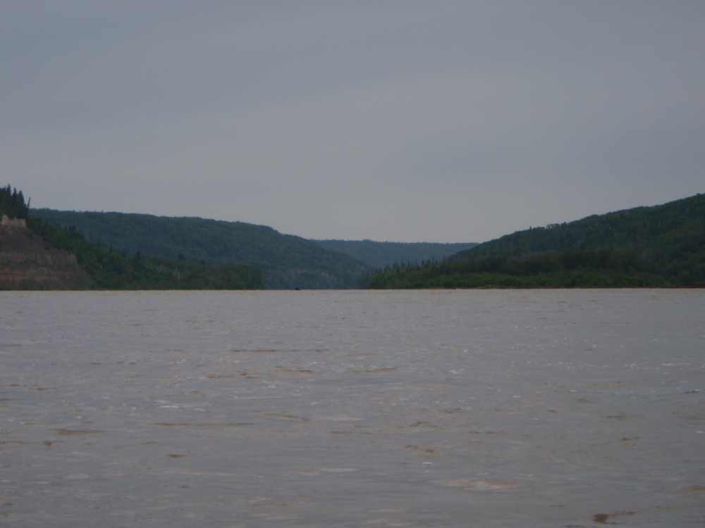
As we paddled through an area of rapid ripples, the hills fell back and the area before us opened up and we began another chapter. Power lines straddled the hillsides. Black tar sands were embedded into the steep shoreline, a sign of getting closer (12 kilometres) to Fort McMurray the oil sand capital of the world.
We saw a sign of life as small figures were walking on a golf course way over to the left. Further, a family was walking on a beach closer to town near an easy, but swift rapid. We paddled hard across the current and landed at their feet to talk for a few minutes and find out how to reach the town.
Moving on, we paddled under a bridge which was heavily crowded with vehicles. Fort McMurray was virtually at the end of the road and to see so much traffic was very surprising. The shoreline beyond the bridge had a spectacular low cliff line which we followed before turning up a channel that led to the Clearwater River, a nationally listed wilderness river. The Clearwater wasn’t clear at all, the current was against us and as we paddled close to the marshy mosquito-infested shore to get away from the current, it was shallow and slow going.
We eventually came to another channel on our right, which turned out to be a landing strip for float planes. A beach on the corner of the two waterways was full of cars, sightseers and fisherman. We were told by the couple we had met earlier that it wasn’t safe to camp in the area as there were too many drug addicts around. With Fort McMurray being a mining town full of well paid workers, drugs were said to be rife.
We pulled up next to a cyclist sitting on shore as we thought he would be a respectable local and be able to share some information, but he was surrounded by empty beer cans and slurring his words. We moved on and landed a little further and then I walked over to the office of a float plane company and asked if there was any way we could either camp or leave our gear in their compound. A young lad seemed happy to oblige and was helpful, but his father wasn’t quite sure. He didn’t want us to camp, although he eventually agreed to let us leave our gear in his shed and the canoe in the compound.
A motel was now beckoning in town, but first we had to get our gear together and leave what we didn’t need in the shed. With everything secured we walked into town loaded down with washing and found the Ace Motel. It cost us $165.00 a night which, after being used to paying nothing for campsites, was a lot of money. Nevertheless it was well worth it.
It was great to have a shower, do our washing, make phone calls and be able to go out for a meal. We had been told that the Montana Steak House, a short walk away served good food. I ordered salad, Yorkshire pudding and beef, two Canadian beers and a small sweet taster. It was pretty good. The waitress who was from out of town was very pleasant. She was there like most people, to make money. We tipped her. It was customary to tip, but it was so annoying to have to tip everyone in the service industry.
Tim Horton’s coffee seemed to be a Canadian institution, so we had to try one whilst we had the opportunity. There would be no chance further north of here, but after drinking it we didn’t think the coffee to be anything special. We sat by the window and watched people of all nationalities, who were employed in the oil sands industry, come and go. A very long queue of mainly huge four wheel drive vehicles filed through the drive-through. It would have been quicker to park and buy it inside but that was life now. We were astonished to see such a big queue. Why do people wait forever at a drive-through? The supermarkets and shops were still open, so before retiring to the motel, Tony and I went our own ways to check them out.
***********************
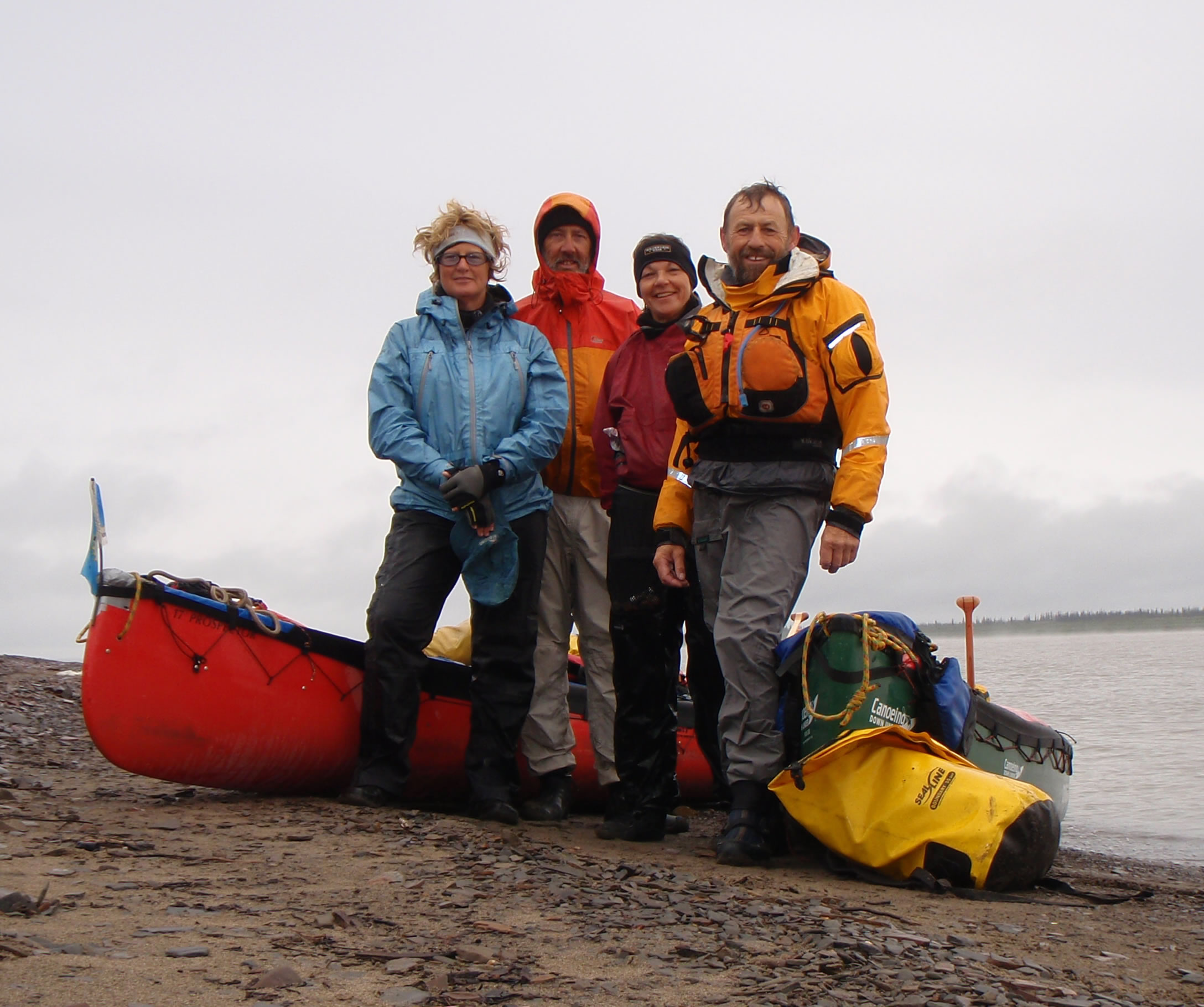
This was just a few days of our journey down the Athabasca, Slave & Mackenzie Rivers. We met our two friends, Alaine and Leonie at Hay River at our 2000km mark and then continued 2000kms down the Mackenzie River to the Arctic Ocean.

The Team for the last 2000kms. Leonie, Tony, Alaine & me
More can be read in my book Three Rivers To Tuktoyaktuk |