The Appalachian Trail
(Part of my Backpack, Cycle and Kayak Around the USA)
After paddling from New York city to Kingston, near Princeton, New Jersey and cycling around 1000kms from Kingston, I arrived at Damascus, Virginia where I was going to leave my bicycle and start backpacking 800kms along the Appalachian Trail, (AT) the most southern part.
The Appalachian Trail (or the AT as it is known) is one of the most popular trails in the world. The trail winds through 14 states. It starts in the south on Springer Mountain in Georgia and finishes in the north on Mt Katahdin in Maine. Most ‘thru hikers’, a hiker that walks the entire trail, walk from south to north because it takes several months to walk it and the weather conditions in the south allow hikers to start early in the season. After reading so much about the trail I just knew that it had to be part of my American Journey. Being 3,505kms (2,178 miles) long I also knew I couldn’t walk the whole length of the trail in the time I had in America. That is, if I wanted to paddle the Mississippi River, walk the John Muir Trail and do more cycling. With this in mind I had to choose one major section, and from my readings I got the impression that the lower part was a little more isolated and more mountainous and scenic. The weather was also better in the south at this time of the year so with that in mind, I had elected to walk the southern section from the town of Damascus in South Virginia to Springer Mountain in the Amicalola State Park, Georgia. My walking journey was going to be about 780kms long.

The Appalachian Trail was completed in 1937, is a privately managed unit of the national park system and is the nation’s longest marked footpath. It crosses six other national park systems, traverses eight national forests, crosses numerous state and local forests and touches on 14 states and is maintained by 30 trail clubs. More than 6,000 volunteers contribute about 200,000 hours to the Appalachian Trail every year. More than 10,000 people have reported hiking the entire length of the Trail.
I found the (AT) hostel a short distance away. It was a big old house owned by the church. There was no manager or caretaker to look after it, so it was left to the hikers and bikers to clean up their own mess. I soon found out that it didn’t always happen, it was often left for others or it didn’t get done at all. When I arrived some parts of the hostel were in need of a real clean. It wasn’t the Ritz but it was cheap, and for a $2.00 donation you picked your own bunk. At the time of my arrival there were about 25 other hikers. Most were exceptionally friendly and I soon felt at home. The majority of hikers had walked 740kms to get there from the southern end of the Appalachian Trail, so they were on a high. Some of them would quit there, but others would go on heading north, tackling the hills and facing the weather.
About 2500 hikers start the long journey every year but only about 10% will realize their dream. The hikers are like gypsies and nomads, heading on the long trail. They stop whenever they are tired, or when blisters or injuries force them to do so. Sometimes the comfort of small towns gets too much for them to let go. Along the way they form friendships and some even form relationships. They walk from shelter to shelter, from campsite to campsite, exchanging stories, writing their feelings or quotes in visitor books in the shelters. Being on the trail becomes part of a lifestyle. Between success and failure is a long thin trail that winds, ascends and descends like a yoyo across 12 states. For success they must follow this trail all the way. But for most, completing whatever they can will be their just reward. Whatever they achieve, it will change their outlook on life and themselves forever.
To get through it all, hikers will face rain, hail, snow and the bitter cold. Their pace will be slowed, their enthusiasm will wane but it’s the bonding of friendships, the warm sunny days, the spectacular views and a hostel somewhere ahead with showers, cool drinks and junk food, something different from nuts, raisins, chocolate bars and pasta meals that will keep them going. They will become bored and strained by the ever-winding tough trail, but at the end of the day, when their limbs and backs are released from the heavy burden, they exchange stories, laugh and forget the pain, and will be content and happy to be there. Soon I will be one of them.
On the AT, everybody has a trail name; such as Hellfire, Sweet Tea, Moon Pie, Stickman, Wombat, Johny Longdrop and Drongo. You name it, it’s out there. When I heard about the trail names, I thought it was a ridiculous idea. In fact I thought it was childish. Nevertheless, I decided to give myself a name before someone else gave me something more ridiculous, such as possum or wallaby. I chose ‘Wanderer’. I thought it summed up what I was doing at the time. It didn’t take me long, however, to realise that using a trail name had its advantages. It was individual and personal. There would have been dozens of Terrys on the trail, but very few people use the same trail name. So something I thought to be absolutely ridiculous turned out to be sensible and effective.
Going by the hikers in the hostel there seemed to be more women walkers on the trail than I expected. Most were in couples, either two females or a male and female, but there were several walking alone. Few felt threatened and thankfully they hadn’t been put off by murders that had happened on the trail some years earlier.
I was also surprised to hear that dogs were allowed on the trail. It seemed the in-thing for dog owners to take their dog on a long walk. The dogs wore harnesses, so they could carry some of their own doggy food.
Many of the hikers in the hostel had blisters, some had injuries but almost nothing could deter them from going on. They were a motivated bunch. They had a goal, and a dream to walk another 2494kms (1550 miles) to Maine. Most were young, eager and built like race horses. A few others, though, had fading aspirations and found excuses to quit. Most rested here for a few days. The eager ones, who were determined to walk the trail in the shortest possible time, stayed a day or so. Some keen ones were now walking up to 50kms a day, when their packs were at the lightest. On the next stage of their walk they had a steep climb to Mt Rodgers, but beyond it the high peaks would fade and the walking would become easier and the weather kinder. With this in mind most were trying very hard to reduce their pack weight. Many had already thrown some items out along the trail to save weight, others used their water bottles as mugs and many had light $10 raincoats and hardly any clothes at all. With 772kms behind them, they were now seasoned hikers.

The hostel at Damascus, Virginia
The visitor’s book was full of interest and intrigue. Messages were left for hikers that had been left behind on the trail, or about personal hardships and feelings. They left messages of excitement, messages of love, messages of despair. These messages alone could form the basis of an interesting book. The bush telegraph flourished along the trail and it took little time for hikers to find out what others were up too and what relationships had developed. Gossip was rife.
I was now wrapped up in the hype of walking this famous trail, but I was yet to prove myself as an AT hiker. I could not relate any AT experiences to my fellow hikers, although I could fall back on a wealth of past adventures. In front of me were five weeks of hiking. I had to buy food for this time, sort it out into day packs and then send it to four post offices along the trail. I also had to do my washing, get my hair cut, shop for some camping gear and pack my cycling equipment away.
Time around town was very enlightening. No matter what shop I went in, the hair dresser, the post office, the bike shop, the camping store, the supermarket, the people in them were very friendly and helpful. It was probably the friendliest town that I had ever been to.
My visit to the hairdresser was one of the most interesting. I waited for my turn to come. I listened to the hairdresser and her female customer gossip non-stop. It was a real social outing, exactly like you see on American films, so it’s no wonder a female hair cut is more expensive. They were really getting into the gossip and the funny thing was, I was drawn into it and found it quite interesting. Their southern accents made it even more entertaining. Listening to them chatter reinforced the fact that women can make a conversation out of anything and they really enjoy talking. When another lady came into the hairdresser’s the subject was changed to her son’s radical haircut, the streaks going through it and how nice he was. Then they talked about the film Titanic. They asked me if I had liked it. Then they started going on about the scene when they went below decks and sat kissing in the old car and how the windows started steaming up. That part really excited them but at times they were nearly in tears. When my trim was finished it was hard to leave, the gossip was addictive.
Sunday April 19th
It was probably the worst day to start my hike. It was grey and miserable outside and pelting with heavy rain, but I’d had my short rest, done all my shopping, packed all my gear so I was ready to move on again. I loaded my pack, took my bike to the cycle shop for them to store it for me for a few weeks, and returned to sweep my part of the hostel. It was definitely time to get on the move as one of the toilets was blocked again. It wasn’t a pretty sight!
When I shouldered my pack I nearly fell to the ground. My load was at least 10kg too heavy. I sat and thought of a way to lighten it, but I was reluctant to throw anything out and I couldn’t post it away as the post office was closed. As the severe storm lashed outside the thought of hugging a 33kg pack up the steep hills in the rain suddenly depressed me. It certainly wasn’t a good day to leave. I knew it and so did others who were waiting for the rain to stop. They stood stunned as I walked out of the hostel saying my goodbyes and into the pouring rain.

There are about 60 shelters with camping and another 60 camping placing along the way.

Damascus to Erwin 186kms
The town was deserted as I followed the markers up the main street, along the park and into the forest. By this time I too thought I had rocks in my head. After all the hiking experience I had done, why on earth was I carrying a 33kg pack on the first part of my walking journey. Hadn’t I learnt anything over the years?
Two soaked hikers stepped out of the woods on a quick march to the hostel. They said nothing. I passed them and climbed steeply into the woods from where they had come. It only took moments before I found myself surrounded by towering trees, my breathing became laboured and my calf muscles became tight. As the terrain became even steeper, I wondered whether I really wanted to do this. I soon realised that my fitness and my other superhuman strengths that I thought I had, were now being challenged to the max.
Like a tortoise, I shouldered my overloaded pack, resting briefly, and thought again how crazy I was to carry it. I hadn’t walked too many kilometres before crossing the Virginia/Tennessee border at 975 metres where I stopped for a rest. The capital of Tennessee is Nashville but the largest city is Memphis. I wouldn’t pass through Nashville on this journey but I was going to paddle through Memphis on my kayaking leg.
I sat on a log and rested my pack against a branch to take the pressure off my shoulders. It was a sheer delight to have the strain taken off them, but without warning the log gave way under my weight and I fell helplessly flat on my back, legs and arms waving in the air like a cockroach. With all my pack straps fastened I couldn’t move, so I was at the mercy of the Gods. What a Wally! I laid in the dirt, I didn’t know whether to laugh or cry, but it was surely a funny moment. I unbuckled my sternum strap, which joined the two shoulder straps across my chest, then my waist belt and wriggled free from the pack. With mud all over me I struggled to pick myself up from the forest floor chuckling inside but annoyed that my nice clean clothes were now dirty.
I managed to walk on. The Appalachian Trail is marked by vertical white-painted blazes that are 50mm x 150mm in size and positioned high on the trees. In the areas where the footpath is not clearly visible, one is within sight of the next but they are less frequent elsewhere. Two blazes, one on top of the other, indicate a change in direction. With these blazes and a defined trail it was hard to get lost. The blazes on the trees are permanent markers, so they can’t be stolen like trail markers, however, they do leave scars on the trees. It is said that there are 165,000 blazes along the way and it takes approximately 5 million footsteps to walk the entire length of the Trail.

The trail.
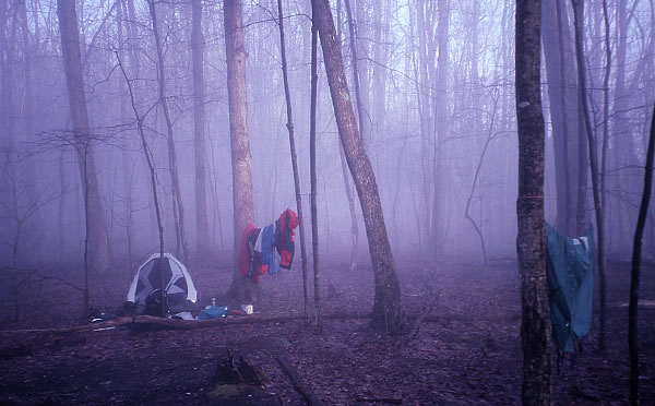
By the end of that wet, cold miserable day I had passed five hikers, walked 16kms and reached Abingdon Gap where there was a three-sided shelter in a small clearing. It was nothing spectacular but it was dry, and considering the weather it felt like the Ritz. It was quite ironic that it had been raining all day but I still had to collect water from a nearby spring 250 metres away. When I returned to the shelter a 30 year old male hiker, called Stickman had joined me. Now I could talk about the trail and share my limited experiences with him.
Monday 20th April
The rain continued to pour. Water drained into the gutters and fell onto the ground and went to waste. I collected some from the roof to top up my supplies. I couldn’t understand why on earth they didn’t have a rainwater tank next to the shelter to collect the water from the roof. Was it because there was a spring down the hill that flowed all year round? Was it because vandals would destroy it? Or was it because the water may become infected with a virus? In fact there were no water tanks at any of the shelters along the trail, and many of them were several hundred metres from water sources, which were usually down a steep trail.
I left Stickman on a slightly drier morning and continued my journey, shouldering a heavy pack that was now just too weighty for my body to take so early in my trip. By 2.30pm, after descending and ascending a multitude of hills, I reached the road US 421 at Low Gap. I stopped, dropped my pack on the ground and took everything out to see what I could leave behind. I was carrying my video camera battery charger, so it had to go. I had a spare pair of lighter boots that I’m sure I could manage without, so they could go. I also had a couple of meals that could go, and although it didn’t seem like much, the battery charger and boots weighed 1.6kg and with the meals I threw out, I shed about 3kgs. That brought my pack down to 30kgs, but it was still too heavy. I hid my pack in the trees and walked along the road to the Shady Valley post office, which was nearly 5kms to the east, and posted these excess items to another post office further along the trail. As I walked back to the trail I saw a gang of prisoners working on a concrete pad at a church.
Back on the trail I climbed the ridge and got views of the lake and Shady Gap and stopped at a shelter. There were seven hikers and a dog at the Double Springs Shelter that night. One hiker was on two week’s leave from work and his wife!! I felt it too crowded in the hut so I erected my tent on the grass nearby.
Tuesday 21st April
At breakfast I swept out the shelter with a pine tree branch. The other hikers were impressed as they hadn’t seen anyone do that before. To me it was a simple task but it clearly showed me that these younger hikers were still learning about life in the woods.
Before crossing highway 91, I had met two hikers, then a group of seven, a couple, and two girls with a dog. Apparently one of the girls had recently fallen in the river after trying to skirt a river along a cliff edge. She was okay. After Iron Mountain Shelter I heard some yelling in front and soon afterwards a Yorkshire man from Bradford came striding down the track full of bounce and energy. “I was just shouting to tell my mate to hurry up,” he said. I carried on and his mate came into view struggling a bit.
I moved along the ridges getting glimpses of the Watauga Lake below and dipped down the valleys walking through mist, sun and rain. Spring had not yet reached the woods on the high peaks and the trees stood leafless like tall totem poles. There was an air of mystery about them at night. The trees had a lot more foliage in the valleys and it was said that spring moves up the hills at 30 metres a day, so hopefully it wouldn’t be long before the peaks became green.
I was wishing for the Vandeventer Shelter to appear but the track continued to go up and down through rhododendrons. Then on top of a ridge I was treated to stunning views of the Watauga Lake. The lake is 26kms long and 1.30kms wide at its widest point. When the shelter finally came into view, a South African (now a new American), with a black Labrador dog, and a couple in their 50s greeted me. They wanted to know all about my journey.
I dragged myself away from my story telling to fetch some water from a spring a long way down the hill. It actually took me nine minutes to climb back up. Back at the hut the other hikers were keen to hear more of my stories. As more hikers reached the hut, one woman who had tried to complete the journey the previous year, but had broken her leg, was now having trouble with her feet. She had been into Johnson City to buy some new boots. As we talked, a mouse was running around the hut picking at every little morsel it could find. In all, twenty hikers eventually arrived at the hut.

Wednesday 22nd April
It seemed that we all had a good sleep in the night, and thankfully the dog didn’t play up. It was quite chilly. Apparently it snowed further south in the Smoky Mountains so no one was keen to move. Hikers moved off sporadically. I was the only one going south and by the time I reached Watauga Dam Road I had met ten hikers walking in the opposite direction. The morning was cloudy with intermittent rain, which got stronger as I passed over the dam wall. The power station, which was about 268 metres down from the dam, was releasing water and downstream rapids had formed in the river.
I was getting cold as I moved, steeply at times, to Watauga Dam shelter where there was a stream running nearby. I had just started eating when three women arrived with no back packs. They were told not to hike this section because the Laural Fork Gorge, near Pond Mountain, up ahead, had just been in flood. As I filtered water with my Katadyn purifier, the women said they had a Sweet Water filter and it had broken down three times. That helped me to feel much better about my Katadyn filter. My filter was much harder to pump and took longer to filter a litre of water than a Sweet Water filter. Because of that, I had been wondering whether I should change to a Sweet Water filter, but given the girl’s information, I decided I wouldn’t. Before departing, one of the ladies kindly gave me some sweets.
I continued on to the highway 321, walked around a lake and across the road and up into the woods. It was fairly steep, but the switchbacks (a zig zagging trail) helped to level it out. The cloud and mist had moved in and I couldn’t see more than 20 metres ahead. I finally arrived at Pond Flats where the walking was good. I saw a campsite and considered staying as it was starting to rain and I was cold and tired, but it just felt too early. I moved further and found a creek and 100 metres further there was another good camping spot. It rained heavier but time was now of no consequence so I threw my pack to the ground and began erecting my tent. In the fight to get it up the inner lining was getting soaked, but I soon had the fly on and everything thrown inside, with me following. The rain stopped at 4.35pm so I ventured outside, made dinner, filtered water and wrote in my diary. The rain returned later, which made me a little concerned about crossing the recently flooded Laural Fork Creek, which was now only a few kilometres ahead.
Thursday 23rd April
I awoke to a pitter-patter of water droplets landing on the tent. There was an eerie silence outside, and as I crawled out of the tent the forest was full of mist and fog. The trees, bare and tall, surrounded me like guardians.
Spring hadn’t arrived in the higher latitudes.
I left Pond Flats and began my descent into Laural Fork Gorge where the switchbacks became more numerous the closer I got to the river. Cascading water soon came into ear-shot, and I could feel my heart quicken. I had met hikers over the last few days who talked about the river crossing ahead and how dangerous it was at the moment. A recent tornado had dumped a huge amount of water in the area which resulted in the bridges being washed away. This had prompted most of the less experienced hikers to get a lift around the area, whereas many other hikers that were concerned by the flooded crossing paid for their packs to be transported around this section and just carried a day pack. Very few hikers carried their full pack as they were afraid of being washed away. One hiker had tried scrambling along the cliff line on the edge of the river to avoid crossing the flooded river, but had fallen in and was lucky to be alive.
The narrow river was roaring when I arrived but it looked possible to cross. I had no choice but to tackle it though as I wasn’t retreating. The two footbridges had been washed away and the sheer cliffs and wooded slopes made it too dangerous to follow the stream on the left side. I found a sturdy stick and searched for a suitable place to cross. At the water’s edge I took my boots off, tied my boot laces together and connected them to a karabiner on my pack and stripped down to my underpants. I thought of the consequences if I fell over so I unbuckled my sternum strap and hip belt on my pack. If I did go over I had a better chance of releasing myself from it. I didn’t want to end up being swept down the river with my pack on.
I found a flimsy tree partly fallen across the river and used it as a handrail. My soft feet searched for an even path amongst the uneven, rocky, river bed. When I let go of the tree one of my boots came loose and fell into the water. It floated quickly with the current. Having no time to think or consider what would happen if I fell, I quickly lunged forward and grabbed it. I lost balance for a moment but my stick steadied me. The water was now up to my thighs and rushing at a terrific speed. A few metres downstream a set of rapids looked dangerously positioned. I just couldn’t slip. I prodded my stick into the water and leaned on it. The swirling cold water was now up to my underpants. Ah well they needed a good wash! I stumbled across the slippery rock bed with little finesse, and when I was safely out of the river it was a welcome relief.

I put on my boots and walked in my underpants, and what a sight that must have been. There was no point putting my pants back on as within a few hundred metres I had to cross back over the river again. At the second crossing the river was narrower but the current was much quicker and it formed part of a rapid. One slip here and the consequences could be dire. I used the rocks as handholds and the eddies behind the rocks to prevent me from being swept downstream. I tried to keep my balance but that wasn’t easy, as for a few metres the water became deeper and swifter. One slip at this point and I could have easily been washed away. The water was freezing, my feet were numb but my heart was still beating hard. After a couple of risky leaps I was across.

Back over again. The river crossings had been washed away.
As I dressed beside the track, a thru-hiker, who was carrying his day pack, stopped at the crossing and looked on with fear on his face. He didn’t like the look of the swift water. Apparently he was hiking with a friend, but he was too eager to get on, so he left him behind. I soon moved up a ridge, looking down at the river directly below me, and I was graced with such a stunning scene. The water cascaded over several rapids. If only I had my kayak! Suddenly I realised that the trees along the valley were lush and green, creating a vastly different scene from being on the higher peaks, where the trees were leafless. I passed a shelter turn-off and descended to a vertical rock cliff beside the river. The sound of cascading water from Laurel Falls hurried me along. The rocky trail led me to the beautiful, high waterfall. This area was considered one of the most scenic, cascading valleys along my route, but unfortunately my camera was playing up when I tried to take a picture. The waterfall was roughly 7 metres high and 7 metres wide, and although almost vertical, the water cascaded over five ledges.

Laurel Falls.
I left the falls and the trail ascended steeply. When it levelled and followed a wider trail that narrowed at a rock gorge, I met the friend of the hiker I had seen earlier at the river crossing. He had lost his way and was extremely pleased that he had found the trail again. A little further along the trail I crossed the Dennis Cove Road and the Kingcorer Hostel was just up the road. Although I didn’t want to stay the night I was curious to see it. Many of the hikers that I had met had been raving on about how good the hostel was.
There was a mixed bunch of people at the hostel, including a Kiwi and a Pom, who wanted me to stay the night. It was the first hostel after leaving Damascus but I wasn’t in need of comforts so I declined. Many of the young hikers took every opportunity to stay at hostels. They also loved to hitchhike into towns as they found it difficult being in the woods for more than three days without a hamburger or cold drink. For the people who wanted their pack or themselves transported around the river crossing, the management at the hostel would arrange it.
I had lunch there and then at 2.00pm I wandered back into the woods to face an almost 5km steep climb to the White Rocks fire tower where I attended to a blister on my heel and got grand views of the surrounding mountain ranges. I walked on, descending and ascending hills before crossing a grass paddock and reaching White Rocks Mountain. At 1282 metres it was the highest point on this section. After a steady downhill part I reached Moreland Gap Shelter, where eight other hikers rested up for the night.
Friday 24th April
I camped in my tent next to the Moreland Gap shelter and treated my first blister again, which was caused by my heel rubbing against my boot on the steep hills. At breakfast there was one guy who found it impossible to talk without swearing. I heard him the night before. Another hiker had all the top gear, including a cookware set made of titanium, which was a strong but extremely light metal with an expensive price tag. He loved Mountain Hardwear outdoor gear and couldn’t stop talking about it. Most of my gear was Mountain Hardwear and because I had a MH Thru Hiker MH he was quite envious and wanted it.
The trail was soon intersected by many creeks and patches of rhododendron which harboured many birds and animals, including pheasants and types of rats that weren’t around on the high hills. The trail was wet, muddy and slippery underfoot. At Laural Fork stream, the sun was beaming down and the clean cascading water gave me the first opportunity in six days to have a wash. It was great to be able to strip off and let the cold water trickle down my body. The feeling of cleanliness when I had finished, mixed with the mountain air, was just electrifying.
I started to meet several hikers and I came across four more having lunch under rhododendrons between two creeks. I was telling them my story as two others arrived.

My guide book highly recommended purifying any water collected around the Sugar Hollow and Campbell Hollow roads areas due to the farms and houses close by. Hikers were much more outspoken. They suggested walking through the area with haste. It was real hill-billy country, some said. Just watch out for the people there – no one should be trusted. Along the way I had heard varying stories about the area from other hikers, many embellishing their experience and spreading harsh and untrue tales, or were they?
As I neared Sugar Hollow I met a hiker called ‘Spikey Trout’. He warned me about the dogs, the road, the houses and the awful people coming up. I left him and climbed steeply up onto Campbell Hollow Road, where two dogs ran from their owner’s yard and chased me along the road. Shouts and colourful mountain language from the owners echoed as they tried calling them back. The houses in Sugar Hollow didn’t have the tidy appearance of cottages that you may find in a quaint village, rather the opposite. They needed a little more than one can of paint to make them look presentable, and the rubbish beside them would keep a contractor working for at least a week. Having to look at houses that resembled a rubbish tip was not my idea of wilderness walking but the bitumen road, although short, did give me a reprieve from the steep hilly trail.
After leaving the village well behind I crossed a stile into a paddock which was dotted with deer tracks, and which gave me exceptional views of the forest, the green meadow and a valley. It was the perfect place to camp but I wasn’t ready to trust the nearby community. Even a beautiful view couldn’t encourage me to camp this time. Once across the meadow I climbed back into the woods but soon after descended steeply towards Hwy 19E. Suddenly beauty was overshadowed by a heap of rubbish, the size of two trucks, which had been tipped from the highway and down the embankment into the creek. It was a sickening sight.
Once across the highway and 700 metres further along the trail I came to the Apple House Shelter. After seeing the rubbish I couldn’t imagine what state it would be in and if any local louts would be camping there. After walking 23 kms and meeting seventeen friendly hikers I was hoping not.
I was so pleased to see two couples and a German hiker at the hut. They made me very welcome, but the cramped condition in the hut encouraged me to erect my tent outside. They were great listeners with a good sense of humour. I told them several stories, had tea and told them more stories, and after that they still wanted to hear more. I was in great form and I could feel the energy circulating through my body helping the stories come to life.
The German hiker was unhappy with the American immigration because he was only given a six month visa. The fact that I was given eight months, opened up an old wound. He didn’t think he could walk the trail in six months and was hoping to renew his visa further down the trail.
Saturday 25th April
I heard the others getting up to go to the toilet in the night and with the noise of the stream that fed close by, I kept waking as it sounded like rain. When I crept out of my tent one of the guys was tending his feet as they were covered with blisters and he could hardly walk. He had already spent three days in a hostel trying to get them to heal without success. Now he was going back to town to rest up further. The German was also having his own problems and a hard time with the weight in his backpack. He wanted it lighter but he wasn’t prepared to throw anything out. One of the couples had moved off early, and the other was going into town, so that meant the German had to hike by himself, which he didn’t like. He had lived in a city all his life and he was actually scared of being in the woods alone, and up to then he had camped with someone every night. That night he faced the prospect of camping alone and he was quite nervous. It made me wonder why on the earth you would want to walk 3380kms through the woods if you were scared of camping alone. It was certainly going to be a confidence booster for him if he succeeded in walking the whole way.
I left the hut and headed steeply, using many switchbacks to the higher slopes of Hump Mountain. The views of the area from the grassy bald were probably the best 360 degree views that I had come across so far. Not a tree to be seen for hundred and hundreds of metres. I am against the clearing of land but at this point it was certainly good to see an unobstructed view of all the mountains around me. The mountain, once a farmer’s paddock, was now part of the trail.

I had a relaxing lunch at the summit of the 1703 metre Hump Mountain, talking to a couple from New York who had their dog with them. We could see hikers walking in the far distance. On this mountain, hikers didn’t have to keep to the trail. You could virtually walk where you wanted, it was so clear. Over to the north-west was the Doe River Valley. Mt Rogers in Virginia was to the north-east and the Grandfather Mountain with its multiple peaks was to the east. Wow, what a view! It was so different from being in the woods. It was great to be part of a forest, but there were times when even the trees became monotonous and the interaction with the wilderness became boring. To have views as far as the eye could see was such a magical feeling. I often felt cheated when, after straining to get to the top of a peak, I found that all I could see around me were trees, without even a glimpse through the forest of some distant mountain. The thrill of the epic climb was always lost when the view was blocked by a few trees. It was on these occasions that I felt that clearing three or four trees to reveal a stunning view would give walkers a better appreciation of the wilderness. The clearing on Hump Mountain had gone a bit too far, but I cherished the view while I was there.

Hump Mountain.
Beyond Little Hump Mountain and another bald hill, squirrels and deer were more common. Wildflowers carpeted the saddles, reinforcing the feeling that spring was in the air. Later, when I arrived at Yellow Mountain Gap, I found myself at the site of more historic events. It was at this point in 1780 that a group of 1000 ‘Overmountain Men’ crossed the mountain and attacked the British Forces in North Carolina, which were led by Colonel Patrick Ferguson. On October 7th 1780, Ferguson lay dead, his men were either killed or captured. Nobody escaped. It was another turning point of the Revolutionary War. The ‘Overmountain Men’ were American frontiersmen from the west of the Appalachian Mountains who took part in the American Revolutionary War. The term ‘Overmountain’ refers to the fact that their settlements were west of, or “over”, the Appalachians, the range being the primary geographical boundary dividing the 13 American colonies from the western frontier.
Below the gap stood a red barn, which was now an AT shelter, called the ‘Overmountain Shelter’. The barn looked very inviting and spacious. A dog that had been scavenging food left by other hikers, ran away as I approached. The barn was at the edge of a forest and near the top of a cleared hill. It looked into a beautiful valley, a rich meadow and then the forests. The incredible view from my sleeping quarters turned out to be the best one on-route.

‘Overmountain Shelter’. The barn.
I stripped off in the sun. There were no other hikers there so it meant I could have a proper strip wash. I first washed my hair, then my head and shoulders, then my body, then my lower sections. The sun beamed down, adding warmth to my body, and a breeze circulated around me leaving me feeling invigorated. Within minutes the wind and sun had dried me. I am by no means a nudist, but to be able to stand there naked in the open air, screened partly by the shed, but still see the view of the valley was heavenly. Having a fresh clean feeling was another highlight of the day. Putting on clean underpants and socks topped it off!
Across the valley I spotted a creature that from a distant looked like a bear. I followed it, using the telephoto lens of my camera to bring it closer. However, it was still too far to distinguish exactly what it was, so it disappeared leaving me wondering.
I began writing a general letter home:
“The sun is going down in the mountains. Shadows are forming in the forest as it descends. The valley is full of browns and greens of all shades. As the valley drops and the mountains close in, a cluster of five mountain ranges criss-cross the horizon.
The sky is clear apart from a thin line of clouds to the east. To the north, where the meadow nestles between the forests, I thought I saw a bear, but now there are three deer grazing. I’ve washed, so I feel clean, I’ve checked my feet for blisters but my hot spots are under control. I feel happy and the open isolated valley, the sun and the view have increased my joy and the need to find a special place where I can reflect. I have chosen my spot to lay my sleeping bag. I can lay there and see right down the valley because the barn is completely open on the down-hill side. The view is sensational.
I can now feel the cold creeping in as the sun drops, but the old converted barn will shelter me from the elements. Three girls have just arrived. They are volunteer workers with Americorp, now working on projects locally. They look very young, but they were all over 21. They come from Texas, Ohio and Maine and are having a fantastic time.
Two other women have also arrived, one being 19 (Sweet Tea) and the other, a 50 year old, I didn’t catch her trail name!! The bloodhound dog that ran away when I first came has returned and wants to join the hikers for supper. Another older woman has just walked in. Today she has walked 14 miles over some of the toughest terrain. She started from Springer Mountain, the start, but she walks with no one because she is very slow, but acknowledges that she always gets where she wants to go. I was now surrounded by beautiful women and a beautiful setting, could I ask for more!
The three girls made several attempts to get a fire going but failed. Being Americorp volunteers I was somewhat surprised that they had little idea of lighting a fire. I couldn’t sit there to see them struggle, so I lit it for them. My duty as a male carer was complete. They could now warm their cans of soup and have a hot dinner.
Two young male hikers have just barged in and spoiled my evening with my female companions. This has taken the shine off the evening a little but I’m sure I’ll survive.
Deer are grazing on the grassy slopes, it’s a calming sight to see. I feel fit and I have established a routine and I am becoming familiar with the life on the trail. The hills get no smaller, my pack no lighter but I get stronger and I am loving it.
All for now….Terry”
Sunday 26th April
Birds chattered as I awoke. I lifted my head from my sleeping bag and looked out into the valley to see three deer still grazing and the sun slowly appearing from behind a hill. There was a wisp of cloud, but apart from that it was a perfect Sunday morning. The women had risen fairly early and were soon gone. They were heading into town and intent on sleeping in a bed that night. As I ate my breakfast I could see them slowly walking up the distant hill towards Little Hump Mountain.
It was hard to leave my fine and favourite shelter. As I weaved my way through the forest shots suddenly rang out close by. Two of the women at the shelter had said that they had seen turkey hunters the previous day and were a little afraid. The shots continued to ring out but I didn’t see the shooters. I felt a bit insecure, not knowing in which direction the bullets were going. Once out of the forest and onto a bare hillside I felt safer. At least I could see what was around me. The views were great again, even though there was some haze in the air. I met a couple with a dog doing a weekend trip. They worked at Natahala Outdoor Centre (NOC) and had done so for several years. NOC was the second biggest rafting company in the US. Apparently the US Rafting Company is the number one. The outdoor centre was further along the trail and I would pass through it at a later stage. I left them and descended down Jane Bald Mountain on a much eroded grassy trail, where several day walkers were ascending from the road at Carvers Gap.

At the car park I sat eating lunch with three other section hikers. A woman in the group had pretty bad blisters on her feet and was refusing to go any further. Unfortunately their car, which they needed to get to, was parked much further along the trail. Friction was brewing amongst the group. By the time lunch was over a female ranger had stopped and was told of the women’s dilemma, so she offered them a lift to the nearest town. From there they would have to bus or hitch hike back to their car.
I used the toilet, filtered water from the spring, and dropped what little rubbish I had in a rubbish bin. Although my rations hardly produced any rubbish, it was still nice to get rid of the slightest of weight. When I left, the three hikers were still trying to work out their problem of the guys wanting to go on, but the woman not keen to do so.
Before me was a big, stony, eroded climb, with dozens of switchbacks to the peak of Roan High Knob 1915 metres. At the summit I sat and checked my feet. I had heard so much about this mountain from other hikers. They were mainly complaints about the terrible weather; the fog, rain, sleet storms, snow and also the steep climb. Today, the weather was glorious and although it was steep going up, it felt even steeper descending, which wasn’t good on my knees.
Two kilometres before Hughes Gap I met four untidy looking locals carrying Hessian bags up the trail. They had been picking something from the woods. I said hi, but they didn’t reply and kept walking. When I reached Hughes Gap, where the trail crossed a road, a man with a southern dialect asked me if I liked rams? I looked at his female companion and small child sitting on their truck tray, trying to think of some response and trying to figure out what he was saying. He repeated the question, “Do you like rams?” or something like it. Many of the hikers had been worried about the mountain people. So here I was by myself, talking to this not so well groomed mountain man, next to his pick-up truck that had a rifle in the back and thinking of all the bad things that could come of this situation. He repeated the word rams again. I apologised for not understanding, I’m Australian I added by way of explaining why I didn’t understand. I walked away as quickly as I could. I was pleased to climb that next steep hill, which didn’t take me long.
I found out later that he was actually asking “If I liked ramps”. Ramps are also known as a wild leek, a spring vegetable which has a strong garlicky odour and a pronounced onion flavour. Although they are harvested and grown in fields, they are native to the Appalachian Mountains. They are high in vitamins C and A and full of healthy minerals. Ramps are also folk medicine, said to keep cold, flu and neighbours away. They have a strong aroma and a stinky reputation. Ramps are apparently the first spring vegetable and are very sort-after in the Appalachians. They have become so popular that harvesting wild ramps has been banned in the Smokey Mountains National Park.
The day was warm, the hills steep, and although I had drunk three litres of water and a cup of coffee I was feeling dehydrated and lacking energy. The climb up Little Rock Knob, was worth it though, with great views and a sheer cliff face. Two hikers passed and then I met a couple who were sitting beside the trail and thinking of walking another 10 kilometres. The woman was overweight and it was already 5.00pm so I didn’t fancy their chances of getting to their destination before dark.
I stopped early at Clyde Smith shelter that night. There were no other hikers to disturb me, and I felt at peace in the sunshine of the late afternoon. I sat amongst creaking and fallen trees and wrote an eight-page letter.
The darkness was so black I couldn’t see beyond a few metres and I sat there wondering whether someone or something was out there watching me.
Monday 27th April
A couple I met informed me that at the next junction a man was standing there giving out soup, bread and orange juice to hikers. They said he had been doing it for years. I raced along the trail eager to meet this generous man and get my free cup of soup but I missed out, he’d already gone. With a light mist closing in on me, I had lunch on the run instead, chewing on nuts and raisins
I filled my containers with three litres of water at Cherry Gap Shelter, adding three kilograms of weight to my pack. It started to rain heavily, making it very unpleasant. It was a tough climb, and it seemed to take forever to reach the top of the steep Unaka Mountain. Most hikers were prepared for the rain, others, like a couple I met on the mountain, wore cotton T-shirts. They claimed to be okay but they looked frozen and risked hypothermia. They walked on searching for the next shelter. The views were non-existent due to the mist and rain. At Beauty Spot I decided to camp in a small clearing next to a solitary eight foot pine tree. As I erected my tent a male hiker stepped out of the forest looking very bedraggled, wet and cold. He was wearing only gym shoes, shorts and T shirt and he was trying to reach the next shelter, almost 10kms before dark. He walked on and soon faded in the mist. I didn’t envy his walk and his chances of reaching the hut before dark. The rain stopped at 7.30pm and I cooked my dinner in the mist.
Tuesday 28th April
It had been a cold night; ice was still on my tent, my water bottles were partially frozen and my sleeping bag was damp from condensation. The mountain had been more like winter in the arctic, but to my delight the skies were clear and the views of the town of Erwin, and the surrounding mountains, were perfect. The sound of horns from trains in the valley echoed up the mountain-side. No matter how deep I was in the wilderness, or how far away I thought I was from civilisation, the sound of a train’s horn was always around. Train drivers in the US seem to love to sound the horn for minutes at a time. I was pleased that we didn’t have the same noise pollution in Australia.
There had been reports of a few bear sightings along my route, but most hikers, myself included, were disappointed because, even in the Smokey Mountains, they hadn’t seen any. This morning I met ‘Washboard’ with his barking Alsatian dog, and ‘Tennessee Joe’ ‘Nomad’ who told me he saw a small bear a few miles back. I strained my eyes all morning hoping to see it for myself but I was out of luck. At the Curley Maple Gap Shelter I met two young guys who hadn’t seen this bear either. They had just bought new backpacks but they were finding them very uncomfortable. I adjusted the straps for them. There were so many hikers along the trail with ill-fitting packs. I had adjusted several along the way.
The track followed a beautiful scenic creek, with many fallen pine trees and came out at a campsite at the headquarters of a rafting company on the Nolichucky River. Civilisation and the town of Erwin, a small town with about 5000 people, was getting closer. Although there was a hostel at the rafting camp, everyone raved about ‘Johnny’s Hostel’ a mile or so further along. Johnny had his hostel conveniently positioned about a hundred yards from where the trail from the south came out of the woods. It was the very first sign of civilisation. With 95% of the hikers walking north, they couldn’t resist the opportunity to stop there, as it had junk food and cool drinks.
As I crossed the Nolichucky River by bridge the hostel could be seen on the other side with a gazebo, wooden porch, drink vending machine and people. It reminded me of Bali. I met Johnny, and another hiker gave me the grand tour. The hostel was fairly new so some things were yet to be finished; like the doors on the toilets and the showers. Having no doors on showers wasn’t a problem but it was a bit off-putting sitting on the toilet with people passing by.
I had just arrived in time to get the last spare bunk. Other hikers coming after me had to camp. This was the first hostel that I had used since leaving Damascus. I had been walking for ten days now. Other hikers were astonished when they asked about my journey.
Johnny arranged for a shuttle bus to take a few of us into town. I needed to pick up a food parcel from the post office, send a parcel to Fontana Dam, post my diary back to Elaine and do some shopping. I was keen to find some Elastoplast sticking plaster for blisters, but after searching I had no luck. The scenery along the valley was very beautiful. The river separated it from a busy highway. Later that evening eight of us returned to town and had dinner at a Mexican restaurant. It was great food and really cheap. We even got to taste a little moonshine whisky that was smuggled into the restaurant. Back at the hostel, hikers were watching a Chevy Chase movie ‘Vacation in Europe’.
Wednesday 29th April
In hindsight it would have been much better if I had camped, as it was stuffy in the dorm and people were moving around in the night. I tried calling Jenny, and on the fourth attempt I managed to get hold of her. I didn’t want to go another ten days without talking to her, so I had to keep trying. We had a long chat and she told me her friend Linda had just had a baby.
Johnny took my photo just before I left the hostel at midday, as he does with all his customers. I climbed steeply up the hill opposite the hostel, zig-zagging up a multitude of switchbacks, and I was treated to great views of the town of Erwin and the river.
Saying goodbye to Erwin.

Erwin to Davenport Gap the gateway to the Smoky Mountains 166kms.
The trail was busy that afternoon and I passed seventeen hikers, one with the trail name of ‘Mother Teresa.’ I went by Temple Hill Gap, No Business Knob Shelter and Spivey Gap. Darkness was closing in as I trod the trail between High Rocks and Whistling Gap. It was nearly time to camp and I was searching for a spot when I noticed something black scrimmaging in the undergrowth. Suddenly a bear shot out. Flushed with excitement I watched it running away, flattening any small bush in its path and then within moments it was out of sight as it rounded the next hill. I was ecstatic, but I had been interested in watching it run that I didn’t get a photo. However, I felt a little cheated because my brush with a bear had only lasted a few moments and I wanted more.
Five hundred metres further along the trail I found a suitable campsite. By this time my excitement had calmed but I wanted the bear to come and visit my camp. I fetched water from the creek, erected the tent, cooked tea and drank two hot chocolate drinks. They don’t have Milo in the US so drinking chocolate was the next best thing. Once I had finished with dinner I hung my food high in a tree and waited. It was a very still evening, there was not a sound in the forest and I thought that if I sat quietly and patiently I might just hear or see a bear passing by. I heard and saw nothing and before I knew it, after writing in my diary, I was asleep.
Thursday 30th April
I had now walked 300 kilometres, found my fitness and was getting stronger with every day that passed. Like many other hikers, the trail, that thin track winding its way along the mountain tops and into the valleys, had become part of my life. I continually met friendly people, had a quick chat with them and then moved on. Most of the hikers were in their twenties, although some were as young as eight years old and others as old as eighty three. Most of the hikers were just ordinary people out to achieve something special, whilst a few were quite eccentric. That morning I met an eighty one year old man from Kentucky, with the trail name ‘Papa’, who was doing it for the second time. The track was muddy and slippery, due to the heavy rain. His grandson, who looked around 30 years old, was walking with him and was there to learn and enjoy the life on the trail. We talked for a while and they were both keen to inform me about Blue Grass music, which was their passion. They said their goodbyes and I watched ‘Papa’ move off, slowly shuffling through the slippery mud using his stick to help him balance. His pace was slow, his legs were wobbly but I’m sure that ‘Papa’ will get there. And when he’s finished he’ll return to Kentucky to his Blue Grass music, until the next time he finds the urge to walk 3220kms. I take my hat off to his grandson, for patiently walking beside his grandfather on such a long, slow walk.
The weather soon turned absolutely atrocious and visibility was down to a few metres. Luckily I found Bald Mountain shelter where a hiker, ‘Weather Carrot’, had installed himself. He told me that ‘Drongo’, an Australian was close behind. I waited in the shelter hoping that Drongo would soon arrive. He didn’t. Several other hikers stopped. Some went on, the lure of Johnny’s Place ahead was too much, but most stayed. It was just too wet to be walking. The hut was soon full, with twelve people. I began writing, as the day was young, but after six pages I had to stop because it was just too cold and my hands were not functioning. Two more girls arrived, so they squeezed in on the upper deck and were soon playing cards. At 5.15pm I made tea – it was early but there was nothing to do but eat on this cold, wet day. Drongo never did arrive. The hut was a few metres off the main trail so he must have walked straight by.
The crowded shelter started to smell as hikers stripped off their socks and shoes and hung their wet clothes around the shelter. The biggest concern though was when the hikers on the top deck lit their stoves to boil water and cook. If anyone spilled any hot water, liquid or fuel it would drip through the boards onto the people below. And I was sleeping on the lower deck! I always found that it was best not to leave anything valuable or anything you want to keep clean lying around, as it was easy for other hikers to trample over it. When I finish with the items that I use, I always put them back in my pack for safe keeping.
Whilst the hikers were awake there was always chit-chat. At this point hiker ‘Weather Carrot’ was telling hiker ‘Evergreen’ the best places to stay on the trail, and which shelters to avoid. He knew every shelter and the miles between them. He had walked the trail many times and had once been a volunteer track maintenance worker.
When it got dark there wasn’t a lot anyone could do, so the whole group went to sleep.
Friday 1st May
There was movement as soon as a glimmer of light filtered through. With so many hikers in the one shelter it became quite chaotic as people moved around at the same time. At breakfast it was even worse as everyone was preparing to do the same things at the same time. My plan was to let most of the hikers get up and create some space before I moved. This group was very excited to be heading into Erwin so they were all rushing to go. It’s amazing what the prospect of civilisation will do to people who have been roughing it for a while. Only the two girls stayed behind in the hut as they had injuries and blisters they wanted to heal.
The trail was muddy and slippery. When I left the forest and walked into the clearing on Bald Peak, five tents were on the summit, like a small Everest Base Camp. Just as I was talking with the campers, who apparently had a cold, wintry night, Tom, a south-bound hiker caught up. He’d started at Damascus before me, but he had had a short break in between. We hadn’t met before, but we instantly had something in common. He was walking in the same direction as I was. It didn’t take long for us to bond. He was the first hiker that I had seen walking in the same direction for any long distance. Tom, who lived in St Louis, looked more like a tall Scandinavian. He said he had seen ‘Drongo’ the Australian the previous day. I followed him across the clearing on the misty mountain and descended into the forest, slipping and sliding. He walked swiftly because he wanted to get to Hot Springs before his food ran out. He also wanted to visit a diner cafe, which was almost 5kms along the next major road that we were approaching. Tom’s haste started to take its toll on me. His long legs took strides one and a half times my own. His pack was light so he made easy work of climbing the hills and he soon started pulling away, so I let him go. Within the hour I had already met eight hikers going the other way.
At Street Gap, the mist and cloud had cleared, giving good views of Bald Mountain as I sat down to nibble. A hiker came by, and during our brief conversation he mentioned he wasn’t happy with his Gossamer tent as it was too small, nor was he happy with his external-framed pack that a sales person had told him was the best. Hopefully he felt better after his grumble as he then walked on.
Rumblings of a thunderstorm echoed above and stayed directly overhead for an hour. There was just thunder, no lightning that I could see, and no rain. Then as I was crossing highway US 23, all hell broke loose. The road was like a river within minutes. The cars slowed to a crawling pace on this major highway, and their windscreen wipers were at full speed trying to cope with the rain. I walked along the road for 100 metre before joining the trail again. It was scary. The cars were virtually floating along on water, with lightning striking above. The drivers were able to see little of the road ahead.
As I climbed back onto the trail I felt safer but some sections of the trail were like miniature cascading waterfalls. Just over two miles from the highway I decided to take cover at the Hogback Ridge Shelter. To my surprise Tom was sitting there talking to another hiker. At the highway he had managed to hitch a ride to the diner within minutes, eat the biggest meal ever, and then a woman at the diner gave him a lift back to the trail. So the round trip only took him 50 minutes. We chatted for a while and he said he was going to try for the next shelter 14kms away. I let him go as I needed lunch and the thought of the heavy rain convinced me to stay the night. My mind was soon changed when a couple arrived who insisted on hanging all their wet dripping clothes and packs around the shelter, so I too decided to move on. Three more hikers arrived before I left and I met another hiker and his dog a few hundred yards along the trail. He was eating ramps, (the wild onions). Minutes later I met a women called ‘Orkney’ who had both knees bandaged, but it didn’t stop there, another couple came by. Wow, the trail was running hot with people. It had also turned to mud and was infested with snails.
I camped in the forest on a flat section beyond Frozen Knob at 6.45pm, just before a strong downpour flooded the area. As the darkness moved in at 8.30pm, a woodpecker was still pecking at a nearby tree. It rained throughout the night and I kept waking up thinking that mice or rats were after my food, but it was probably the wind because I never saw them. Some nights mice would scurry and nibble at anything that was chewable. But to catch them was an impossible task.
Saturday 2nd May
Heavy water droplets from the trees continued to fall on the tent even when the rain had stopped. Listening to it when I was trying to sleep was so annoying. After my cereal breakfast, I left camp and zigzagged down a hill, passing a miniature waterfall, some old timber buildings, two graves and a barn. I then arrived at a gravel track leading to a bitumen road and a few houses before I began climbing again.

One of the misty mornings.
Further along, I paused at Flint Mountain shelter where a section hiker was baking a cake with six other hikers looking on. He insisted that I tasted the cake before I moved off in the pouring rain. It wasn’t at all bad for a trail cake. It was a seemingly never-ending climb, but eventually it flattened out and there, amongst the mist, on a grassy trail was a single grave with the American flag flying. It was an eerie sensation standing there looking at the grave. I tried to imagine what it would have been like up on the misty mountains during the civil war. The armies marching silently towards the front line, the battles, and then the aftermath. There would have been the dead, the wounded, and the absolute misery.

Civil War Grave.
The single grave had headstones at either end with flat plaques on both sides. On the stones were etched the names William Shelton and David Shelton, who were killed here during the Civil War. A wooden cross was placed next to one of the side stones. Flowers planted on the grave were blooming, giving colour to the drab mountain. I paused for a short time next to the flag. There was no sound, and the mist, which was impossible to see through, had engulfed me like a circular fence. Trees not yet clothed with green, stood by like incredibly tall soldiers guarding the grave from the outside world. I left, leaving the flowers, the mist and the cold to care for the lonely grave. David Shelton and his nephew William had enlisted in the Union Army and were returning home during the war to a cabin on Cold Spring Mountain. The Sheltons and a young lad named Haire, who was just 13 years old and acting as a scout, were ambushed by Confederate soldiers on July 19th 1864.
Within minutes a single hiker walked out of the mist like a spirit returning. We both paused for a moment or two and spoke briefly. As we parted he said “see ya mate”. He sounded Australian, so maybe it was ‘Johnny Longdrop’, but he was soon gone and lost in the mist, so I wasn’t able to found out.
I plodded on pausing briefly at Jerry Shelter, which had accumulated a number of hikers, and I continued through a really muddy stretch of the trail lined by rhododendrons. There I met a married couple with their daughter. They had worked at the naval base in Exmouth, Western Australia for some time and had ridden bicycles from Cape York to Wilson’s Promontory, a distance of 3000-odd kilometres. They thought they were the only ones to have done so until I mentioned that I had also done it. At a cliffy section, where the cliffs were lit up by the sun, a sign saying, Keep Out, Endangered Falcons Breeding in this Area, was erected for hikers to take note. A little later I met another hiker who was a little down in the dumps with lack of motivation. I told him my story and he was so impressed, he said that I had motivated him again.
Hikers were becoming more numerous with up to twenty five passing by me some days, all heading north. I always tried to make a little chit chat, although some of them never paused to have the usual quick words. Some of the ‘thru hikers’ were really up themselves. They thought they were the tough ones who were supposed to be going all the way. Some of them would ask me where I had started and when I told them Damascus they would say, “Oh, you are only a section hiker are you?” A section hiker is someone that does part of the trail at weekends or only walks for a few weeks. A ‘thru hiker’ just keeps going from one end to the other. So when anyone said to me, that I was only a section hiker, I would then tell them about my proposed journey around the U.S. and that would usually shut them up. It was great to see their jaw drop.
Walking sticks were very popular. Some hikers picked up sticks but most had bought special lightweight adjustable walking poles from outdoor stores. They were much like ski poles, in fact many hikers used ski poles to save money. There were very few people on the trail who didn’t use a pole or stick. At first I was the only one not to, and then I decided to try one and, after that I came so attached to it that I didn’t want to part with it. It became my friend and although it created some hassles, like nearly tripping over it several times, and having to carry it, the stick took the pressure off my knees when descending steep trails, and gave me support in the mud and on slippery surfaces.

I found a trusty stick. Many walkers had walking poles.
I camped in the woods that night next to a stream, not far from a microwave dish, having treats of chocolate, and peering into a clearing sky which was illuminated by the moon. It was nice to be alone.


A good water source.
Sunday 3rd May
During the night a mouse kept coming into the vestibule and started chewing on my candle. When I took the candle away, it still kept coming back, but I couldn’t find out what it was nibbling at. I was still wondering when I drifted off into an interrupted sleep.
It was a steady climb to the top of the ridge and then down towards Little Laurel shelter where I met ‘Johnny Longdrop’ who turned out to be an English guy who had trekked in Australia. I thought that I had met him earlier but it couldn’t have been him. He only managed to get a 90 day visa, so he had to re-apply for an extension if he wanted to finish the trail. At the shelter a couple from Florida were sheltering from the thunder and rain. The trail was suddenly being inundated with hikers including the Iron Kids who were 8 to 11 years old. Four of them were attempting to walk the whole way. They had a backup crew, who carried their gear and cooked their meals, but 3218kms (2000 miles) for young children is still a very long way. Their carers followed them and gave them home schooling, but imagine what they’ll learn and how much confidence they’ll gain by doing a trip like this. So far they had covered 483kms in all weathers and ever-changing terrain.

The trail, an easy section.
Not far behind the Iron Kids I met up with the ‘Family’, mum and five children, three girls and two boys, plus a male friend. The eldest child was 21, the youngest being 9. They carried all their gear, moved along the trail, stopping whenever, and wherever they wanted to stop. On the trail there was no table for them to gather around at meal times, no fridges, cookers, washing machines or TV. They had to motivate each other, as they planned to be on the trail for over six months, living and experiencing everything together. In years to come this family will all be able to reminisce about the happy and sad times on the trail. I received a letter several months later telling me that they had successfully finished the walk.
Around Allen Gap I passed several hikers and had lunch of nuts and raisins next to a Cherokee National Park sign. I continued to climb up to Spring Mountain shelter and Rich Mountain Fire Tower in intermittent thunderstorms and heavy rain. I was still passing many hikers including my first African American women hiker who had had enough of the trail. She seemed a bit scatty. Her partner encouraged her on but somehow I didn’t think she would make it. Then I met another couple, the male looked like an old kayaking friend of mine, Dave Ahmed. Dave was a doctor and a good paddler but I have lost contact with him. This couple were going to the Trail Day in Damascus and told me it was worth going if I got the chance. Near Tanyard Gap, crossing a concrete overpass of the US25 highway I met ‘Stalk’, a hiker who thought he had food poisoning. I advised him to camp close to the road just in case he needed to hitch into town. He walked off into the woods and when he was out of sight I suddenly felt guilty as I should have stayed with him.
By nightfall I moved towards a grassy field and a lovely setting next to a tiny lake. A fisherman on the far side was casting his line as heavy raindrops peppered the surface. As I scanned the surrounds for the ideal camping spot I saw two other hikers camped under a collection of pine trees with a good fire glowing. When I had set up my camp, and in between rain storms, I joined them to eat dinner in the flicker of the flames.
Monday 4th May
With the rain stopping at first light the forest was dripping. Mist had surrounded the whole valley causing a virtual whiteout. By the time I was departing the mist had lifted like a huge curtain leaving me with the sight of a green valley with chattering birds and fallen trees.
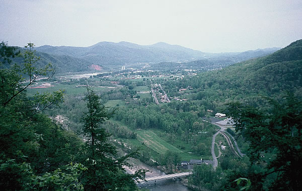
I was now getting close to Hot Springs, another small town situated on the French Broad River and only 40 minutes north of Nashville. It was another popular place for hikers to rest and eat big. I entered it along a high ridge. Overlooks gave me spectacular views of the river 305 metres below, the Bald Mountain Range and the town of Hot Springs. Lovers Leap was one such Overlook. Supposedly named by the Cherokee Indians, when a maiden of their tribe, Mist-on-the-Mountain, threw herself from the crag after her northern lover, Magwa, was killed by a jealous rival, Lone Wolf. I had no plans of leaping in sympathy as I neared the edge and looked across the valley. I could hear the sounds of rapids below me, but I was unable to see them. I walked on cherishing the views towards town and finally descending by the way of several switchbacks to the river where rapids and the USA Raft Company campsite was located.
Like its namesake, hot springs were discovered at the town location in 1778 by two Indian scouts searching for stolen horses. Being a small town it only had the basics. If you wanted anything out of the ordinary you would probably not find it there. At the first telephone I called Jenny who, like always, was happy to hear from me.
The hostel that most hikers raved about was full, so I had to be content with the Hikers Hostel, which only had three hikers staying there, including road runner Tom. Tom was the only hiker on the trail doing big distances who didn’t have a trail name. He didn’t see it as being important as he was travelling south. After booking into the hostel my priority was to have a good meal at the diner. I filled up with steak, chips, salad, pecan pie and several glasses of Mountain Dew. The portions were huge and the price very fair. One of the waitresses had walked a lot of the trail. She had first-hand experience of what the hikers were feeling once they hit the town, so she looked after them.
At the Outfitters Store I went a little overboard with my shopping. I bought a very expensive titanium cooking set. It had two pots with a lid that could be used as a fry pan if needed. It was very light so that was why it was expensive. I needed to reduce weight so this was one expensive way of doing so. I justified buying it by saying that I had a lifetime of backpacking ahead of me. I walked out of the store with the cook set, a backpack side pocket and some film, which altogether cost me 180 American dollars. I don’t think I’ll mention it to Jenny. Whilst in the shop I met ‘Wombat’ an Australian from Adelaide. He knew the guys I knew, who worked in the Annapurna Outdoor Store in Adelaide.
I collected my food parcel, my video battery charger and a few other items from the post office. It was a good thing that I had sent food because the supermarket had a very poor selection of groceries.
Tom left, so did two other hikers going north, but they were soon back because of heavy rain. I later returned to the diner for a chicken with salad and chips and two beers. Life was good.
Tuesday 5th May
I stayed up late writing, so it was 9.30am by the time I got out of bed. When I started packing I hadn’t realised how late it was, so by the time I dashed down the street to the public phone Jenny had just gone to bed, but I managed to wake her and talk to her.
Before venturing back into the wilderness, I returned to the Outfitters Store to photocopy a 16 page trip update, which I needed to copy five times. It had to be done on his fax machine because it was the only machine in town that could copy it. Every page had to be put through separately and with the store-owner having to serve customers as well, it was an extremely long and painful process. Back at the hostel I weighed my pack before leaving. It weighed 25kgs which was lighter than I had thought. I must have been getting fitter. It was over 28kgs after I shed some weight two days after I left Damascus.
I needed to save money so after having my last cool drink I stepped back onto the steep trail at 4.30pm to find a camping site. It was a glorious day, I had only walked 5kms before finding a shelter with six other hikers inside. It even had a toilet, the first I had seen at a shelter.
Wednesday 6th May
The terrain climbed from 762 metres to 1430 metres high on Bluff Mountain where I rested and had lunch in the hot sun on a pile of large boulders. Here a couple in their 50’s arrived as I was about to take off. They had sold their house in Florida and hoped to move to Virginia to live. Between time they were out to lose themselves in the mountains, to relax, not have to worry about phones or what news was breaking the headlines. It was the first time that the woman had done any backpacking. At the beginning of the trek she didn’t believe that she would make 80kms. She had now completed 354kms and was still going strong. By the time their three months was over, they expected to have walked about 1610kms.

I descended and then climbed to a shelter that was not written up in my guide. Apparently it was going to be knocked down but the authorities changed their mind. I felt quite drained of energy and was happy to get to Lemon Gap where a gravel track intersected the trail. A car was parked nearby with a ‘rich-looking’ couple who had worked for the United Nations in Vienna for four years, eating next to it. My mouth watered immediately. They were bound to offer me a sandwich. I made polite conversation and found out that they were back in the states on a holiday. They continued to eat their picnic salad, chocolate and cool drinks from the boot of the car. By now my mouth was dribbling at the sight, my stomach eager to taste something different from nuts and raisins. I talked long enough for them to offer me some food, but it never came. I walked on disappointed with the human race, took out a few nuts and chewed them slowly. They weren’t that bad after all.
Three miles before scaling Max Patch Mountain 1410 metres, where I was planning to camp on the summit to take in the views, I topped up with water at the Roaring Fork stream. I left the woods and moved closer to a meadow through an archway of rhododendrons. At a small fenced yard the trail moved back briefly into the canopy of trees before coming out on the northern side of Max Patch meadow. The mountain hump was treeless. The sky looked stormy with black and grey clouds passing quickly overhead with patches of blue sky and the sun beaming through now and again. I walked the grassy hill taking in the views. It felt great to be able to see the waves of mountain ridges fade until the horizon was no longer. Within minutes I was on the top of Max Patch. I wondered how it got its name? It was only 5.30pm and there was still light for at least two more hours but with the incredible view and violent looking sky I just had to spend the night on top. I moved to a place on the southern side where I could see virtually everything around me. To the south, only about 32kms away were the illustrious Smoky Mountains. They were like the Everest of the Appalachians and I couldn’t wait to get there. I erected the tent on this lone hill and took photos.

Camped on Max Patch Mountain and what great views I got.

Whilst cooking, I gazed at the mountains like a teenager looking at his first love. The waves of mountains got taller as they got further away. A rain squall drifted across the sky and passed over in 10 minutes. I could see several more storms on their way with windows of clear skies between them. I waited and sat in the doorway of my tent watching the mountains and the flying beetles that surrounded my camp. It turned colder with every 30 minutes that went by but I added layers of clothing to counteract it. The rain squalls continued and the tent shook violently with the wind but I loved facing the elements. It was going to be a cold blustery night but I had the best equipment to be cosy. As it became dark a lonely twinkle of light sparkled in a valley. I watched it come and go as the rain sailed by in waves. This was my mountain for that night.
Smoky Mountains – Thursday 7th May
At 7.00am the rain had stopped, the mountains were hazy and clouds filled the valleys. The strong wind soon dried my tent but I could see more rain sweeping across the ridge. Rain followed me down into the woods where the forest penned me in again. Nearing Brown Gap mist moved in making it hard to see which way I was headed. By 11.30am I reached Groundhog Creek Shelter to have lunch. As I climbed and descended for the next two hours I met eight hikers, including a girl hiking in bare feet and a woman with an Alsatian dog.


I descended out onto a highway, crossed a bridge and beyond the Pigeon River rapids I saw a sign to Mountain Mamma’s. Hikers had talked about Mountain Mamma’s hostel and the great food but I was not lured to go there. I kept walking along the trail to where it became steep and skirted a waterfall. A powerful gust of wind blew up the gap, dislodging a branch from an overhanging tree that fell onto my pack. A few seconds later another larger branch spiked the ground at my feet. Lucky to be alive I followed the cascading creek up the hill to where a 45cm snake was slithering along the path. It was too small to be of harm.
I was now beyond Davenport Gap and in the Great Smokey Mountains National Park and it showed as the trails were very eroded because of the horses that were allowed to use them. Horse’s hooves had dug deep into the trail, creating a well-worn channel sometimes over a foot deep. A river of water flowed freely ensuring the channel would only get bigger. The channel was too deep for the water to trickle into the forest as usual, so it just headed straight down the hill. Mud squelched under and over my boots. The narrow channel made walking that much more difficult. I cursed the horses and the authorities who allowed them to be there. Debate rages about allowing horses into sensitive areas such as the Smoky Mountains. The rangers who are there to protect the area still want to use horses to service the huts and look after the network of trails in the park. I suppose it is the easiest and most romantic way to get around the mountains.

The highest point in the Smokies is Clingmans Dome, which rises to an elevation of 6,643 feet (2,025 m).
The mountain is the highest in Tennessee and the third highest in the Appalachian range.

The Appalachian Trail (AT) travels 116 kilometres through Great Smoky Mountains National Park along the Tennessee-North Carolina border.
On the southwest end, the trail crosses into the park at Fontana Dam, ascends up to its highest point at Clingmans Dome and back down in elevation in the northeast area of the park where it exits at Davenport Gap. Along the way, the trail only crosses one road at Newfound Gap.
Davenport Gap Shelter was a welcome relief from the muddy climb. Not only did it have a toilet, it had a wire fence around the front to protect hikers from bears. A gate allowed hikers to get in and out but it was closed to make sure that bears didn’t get in. Hikers heading north complained that the cages around the Smoky Mountain huts took away the wilderness feeling. I soon came to agree. I had reached the hut just in time. A storm had developed and hail stones nearly as big as golf balls hammered the shelter and the repeated thunderclaps sounded like blasting was taking place in the nearby mountains. Eventually after the ground had turned white, the hail stopped but the storm continued.
A hiker resting inside the hut in his sleeping bag was suffering from a spider bite. Two other hikers who were camped in the hut had walked down to Mountain Mamas for a feed and they returned later to the shelter drenched and cold. They kept talking about Eric Wooldolf, a dangerous killer and one of the most wanted men in the US who was supposed to have been hiding in the area. They were sure that they had seen him on the trail. His picture and reward was pinned up in most shelters throughout the Smoky Mountains. Tom had slept in the shelter the previous night so he wasn’t that far ahead of me.

Davenport Gap Shelter.

Packs are hung from the rafters with rope and cans are used to stop mice from climbing down.
Friday 8th May
Four different owl calls continued throughout the night. Apart from me, ‘Lost Okie’ an old guy from Kentucky was the last to leave. He was so proud of his breakfast cereal called grits, and he insisted that I tasted a bowl full. To me it tasted like ground corn, although it was his favourite, I didn’t take much of a shine to it.
The trail climbed for several kilometres before levelling a little near a large rock and a clearing that gave me great views to the north. Beyond the summit the terrain levelled further and the trail curled around the side of a mountain. To my west the gully dipped several hundred metres before rising to the next ridge. I met three hikers before reaching a hut and had lunch at the hut with two young guys who were still at school and using the walk as practical experience. Back on the trail I met another three hikers on a bend on a flat part of the trail who were about as old as I. We talked briefly and I told them of my plans. Bill who lived near the Mississippi River gave me his address. “If you come through Burlington, please look me up,” he said. He seemed very genuine, so a few months later I took up his offer.
I ascended another long hill, it became misty, then rained lightly. The wind whistled through the trees and then it hailed. There were piles of hail scattered around the mountain and in some places it hadn’t melted because it was too cold. Beyond the next summit the rocky path became more eroded and muddy. As I walked the downhill slope in the later afternoon, I was happy to see smoke which was coming from a hut chimney and drifting into the mist. Two horses were tied up nearby. I pushed the steel gate open and entered. Two locals were hanging their wet clothes and boiling a hot drink. A ‘thru hiker’ was warming in front of the smoky fire.
The hut soon started to fill with hikers. On days like this, when the weather was absolutely atrocious, getting a space in the hut was like staying at the Sheraton. I was glad I was early to pick the best spot and not have to erect my tent. A couple either in love or at least acting the loving role arrived next. They were all over each other. It was actually pretty sickening to watch because it looked as if they were putting on a show for the audience and the woman was acting more like a four year old and being very silly. Another two lone male hikers arrived, and then an elderly couple from Kentucky.

Bunk beds in a shelter.
The wind and rain howled outside. Hikers readied themselves for a long night. Steam was coming from cooking pots and water dripped from the wet hanging clothing. The raised boards in the hut used for sleeping on were now completely covered with dirty socks, clothing and hiker’s packs. There was a stench of smelly feet drifting around. The hut was full of activity when suddenly shouts were heard over the noise. Immediately the place went quiet and then a rush of people put on their boots and fled outside, fanning out amongst the mist. Our group called back and within minutes a hiker, wrapped in his Gore-Tex jacket walked out of the mist. The man, who was in his 30s, had lost his partner in the mist a few kilometres back. He thought his friend may be ahead but he wasn’t quite sure. He just kept shouting in case his friend could hear him. It was lucky for him that we heard him, as he had walked by the hut without seeing it. The mist had reduced visibility to a few metres and the rain made things worse. Somewhere however, his partner was still out there. The group decided to wait a while to give his friend the chance to arrive, which he did just ten minutes later, much to the relief of his mate.
As darkness started to set in and the rain continued to fall, a young, fit looking woman arrived, drenched to the bone. We welcomed her with open arms and were really impressed when she said she had walked almost 42kms. The hut was now full of wet bodies and soggy hanging clothes.
Saturday 9th May
Hikers were scrambling around in the early morning darkness packing up to go. Torch lights flashed around the hut like searchlights in war time. It was still dark when some left. I wasn’t that keen, I dozed until I could see some light filtering into the hut. ‘Rabbi Yogi’ and partner ‘Alice in Wonderland’ were still there when I left. I renamed the woman ‘Alice in Cuckoo Land’ as she was always giggling and being silly.
It had rained all night but it had now stopped, leaving the morning misty and my climb up and down the knife-edged ridge a risky venture. There would have been fantastic views if it had been clear. Unlike most of the forests so far, the Smokey Mountain National Park had many trails. Almost 116kms of the AT goes through the Smoky Mountains but there are hundreds of other trails in the park. Many hikers become lost due to them taking the wrong trail. There are 12 of the 18 shelters, and 46 of the 98 backcountry campsites in the park that will accept horses. The Great Smoky National Park was established in 1934, and with over 9 million visitors per year, it is the most visited National Park in the US. The name ‘Smokey” comes from the natural fog that often hangs over the range and from a distance presents as large smoke plumes. This fog, which is most common in the morning and after rainfall, is the result of warm humid air from the Gulf of Mexico cooling rapidly in the higher elevations of the Southern Appalachia.
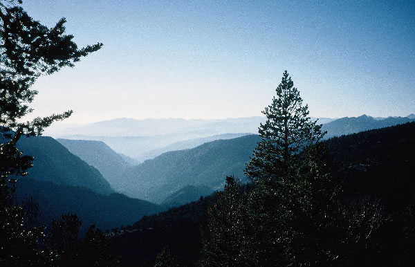
Smoky Mountains.
Near Pecks corner I met a hiker who had lost his male hiking partner ‘Atom Ant’. Apparently he had somehow taken an offshoot trail and just kept walking until eventually figuring out that he was not on the right trail. Two partners in two separate incidents separated from each other in two days. There must be a message in this somewhere!!
When the mist cleared I could see the knife-edged ridge and the valleys and mountain ranges around me. The beauty of the Smoky Mountains was being revealed as I came closer to Newfoundland Gap. The track was still severely eroded with mud holes and in many places it was extremely steep. Fallen trees growing on rock shelves showed their shallow root systems. It’s no wonder they fall over, as there was nothing to anchor them to the ground. At Charlies Bunion there were several day trippers on the rocks. Some were wearing harnesses, helmets and carrying ropes assumingly going rappelling. Several clearings along the trail enabled me to see the views and hill climbs to Icewater Springs Shelter. I learnt from a woman hiker, who was resting there, that Tom had hitched to Gatlinburg, a town to the west of the mountain range.

Smoky Mountains.
Day trippers were increasing in numbers, due to a major road crossing at Newfoundland Gap. Lovers were kissing and hugging on the trail, mums and dads were dragging their kids along and telling them it would be good for them to walk. I didn’t need a trail to follow as rubbish, and lolly wrappers created their own trail to the road.
Newfoundland Gap car park was overflowing with cars. Tourists stood by a stone wall looking at the fine view to the east. Day hikers gathered around me and wanted to know what I was doing. For a moment there I was the centre of attention and I felt like a hero. The urge to stay, to mingle and to eat ice-cream was pretty strong, but my will to keep moving was stronger. A few miles further Mt Collins hut was situated 600 metres off the main trail, a diversion that I didn’t usually appreciate at the end of the day but it was time to rest up. Three hikers were already there and six more arrived later. A creek, about 200 metres from the shelter gave me a great chance to soak my feet.
Sunday 10th May
An alarm rang out in the darkness of the early morning, but no one bothered to get up. When I started to move at 7.15am everyone had the same idea so chaos reigned. Squirrels scampering around, searching for food scraps, amused us while we were packing. Back on the main trail the muddy holes and rough terrain led me to Clingmans Dome, the highest point on the Appalachian Trail, 2024 metres. Tourists were scaling a lookout tower, but nothing could be seen in the complete white-out, only the cloud and rain. There was no point in stopping, so I moved on to Double Spring Shelter situated in a small grassy meadow along a ridge. The rain pelted down so I took refuge for 40 minutes and put my leggings on. I left the hut and within minutes the heavy rain stopped, allowing me to see the views of the mountains through the trees. By 4.00pm the day turned sour again. Derrick Knob shelter became my saviour for the night. It was really too early to stop but the weather was too hostile to go on, and the next shelter was just over 10kms away, a little too far to walk in this wintry weather. I boiled water and made a cup of hot chocolate.
Then at 5.45pm two young 19 year old college students Brett and Alan arrived at the three-sided shelter which was complete with a wire fence to keep bears out. They were hiking in their holidays. It was raining extremely heavily and they were soaked to the skin. Brett, who was only wearing a T-shirt, was shaking with cold and fatigue. He hadn’t done much hiking for a while and he was a little overweight. They had no pack covers, so their gear inside, including Brett’s sleeping bag was between damp and wet. They lived 320kms apart, but became friends at college. They were both in the Boy Scouts and held an Eagle Award, the highest award you can achieve. They came out here to relax, yet they arrived at the shelter totally exhausted. Brett said his parents earned $110,000 a year but didn’t do anything active, whereas Alan’s parents, who were not wealthy, had cycled across Virginia and loved the outdoors. They hung their wet clothes and started cooking on their slow burning stove. Before eating their meal they said prayers and then before going to sleep they read passages in the Bible. It was quite an eye opener and good to see that they stuck to their values even away from the pressures of people and parents. I thought these two trainee engineers would sleep well that night.

Monday 11th May
The next morning, Brett said he didn’t sleep too well as he was sore all over. I didn’t know how he was going to cope with a 22.5kms day. I felt sorry for him. He had the will and inspiration to get away in the mountains when all his class mates were probably at the video arcades, but now he was hurting. I hope he finishes the walk with a positive frame of mind.
I left them and walked along the misty muddy track tackling ascents and descents, passing grassy summits and rocky tops reaching Spence Field Shelter for lunch. There was a sign saying ‘bears active in this area’ but all I could see were two dead mice outside. Apparently there were 1,500 bears in the park but so far I hadn’t seen any. Then just as I thought that bears didn’t exist, I met four hikers further down the trail who had seen a bear and two cubs at the nearby fire tower. I was all pumped up with excitement and ready and firing to meet these beasts within the hour, when I suddenly heard noises of a large animal in the woods. I stood still and waited for something to appear. I had already decided it was going to be a bear, when a lovely placid deer walked towards the trail only six metres away. I was disappointed, but a little relieved. Two other deer were grazing nearby and when I clicked my camera, the nearest one ran away. The others just scratched and kept grazing.
Almost 10kms further I reached the fire lookout tower. I had been searching the forest for bears along the way and I really, really wanted to see them. I dropped my pack and climbed the tower. The view from the top was perfect. I was high above the trees and I could see for miles towards mountains, forests and the Fontana Lake. After such varying weather conditions over the past few days, this incredible view was welcome and enhanced my impression of the Smoky Mountains. By nightfall I would be out of the national park. I was bouncing with excitement as I climbed down. Seeing a bear would really top off my day.

Fontana Dam.
It was downhill all the way to the dam. Before moving I checked my left foot and taped a hot spot that was about to develop into a blister. Further along, the track was dotted with deer foot prints. They looked fresh so I carefully tried to be quiet. Then standing before me, grazing on the trail were two deer. They moved off when they saw me and stood in the forest and between chewing mouthfuls of grass, kept a watchful eye on me passing.
Between the trees I could see the lake and the last of the afternoon sun shining on it. I wanted to get down to it before the sun’s reflection disappeared, so I hurried into a trot to a bitumen road that lead to the Fontana Dam wall. The dam was one mass of concrete and rubble that held back the water and generated power. The generators were working and the river was flowing well. The spillway, although not running, looked like a huge laundry chute. Repairs were being made to the dam but the workmen had gone home as it was late. The dam was deserted and the shop closed. I walked up the road towards a shelter which was one of the newest on route. Picnic tables and a small camping area were close by. It was 8.20pm and just before dark when I arrived at the shelter after completing 36kms, the best day so far. The three people in the shelter told me that Tom had left at 2.00pm that day. Damn, I missed him again!

Fontana Dam Shelter.
I was later told that a couple who were staying at the shelter used to stay at each shelter for several days and sponge off other hikers. They claimed to have little money, yet they smoked heavily. They talked constantly and lay in bed long after most people were up. I was glad to leave this couple behind.
It was a still evening with no rain, no cloud, and the moon came up. There were boats on the lake and I could see the lights.
Tuesday 12 May
Mice were racing around the shelter in the night, over my bags, across the floor and at one time across my head. Hell knows what they were doing when I was asleep! If I had my stick close by, I would have belted them. To top things off, two people arrived at 2.00am, waking me up.
There was slight mist in the mountains but I could see the lake from my bed. I was out of the Smoky Mountain National Park so there was no cage around the shelter which was much better. Tables and benches outside allowed me to eat breakfast in style. It really was a little more up-market than all the other shelters. Two hikers Garry and Scott who had camped nearby overnight were leaving with their black Labrador dog. I had a brief talk with them before they walked off into the forest.

Gary & Scott
For me it was time to have a few hours’ rest, collect my food parcel and replenish my supplies, but first I showered at the dam ablution block, which was a few hundred metres away. There were four showers on the same pole. It worked beautifully. At least it did when I worked out how to turn the hot water on. Refreshed, I called Jenny from the nearby phone. She was a bit down and weepy. Her back was hurting, which also caused pain above her eyes. She was also missing me. Jenny was coming over to the states in August and she had just booked her tickets. She would arrive in Denver on the 9th August for three weeks. Before then, she would spend one week in England.
I visited the information centre and they rang the shuttle bus to take me to the village. Within minutes the bus arrived and dropped me off at the post office and shopping complex. Four parcels had arrived, one with my food, one box of odds and ends and video recorder battery charger, one with a T-shirt and another with a Gore-Tex jacket from Elaine. There were no letters or parcels from Jenny.
I claimed a bench outside the Laundromat, loaded my washing and started unpacking and sorting out my food. Elaine had added some goodies to her parcel; a lolly, fig biscuits, chocolate bar, and a small pack of mamba sweets. It was a nice surprise. I bought a cool drink and pop tarts to keep up my energy levels. I was becoming addicted to pop tarts that were iced on the outside. I never ever thought that I would be swayed into living the American way but it was slowly happening. My food and gear was spread along and around the bench. Packing was a slow process, although it shouldn’t have been, but I nibbled my way through an assorted array of foods and goodies whilst I was doing it. The food variety in the store was limited with no fresh food but lots of tourist souvenirs. Again I was glad that I had sent on my food and not relied on the tourist shop.
I charged my video battery in the Laundromat, put all my gear in one box and then sent it off to Springer National Park hoping it would be there when I arrived. By the time I was ready to leave I had consumed three drinks, three ice lollies and lots of other junk food, but it was great after long spells without them.
The free shuttle bus dropped me off near the shelter. The weather was glorious and Fontana Lake was spectacular with ripples shimmering across the water surface, as wind shifts scurried across the open expanse. My walk started at 4.30pm when I crossed the first hill to a boat ramp which was sandwiched between trees and two mountains. A few boats were coming and going. Again the lake looked superb and very inviting. I turned, left the lake behind and headed along the trail. I climbed and climbed my pack heavy after resupplying. I was inspired by a 70 year old and his son who were walking down the trail. I just hope that I can do the same at his age.

Boats on Fontana Lake.

Walking up the next mountain with the lake on the left.

Backpackers camping in the trees.
Up on the ridge a couple of lovers were camped in a saddle. I moved by not wanting to disturb their solitude and deep embrace. I desperately wanted to find a campsite with a view of the lake. I found one but it could have been better, so I left my pack there and ran along the trail for 10 minutes trying to find a better one, and I did. I ran back for my pack and returned to it.
I could see the lake down in the valley, the westerly mountains and the sun setting, leaving a beautiful red tinge in the sky. It was peaceful, the birds were singing and just before dark the forest fell perfectly silent. Not a bird song, not a breath of wind was ruffling the trees. The red glow of the evening sky slowly faded leaving stars to appear one by one, the brightest emerging first. Then the dam lights in the far distance signalled the start of night. Lights also flickered from a few boats on the lake; some were stationary, and others were moving across the water.

I had a great view of the lake and the moon.
After dinner I was in a dream, thinking how perfect the evening was, eating pop tarts, small Snickers bars, drinking hot chocolate and watching the night sky and the lights below. A rustle in the woods startled me and then, seemingly from nowhere, a hiker appeared. ‘Purple Haze’ strolled out of the darkness into my camp. I breathed easier and we talked for a few minutes before he moved off wanting to get to the Fontana Dam that night.
When I retreated into the tent I rolled back the door so I could see the stars and the dam lights and I lay there waiting for the moon to come up over the hill. I didn’t put the tent fly on so I could see and feel the night through the mesh. I wrote my diary by candle light and ate five lollies that I had in my pocket. They would only attract bears to my tent so I thought I’d better eat them, rather than leaving them for the bears to smell. The rest of my food was up a tree. I knew the moon was going to appear, so I waited. To avoid going to sleep I didn’t get into my sleeping bag, so the chilly air kept me awake. I’ve always been passionate about being in a beautiful place watching the moon rise and seeing it tonight would top off an amazing glorious day. I yearn for those perfect times in the wilderness; the great experiences and the solitude and the beauty of the land. It’s what drives me on. It seemed as if I was waiting for hours, thinking, dreaming and nodding off occasionally before the moon slowly drifted up from behind a mountain. It was 12.15am and its glow turned the dark lake into a shimmering sheet of reflective light. The scene was set, and I had realised my goal of seeing the moon rise. I could now let my tired body go to sleep.
Wednesday 13th May
It was another beautiful sunny day. So different to all those wet days that I had been having. Views of the valleys and other mountains appeared through the trees and small clearings. Two hikers, who worked for the World Bank chatted briefly and walked by. Some 30 minutes later their friend, an African American was struggling up the trail. He was still very cheerful, despite the pain he was getting from his ill-fitting pack. He stopped and talked and in the meantime I adjusted his pack so it hugged his body better and fitted him properly. The difference was apparent from his wide smile and gratitude. He walked on with a refreshed bounce in his stride. He was only the third African American hiker that I had seen on the trail.
Just after Brown Fork Gap Shelter I met a few hikers who told me that Earl Shaffer was walking the trail somewhere behind. Earl was the first man to walk the trail in 1948. In those days many regarded his four-month journey as a stunt but today it’s seen as an incredible achievement. The trail wasn’t quite as long then. There is now a lot of mention in books about Earl. Fifty years on and he’s attempting it again. It wasn’t far, perhaps a kilometre or so before Sweetwater Gap Road that I saw this little old man coming towards me. What do you do when you meet a legend! Will he want to stop and talk, I thought, or will he be so fed up of telling his story he will want to go straight by.
When I came within ear shot, I said, “Are you Mr Krueger?” He didn’t respond or quite understand what I said. “Are you Earl?” I then asked. He acknowledged and said, “Sorry, I’m a little deaf.” He probably didn’t understand me the first time because I called him Mr Krueger instead of Mr Shaffer. We started talking and when I told him that I was Australian, he said he had travelled as far as New Caledonia, and had always wanted to visit Australia and New Zealand. He fought in the Pacific during the Second World War on small islands that the Japanese occupied. I asked him his age and told me 79. He said he could never live with himself if he didn’t give the trail another shot, although he didn’t know how far he would get. (Earl finished his third through-hike two weeks prior to his 80th birthday. Earl died of cancer on May 5th, 2002 after a brief illness and hospitalization. He was 83 years old).
He was carrying a relatively small Mountain Troop rucksack, something you would buy at the Army Surplus Stores. It didn’t look like it had a frame. He told me that it was the same one he used 50 years ago. He wasn’t carrying a tent, he always used the huts and if they were full I couldn’t imagine anyone not letting him squeeze in.

Earl Shaffer. The first man to walk the trail.
“Where I come from in Philadelphia the mountains are not big,” he said. “You see clouds that appear to be mountains, but here you see mountains that appear to be clouds, but beyond the haze they actually are mountains, big ones.”
He asked if there were any water between here and the shelter. “No,” I said, “but I can give you some of mine.” “No thanks,” he replied, “I still have a little left, and I’m not one of those blokes who will drink when he gets a bit of thirst.’
“The organisers of the trail day in Damascus said they would pick me up and take me there to share in the festivities so I will probably have a short break then,” he said. I took his photo and shook his hand. He handed me my stick which was leaning against a tree, and said “Never use a stick myself,” and then walked away. After meeting a legend, I now had bounce in my stride. Sadly no one picked him up for trail day so he missed the festivities.
It took only minutes to reach the Sweetwater Spring Road where I met a couple of newly weds (married on March 21st) hiking the whole trail, but I wondered whether they’d still be talking to each other in four month’s time. At the picnic tables near the road a social gathering was taking place. Four more hikers and a family on a drive started having a picnic. “Is this the Eco Challenge?” they asked when they drew in. They had seen the Eco Challenge that had taken place in Australia on the Discovery Channel.
I moved on and at Locust Cove Gap I added 4 litres of water to my pack which weighed heavily on the steep climb to Cheoah Bald. I struggled at times as I climbed the 5000 foot mountain. I arrived there to find three other hikers. Gary (Magoo) and his son Scott, who left Fontana Dam on the morning of my food preparation and another man called Bill, who chain smoked throughout the time I was there. The mountain bald had been cleared on the southern side but it was still wooded on the northern side, where the mountain dropped steeply. The grassy paddock, although sloping, was relatively flat near the summit and a great place to camp. The chain-smoker hid his tent between the trees but I wanted an uninterrupted view across the valley. Gary’s dog was lovely, but very excitable and ran around the mountain top and jumped and scrambled across my $650.00 tent. I could just see the dog’s paws slitting the tent’s fabric. I managed to pretend that I wasn’t worried but I longed for the dog to settle down.
The sun set through a gap in the trees on the western side and before me was a steep drop with a small clearing which allowed us to watch it go down behind the waves of mountain peaks and haze cloud. The night was still. Gary was on his last leg of walking the whole trail. He had walked all the way from the north the year before but sprained his ankle before Fontana Dam. Now he had returned to finish the last stretch and complete his very long journey.

When I started my walk the trees were virtually leafless, now four weeks later and 515kms further south, the forest was totally green and the birds were very active.
The weather had radically improved with several days of sunshine and the expectation of more to come. It meant I could see the views from the mountain peaks instead of the mist or rain and it certainly helped the walk to become more enjoyable.
Thursday 14th May
Gary and Scott were ready to leave at the same time as I, so I followed them down the trail. Gary’s dog, which was at his heels and kept tripping Gary up, but he didn’t seem to mind. The dog was eager to pass but the trail was too narrow. At Sassafras Shelter, a school group had left the fire burning. It was there that I decided to leave the guys, as their walking pace was a little slower than mine. I soon caught up with the school group but they all looked so young that I couldn’t pick out the leaders. It was hot and humid, but I was on a downhill slope to the Nantahala Outdoor Centre on the Nantahala River. My arrival at the centre, which had been going since 1972, was exciting but somehow I felt lonely. There were tourists, canoeists, rafters and mountain bikers but they were occupied doing their own things. On the trail the hikers had similar goals and experiences, so hikers had more in common. At the centre, that common bond was partially lost.
I crossed a footbridge to the other side of the centre to the booking office. I booked a $12.00 twin share room at the hostel but I had to wait until later that afternoon to get in. While waiting I checked out the outfitters store and spent more money on four T-shirts as presents, a food bag for hanging in the trees, a buoyant deck bag that I could use on the Mississippi River, maps, a bandanna, film and fuel.
When Gary and Scott arrived we sat at a table on the north side of the river and watched a paddler perform a rope rescue. He threw the rope five times and he still couldn’t reach the girl in the water being rescued. He then tried to take the rope across in his boat, and after several more attempts he finally succeeded. In real life the patient would have been dead. Thank goodness he was only training.
The centre was big on rafting. They not only used local rivers like the Nantahala, but they also rafted the much bigger Chattooga, Ocoee, Nolichucky and French Broad Rivers, which were in the surrounding areas. The Nantahala River, with the exception of one rapid downstream of the centre, looked for most part, grade two. The centre also hired open inflatable kayaks but not closed kayaks. The river itself seemed to be busy with open canoes, hired inflatable kayaks and rafts. Smack in the middle of the centre there was a slalom course for up-and-coming and experienced slalom paddlers to practise. I felt a little jealous. What a great place to own but I knew I was only dreaming as I would never be able to afford such a centre. The centre would be worth a fortune.

A canoeist on the Nantahala River.
It was the weekend of the Damascus Trail Day and hikers along the way had been raving on about it, so I decided to take three days off from walking to go and find out first-hand what a trail day was all about. It was supposed to be the hiker’s social event of the year so I knew I had to be there, as I wouldn’t get another chance to experience the local festivities. I also needed to pick up my bike, which was still in Damascus and take it to the end of the trail. So to do all this I needed to rent a car. Bryson City was nearly 21kms away and although it had a city name it was really only as big as a small town, so hiring a car at a cheap price was out of the question. The round trip from Bryson City to Damascus and back to Springer Mountain, where I would leave my bike and then return to Bryson was about 1,127kms.
Friday 15th May
The guys in the room next door had their fan running all night and it sounded like a concrete mixer. I tried stuffing toilet paper in my ears but it didn’t work. I met Gary and Scott at 8.00am outside the same restaurant that we had dinner in the night before. I had blueberry pancakes with bacon, which I had never had before but it sounded great and tasted even better.
I managed to get a lift into Bryson City, but unfortunately the lift didn’t end up leaving until 1.00pm, because they were waiting to see someone, so I could have walked there much quicker. My rental car was a Ford Escort, I signed the papers and filled up at the first fuel station and was away. A hiker, who I had met on the trail, was on the roadside trying to get a lift. I stopped and gave him a lift to the Maggie Valley bus depot where he took the bus home to St Louis. He said he was on the walk for a spiritual experience, but it hadn’t worked, so after having enough of walking he just wanted to go home.
Highway 19 went smack through a Cherokee Indian Reserve. It was beautiful country but very, very touristy. In fact, at times it became so touristy with huge signs, enormous Indian figures and souvenir stands, that it was just a horrid sight. Every shop wanted to outdo the other. It seemed the bigger, the junkier, the better! It appeared that there were no regulations about signage or respecting the countryside. The Cherokee area was certainly a popular tourist spot American style.
From Maggie Valley I headed to Asheville and onto the Blue Ridge Parkway road and into the mountains. The road was familiar as I had cycled most of it on my way to Damascus but from the other end. For the next 185kms I wouldn’t see any traffic lights. This scenic road meandered its way through the Mt Mitchell State Park, climbing to over 1524 metres high. Mt Mitchell, the highest peak east of the Mississippi River was 2037 metres high. I had no decent food with me in the car so I stopped at a tourist shop and bought some tinned sardines, biscuits, cakes and nuts just to keep me going. The road continued on by Grandfather Mountain, which was so different from all other mountains in the area. Beside the road, climbers were scaling smaller crags. It was a truly a relaxing scenic trip that for once created no sweat or energy depletion, I was savouring the drive. When I turned off the parkway to head towards Damascus, I had cycled or driven all but 225kms of the 756km Blue Ridge Parkway.
I arrived at Damascus at 7.30pm and went straight into a forum and lecture presentation. They had several prominent hikers that got up and spoke about how the AT had changed their lives and near the end they invited people from the floor to speak. I wanted to give some feedback so I stood up and gave a short talk about my experience and the friendliness of the local town folk, especially Damascus and the hikers on the AT. It went down extremely well. They loved my praise, but it was truly justified. Many people came up to me over the weekend and said how they enjoyed my speech.
One of the organisers spoke of Earl Shaffer and how they hoped that Earl would make it there, but when I was talking to Earl, he told me that someone had arranged to pick him up, which obviously never happened. I felt sorry about that. He would have enjoyed the weekend and people would have enjoyed talking to him but he was out there on the trail probably all alone.
When the talk was over, I walked to the camping area where they were selling hot dogs, playing music and outdoor companies were showing their goods. A slide presentation had just started. It retraced the steps and feelings of a hiker. It was very good with some music, some talking and some very emotional scenes at the end. Most people, including myself left with a lump in their throat and a tear in an eye. The crowd was extremely interested in it.
The area was alive with many of the hikers that I had met on the trail, including the ‘Family’ and the ‘Iron Kids’. Then I met the sales manager from Mountain Hardwear. He and a few reps were there showing their products, answering questions about their gear and giving advice. When I told him I worked for Snowgum, in Perth, Western Australia, which was the sole supplier of Mountain Hardwear in Australia, he organised for me to get some prototype gear. Virtually whatever I wanted he would send me. When the night was over I drove to the church, parked up outside and slept in the car.
Saturday 16th May
The church prepared pancakes for the hikers and whoever wanted them. I just got out of the car and straight in the line. I was given a number and a seat. The room was full of hikers, some I knew, others I met there. The pancake breakfast was delicious. It was the sort of breakfast that I dreamt about on the trail. People were still queuing outside when I had finished. More hikers started talking to me and being there was an incredible experience.
The outdoor equipment suppliers were in full swing at tent city informing hikers of the benefits of their products, and replacing products that were damaged on the trail. I listened to the MSR female rep explaining the MSR stove. She was red hot, not only her looks but also her knowledge. She was one of the most knowledgeable sales reps that I had heard. Purifiers were popular. Virtually every hiker owned one so there were lots of demonstrations and repairs. The Pur filters seemed to be the most popular but they also had the most problems. Sweetwater was also another popular brand.
Staff members representing Gregory packs were also there. They were in the forefront of pack sales. I was so surprised at the amount of packs in America that had external frames and were made of nylon. In Australia and New Zealand internal framed canvas packs dominated the market and it was hard to find an external framed pack other than in an Army Surplus Store. Just by looking at a hiker’s pack you could pick out the foreigners. Most of the American packs were lighter but not waterproof so hikers had to carry waterproof covers to keep their gear dry. Canvas packs were regarded as waterproof although in heavy rain water droplets could penetrate the fabric.
Mountain Hardwear were relatively new in the outdoor market place but they were already big players and had developed a great range of quality gear. A lot of my gear was made by Mountain Hardwear and I talked to many hikers on the trail who swore by their gear.
I walked to the park for lunch as this was where the music was playing and all the action was to be taking place. There were many food stalls including one called Australian Alligator. The food that they were serving definitely wasn’t Australian, and who’s heard of an Australian Alligator? Then, there were the T-shirts, souvenirs, and leather goods stalls. You name it, it was there. I passed up the chance to have a dish from the Australian Alligator food stall and ordered a baked potato with sour cream instead. With a slightly full belly I walked back into town to check out the outfitters store and collect my bike from the bike shop. Bill had been storing it for me during my walk and I really appreciated that. I thanked him and took it apart so I could get it in my small car.
The crowd was building up along the main street. The big event of the day was going to be a parade that included hikers, scouts and whoever wanted to join in. The parade started to head along the main street led by the organisers, then the scouts, flag-waving girls, bands, old cars, and then the hikers, and there were lots of them. The hikers however, became the target of water bombing by the locals on the pavements. The locals threw water balloons and used huge water pistols to cool the hikers. The water pistol gang then turned on themselves and all hell broke loose.

Hikers parade at Damascus Trail Day.
Sweets were given out to the kids or whoever held out their hand or caught them flying through the air. The fun continued all the way to the park where the crowd fanned out and a memorial service was held. Unfortunately most of the crowd was revved up and excited, so they took little notice of the service.
A South African hiker kindly bought me a beer and a baked potato that was oozing with sour cream. I was just about to eat it when I was approached by a guy who had heard that I was going to paddle the Mississippi River. Noel had taken the opportunity to search me out as he had paddled the Mississippi and was happy to share his knowledge of the river with me. Both he and his wife were extremely helpful. Noel had maps and other information that he said he would send me when I was on the river. When he paddled the Mississippi he did so in an open canoe and he told me he had also walked the full length of the Appalachian Trail so he had conquered two of America’s great physical tests. It’s always nice to talk to people who have a similar outlook to physical challenges as myself.
Back on stage the talent contest was in motion. Hikers took it on themselves to entertain the crowd by the way of songs, poems, music or whatever else they wanted to do. The John Denver song, “Take Me Home, Country Road, West Virginia” hit an emotional spot, when it was sung. I had been singing it on the trail. Then ‘Wombat,’ whose real name was Alistair, an Australian walked on stage. He started singing a love song that he composed about his relationship with a fellow hiker on the trail and how he fell in love with her. He was surprisingly brilliant, as he had no music to help him along and it was the first time that he had sung or done anything like it before. The crowd loved it, in fact some women even cried. They must have thought it was totally true. It was really a mix of fact and fiction. ‘Wombat’ came and talked to me later. He said he was very nervous and that’s why he had his hands in his pockets. I hadn’t noticed. Two girls came up to us and told him he was great. Others asked whether he and the girl from the song were getting married. He became the talk of the town. His partner in the song had shaved her head. Many of the hikers either shave their head or dye their hair. Others shaved the letters AT in the back of their head.

Backpackers take to the stage.
I had a fried dough thing with apple. I had no idea what it really was but it tasted okay. People continued to come up to me to wish me luck or just to say, “I saw you on the trail.” Most I didn’t recognise.
There was a slide show on at the church hall so I thought I would check it out. The presenter showed six different group trips that he taken along the trail. His group carried day packs and had a support team. They were on one big bonding session. The show was pretty deep, it really wasn’t for everyone, and then at the end he asked the audience the meaning of the slides. I soon lost interest.
When I left and visited tent city, Mike and the Mountain Hardwear guys invited me to dinner. Dinner was delightful, we had beautiful salmon and salad and talked over a beer.
Sunday 17th May
I slept in my car again and woke up at 6.50am and began driving by 7.00am. My memorable Damascus Trail weekend break was over so I drove the winding, foggy minor roads through the mountains for the first two hours and ended up feeling car sick, so I returned to the major roads and began to make better time. I drove through Johnson City, Erwin, Asheville and a small town of Dahlonega where I paused for a while to look around the market stalls. I had travelled for kilometres but the scenery was still beautiful with many forests and mountain ranges.
I arrived at Amicalola Falls State Park, which was at the end of the Appalachian Trail and left my bicycle and a box with all my cycling gear with Jennifer, a park ranger. After a walk to the spectacular falls I returned to Nantahala Outdoor Centre via Ellijay, Blue Ridge, Murphy, Andrews and through the gorge following the Nantahala River. To save a few dollars I slept in the car in the car park.
Monday 18th May
It was Monday May 18th and a special day because it was Jenny’s birthday. I drove to Bryson City to return the car, which cost me $165.00 for the three days and then I hitch hiked back to Nantahala getting three lifts and doing a few kilometres of walking. One of the drivers told me that there was going to be a civil war soon. “There are so many immigrants going on welfare or stealing our jobs that the militia groups will rise up and start fighting. I can’t blame them,” he said. “The states are being over-run by them.” He dropped me off and I was relieved to get out of his car. My last lift took me to Nantahala. I thanked the couple who dropped me off and as we were talking, Sherry, the centre manager recognised my Australian accent and told me that she had secured the job of managing the Olympic Slalom & Whitewater Course in Australia. She had organised slalom kayaking at the Atlanta Olympics.
It was then time to leave, to head back into the woods like hikers do, but before doing so I ate six bananas, two Pop Tarts and downed a Mountain Dew drink. I was reluctant to leave as the sun was still shining and the centre was so relaxing. Three days with no walking had spoiled me. However, time came to climb the steep hill and continue my journey passing more huts and a fire tower that gave me sweeping views. I found a hut and camped with a couple, Gerald and Janet and a lone woman hiker, who’s name I didn’t catch.
There were some really courageous and incredibly interesting people on the trail. One day I met six women each travelling along the trail alone. This trail is not just for men, there are heaps of women walking it. Most are paired up, although many love to go solo. The majority are young, fit and have the figure of a racehorse. Others are chunkier, less fit, and slower, but nevertheless they have the same aims and always get to where they want to go. For women though there is always the added danger, not from other hikers but from the general public. Two women were murdered in the Shenandoah Mountains a couple of years ago.
Tuesday 19th May
Thank God I slept okay because Gerald’s snoring was bad. As I was leaving, Gerald and Janet were discussing the day. Gerald only wanted to do 5-9kms and Janet wanted to go all the way to NOC nearly 14kms. I left them to fight it out.
I stopped briefly at Cold Spring Shelter. It was the first shelter I had seen without a raised floor. There were several campsites around. Walking to Burningtown Gap and Licklog Gap was easy going but then I had to climb to Wayah Bald. A structure, a rock fire tower greeted me. Three people were at the top when I arrived. I felt fairly buggered, but I climbed the stairs up to the blue metal floor. It felt more like a Fort’s Watch Tower. The view east was hazy. Many trees were red and orange. The man and daughter in the tower kept calling me sir. The young couple below were hiking for six days to test their equipment because they were going to walk the whole Pacific Crest Trail which is supposed to be harder and longer than the Appalachian Trail.

Wayah Bald Lookout.

I passed five hikers by the time I stopped at a campsite. I had a wash, washed my hair and cooked rice pudding. It didn’t taste quite as good using skim milk powder. In Australia we have creamed milk powder which tastes really good, but I hadn’t been able to find in the shops in the US.
Wednesday 20th May 98
As I stood next to my tent considering breakfast I heard a creak and watched a solid 5 metre branch crash to the ground and across the trail only a few metres away. The entire 18 metre tall dead tree shook and wavered as if it too was about to fall.
Two brothers Richard and Noah, whom I had met previously, stopped for a chat as they passed. An hour later I met them again at Winding Stair Gap on the new US64 Highway. They said a friend was picking them up at the highway. I filled up from a black water pipe that was discharging beautiful spring water. The pipe was two metres high and a great height for a shower. Before leaving I mentioned to the guys that there were two US 64s roads, the old and new. They were waiting on the new. I left the brothers from Knoxville and made my way up the hill. Within 10 minutes I saw a man on the other side of the creek just about to leave his camp. I shouted good morning and he shouted back, “Are you Wanderer? I’ve heard so much about your exploits,” he said. Who had he been talking to in this remote forest? All the hikers were going north and wouldn’t know of me.
“Stay there,” he said, “I’ll come across and shake your hand.” I waited and when he got to me, he shook my hand firmly. “I’m Ghostrider,” I thought he said. He was wearing Royal Robbins shorts, photographer/hunter type jacket full of pockets, and a trilby hat. He looked more like an English gentleman rather than a hiker. He started talking about the King Ranch in Texas, then about the Jews having a sabbatical, one year off in every seven. He was a farmer who worked hard all his life and reckoned he was owed seven year’s leave. He had a friend who owned a computer company and was just about to sell it for seven million dollars. Then he had another friend who just died of cancer and now he wished he had made the effort to spend more time with him. Now it’s too late. Every few moments he paused before spitting and then started talking again. He was possibly going to get married. I didn’t dare ask for more details. He loved playing poker, and when he and his rich friend got together, that’s what they do.
He was hiking south, but missing certain sections. He had met Tom and it was he that had told him about me. I said goodbye to him several times but he always managed to bring up another subject. Richard and Noah came walking along the track and thankfully, rescued me. After I told them about the two roads, they thought more deeply about the road they had arranged to meet their lift. Now they were sure that it was the old US64 and not the new.
I led the way across the mountains, being only the second time that I had walked with someone for more than an hour. They started giving me a history lesson, which was great. They told me that the civil war was started by the Confederates firing on Fort Sumter, a government fort at Charleston, in South Carolina. They reckoned that the south had better generals. They then told me about how the Cherokee Indians were marched away from the Smokey Mountains to Oklahoma, by the Tennessee government. It was called ‘the road of tears’ because many died along the way. The last of the Georgian Cherokees were forced to leave in 1838.
We reached Wallace Gap, the old US64 where my new friends would wait for their lift. I had learnt so much about American history in our short time together, so it was disappointing to have to part company. Before walking on, I rested and ate a few nibbles with them. Then ‘Ghost rider’ walked down the hill and started talking incessantly again so I left them to it, smiling to myself as I walked off.
I met two women who were lost and then fourteen college students as I made my way to Albert Mountain Tower. There were reddish trees over to the east but I didn’t know what tree they were. On a steep descent I met two hikers who had their knees strapped for support. I didn’t fancy their chances of walking far.
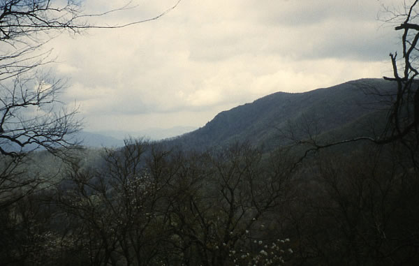
I found a spring, and filtered water. Two guys, one from New Jersey and the other from Dallas were wondering how I got the time off work to do such a long trip. Unlike Australians, most American workers were only allowed two week’s annual leave, that’s unless they had worked for the same company for years. I met several people who were using their yearly two week’s holiday walking the trail. Before they got another two weeks, they had to work another year. Two week’s holiday a year seemed so little. By nightfall I had reached Beech Gap and camped having walked just over 32kms that day
Thursday 21st May
When I left to start my climb up to Standing Indian Mountain it was the earliest I had set off yet. I reached the hazy summit just as four men who had camped there were leaving. They said they expected a storm to develop. As I descended to Deep Gap I passed 7 hikers and a fairly new shelter. At the gap, a vehicle which had dropped off 4 hikers was being driven away and within minutes they allowed me to pass after I had caught them up. By now, with my improved fitness I was making good time but an hour later I got a big surprise when I heard voices coming from behind as I approached the Muskrat Creek Shelter. It was hard to think that a group could be walking so fast that they were able to catch up with me. I turned and it was the four guys who I had passed earlier. They had increased their pace and I noticed that they were running down the track. I stopped to check out the next shelter, they had done likewise and we talked. Three of them were army rangers from Dahonega. They carried huge, and I mean huge, machetes and revolvers. They joked about their weapons. Thank God they were the good guys!! One soldier had an enormous deer meat sausage, like a polony roll that looked as big as a bazooka, hanging off his pack. It was as long as his pack was wide and at least 6 inches in diameter. I hadn’t seen anything like it before.

Army Rangers and friend.
I was surprised to see them carry ill-fitting packs. I thought the army would have better gear. The toughest looking guy, who was built like an overgrown bull, carried a short but wide pack. He had carried it for years, he said. It looked extremely heavy and awkward to carry, so I asked if I could try it on. When I put it on, it felt terrible, all the weight seemed to be low and too far out from my back, so as I moved it was trying to pull on my shoulders and drag me backwards. He said, he was used to it, so he didn’t notice. The weight needed to be close to the body and much higher, I told him. I can imagine though, that when on patrols in the forests they need a lower pack so they can duck under trees. There must have been some reason for carrying such a pack. I let them try mine and they just couldn’t believe how comfortable it was, and realised what they were missing out on. The army seemed so out of touch with the best equipment. The other three packs were more modern but the guys didn’t have them adjusted right, so I adjusted them and they instantly said their packs felt better.
The older, bearded man was a civilian. He ate a muesli bar, moved across to the fire and put the foil wrapper under a rock in the ashes. I was waiting for his mates to say something but they didn’t, and not wanting to upset the apple cart, I said nothing too. Most hikers saw foil wrappers as burnable rubbish, but I didn’t and so it was common to see foil in fireplaces which I was a little annoyed about, but I couldn’t do much about it.
Dahlonega, where the army guys were based, was the site of the nation’s first gold rush in 1828 beating the California gold rush by two decades. They continued telling me a little more trivia saying that Atlanta was reduced to ashes in 1864 by General Sherman’s troops during the civil war, and after it was rebuilt it became the capital of Georgia. Georgia was named after King George 11 of England and two famous people, Jimmy Carter and Martin Luther King were born in Georgia. My knowledge of American history was rapidly increasing. I was now on a mission to find out as much as I could about the country.
After an interesting meeting, the four took off like rockets. They were virtually jogging going down the hills but I caught them up a little on the climbs. They now seemed like men on a mission. I suspect that being in the US Forces’ elite squad they hadn’t taken too kindly to me passing them on the trail, so now they were showing me how real men hike.
I kept on the move thinking that I would never see them again, however, almost 5kms further, at Bly Gap, near the border of North Carolina and Georgia I caught up with them. I felt somewhat smug as their strategy to get ahead hadn’t worked. Two of them had their boots off and were repairing their blistered feet. I couldn’t help but feel a little pleased with myself as it was like the story about the tortoise and the hare. I stayed long enough to have a short chat and then moved a little further to a creek to filter some water. They arrived at the creek just as I was going. One guy reckoned that they should carry six quarts of water (over five and a half litres) which is a lot of water when they are able to fill up from creeks every 16kms or so. Although they were hiking the same route as I was, I never did see this elite squad again. I suppose they just couldn’t keep up with my pace!!

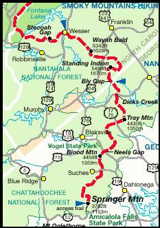
From Fontana Lake to Amicalola Falls State Park 273 kilometres.
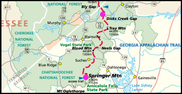
I moved across the Georgian border and met a man and his dog who both were looking shattered. I heard a loud animal sound scrambling through the bush but it was soon gone. I reached Plum Orchard Gap Shelter and with the increasing warmth of the days, the mosquitoes, ants and black flies were becoming a menace. I chased beetles along the trail. Some of them were mounted like they were having sex and when they heard me approaching, scuttled for cover. Then there were small caterpillars hanging on threads from trees. These were suspended at different heights along the trail and were impossible to avoid. The ones at head height were the worst and they got in my hair and on my face. They collected on my pack, on my head and shoulders, and by the end of the day, I was covered with them.
I was now doing 32–40km days. The end of my trip was getting near and my fitness was peaking. Although I started off steadily, I was happy with my performance. I mean I was 47 years old. Some days the heat caused some distress. I started to chaff around my backside area. I tried walking without underpants to see if I could stop it, but my wobbly bits, wobbled too much and it didn’t improve. Luckily I had experienced this before on hot hikes in Australia, so I carried cream to prevent it. A little placed in the crater of the bum soon helped to reduce the discomfort. I then became a happy chappie once more!
The forest had really changed since I had started my walk. The trees were full of green, and rhododendrons were blossoming. I met photographer Bart Smith, who had produced photos for a book on the Pacific Crest Trail, and now he was doing one on the AT. He had his tripod set up and he was waiting for the sun to shine directly on a flower.
Friday 22nd May
The night had been full of rain, there was also lightning and it was very warm. I met a young guy down the track who said he had seen a bear. I walked by Deep Gap Shelter, Sassafras Gap, and then I ate jerky at Tray Mountain Shelter. Beef jerky had become one of my favourite snacks. At the top of Tray Mountain I took photos of the rhododendrons in flower. Caterpillars hanging on threads from the tree branches had disappeared for a while but now they were back. I met two young girls and then their mums so I thought that the track ahead of me would be clear of the threads as they had just walked that way, but disappointingly they were still there.
I struggled up the steep Rocky Mountain meeting a few more hikers before reaching the top where the view down one side of the valley was really quite special. I descended a stream taking the opportunity to filter some water. When on the climb again I met two different couples who were walking with dogs. A road was close so there were many more weekend walkers on the trail.

Dogs were often seen on the trail.
At Blue Mountain Shelter I caught up with Kirk whom I had seen at Hot Springs and who lived near the Mississippi River. He threw me a beer but it dropped short and punctured. I quickly retrieved it and drank from the small hole that the beer was spraying through. As soon as it had lost its fizz I was able to take a good mouthful. It was unbelievably welcome after such a steep climb and days of drinking only water. I can’t imagine why Kirk wanted to carry a dozen beers up a mountain, but I’m glad he did as the beer tasted pretty good. A couple drinking beside Kirk had met on the internet. They had both wanted partners to walk with, so here they were. The internet is quite amazing. Not only can you find information and goods for sale, you can also find a trail mate. The guy had some serious blisters. He peeled back the plasters and his blisters were red raw. They must have been very painful and I’m sure he couldn’t go much further without letting them heal. I walked on leaving Kirk and the guys to savour their drinks and camped at Chattahoochee Gap where two other tents were erected but the hikers never came out. I collected water 200 odd metres down the slope and then washed. I could see glimpses of the valley through the trees. It was a red sunset. I had walked 32kms up some of toughest hills on the trail.
Down Hill – Saturday 23rd May
The warm night had me sweating and my arms were itching, I wasn’t quite sure if it was a tropical itch or an itch from insects. I had passed a few hikers and a hut and had covered almost 13kms when I stopped to talk to two men. Kirk, who had risen early, caught me up here. He wanted to make the shop at Neel’s Gap as soon as possible, as he only had a few biscuits and some peanut butter left. Neel’s Gap was the last major road crossing the trail before the end. With a shop located there it became another high point of a hiker’s journey. Hikers always wanted to leave civilisation behind but when there was an opportunity to take advantage of it, they were always eager to do so.
We walked together and had lunch at Hogpen Gap sitting on a log next to a stream. I left him to smoke but he soon caught up. For the next few miles we were climbing and descending and passing lots of hikers and boy scouts. The road was getting closer.
After a steep decline we arrived at the stone building and the shop at Neels Gap. The trail went straight through an archway of the building, so hikers couldn’t get much closer to a shop than that.
I immediately bought two drinks, an icy pole, chocolate and some peanuts. The tables outside overlooked a scenic valley. A major road slicing across the mountain meant that tourists were plentiful with some of them even going for short walks so the trails around the area were more crowded. The shop was air conditioned so I could escape the heat for a short time. It was so cold however, it gave me a chill. The shop carried an extensive range of high quality outdoor gear. Although I had everything I needed I had an urge to buy something but I was too sensible to waste my money and so I resisted the urge. I took advantage of my last store en-route by buying another drink, a cheese & ham sandwich, some Pop-Tarts and a small block of cheese. I just wanted to make a pig of myself.
I returned to the picnic table outside to finish off my latest cache of food and watched a hiker stagger from the trail and cross the road. To my surprise he managed to negotiate it without being knocked down. He looked totally buggered and ready to collapse. He was at least 55, from the big smoke of New York, on his first ever hike.
The Appalachian Trail introduced thousands of people and children to hiking. Most of the ‘thru hikers’ that I met hadn’t backpacked before. This guy had only been walking for a week and he was a physical wreck and about to give up. His answer was to lighten his load so he went into the shop and asked an assistant for help. A young guy came out, put the old guy’s pack on the table and then started throwing his gear into two piles. One pile for things to keep and the other pile were for the things to throw out. The young guy, who probably hadn’t trekked in his life before, told the hiker that he would throw his gear out that he didn’t think he needed, but if he really couldn’t do without it, it was up to him to put it back in. So the throw out pile grew, and his pack got lighter. A large pillow hit the out pile. I didn’t think that I would ever see a hiker carry a large pillow on a long hike. The hiker was really dithering. He really didn’t want to throw it out. He said, “he couldn’t sleep at night without it.” Though he was definitely no child, he reminded me of a child on his first hike. I left before I saw the final result.

A young guy getting advice to how to reduce weight in his pack.
I wandered across the road pausing at a bronze plaque, embedded in stone, with a picture of a hiker. This was my last section before reaching the end. It was almost 50km to Springer Mountain and then another 13km to the Amicalola Visitors Centre. I was excited, I was now walking over 35kms, and I still felt good at the end of it.
Although it was late afternoon, 5.15pm, the ascent to Blood Mountain was hot and sweaty, creating chafing and pain in a delicate position between my bum cheeks. I tried to alleviate the discomfort by applying cream and pushed a spare hanky in my pants to see if it would reduce it. I was a little self-conscious about the bulge, but I would try anything to rid me of the pain and discomfort.
There were several rocky outcrops and rock platforms on my ascent that gave me great views of the surrounding country. Day hikers were also enjoying the summery day near the summit of Blood Mountain. A woman in one group took my photo and I was wondering if the big bulge of my hanky between my legs was noticeable. If she noticed it I wonder what she thought!
The mountain was named Blood Mountain because of a battle between the Cherokees and Creeks, which took place there. A mile further, there was a gap that was named Slaughter Gap. I can only guess at what atrocities might have taken place there. The area around the Blood Mountain Shelter was busy with campers, and a Scout Troop had taken over the shelter. Insects were swarming and although the views were good, I couldn’t imagine it being the ideal spot to bed down, so I moved on to Slaughter Gap trying to get away from the activity. At Slaughter Gap I talked to a few campers but I carried on to Bird Gap where I got talking to three beautiful young women, Courtney, Harden and Jill and for some reason I was persuaded to stop. They were with another hiker, who tagged along named Pete.
Two of them were carrying injuries with fairly serious blisters that I didn’t think would heal unless they stopped for a few days. They were virtually at the beginning of their hike, having only walked 56kms so far. Harden didn’t have a water bag so I gave her one of mine. The chance of them walking for a long distance didn’t look good.

Courtney, Harden, Jill and Pete.
At the beginning of my walk, I wrapped any hot spot that developed on my toes. This was a precaution that I always took when walking and it prevented any full-blown blisters developing. It just meant I checked my feet regularly, washed them and changed and washed my socks as often as I could. This way I kept blisters under control.
The three girls were Christians who wanted to achieve a major milestone in their life. They talked about travel and the goals that they wanted to achieve. They said that my experiences had inspired them further.
Sunday 24th May
Pete was first to leave Bird Gap in the morning. The girls and I were talking a lot so packing was slow. They said that Pete was a millionaire. He had so much money that only a couple of days back he left some expensive gear and clothes in a shelter because his pack was too heavy. Someone finding them must have thought it was Christmas.
Kirk caught up just before the girls left. He searched the ground for a smoke that Pete had thrown down near the log. Apparently Pete had told him it contained some special ingredients!! Having found it Kirk moved on, but I soon caught him sitting on the forest floor a few hundred yards away smoking the stub and looking quite happy. Having never smoked in my entire life, I couldn’t imagine what pleasure he may be getting from it. I had enjoyed life without smokes and drugs, but I don’t think I have missed out?
The woods sparkled and I was mesmerised with my surroundings. I then realised that 95% of the beetles had gone as well as most of the caterpillars hanging from threads, although they did make a return later. The biting flies (similar to our horse flies) were continually menacing though.
Near Justus Creek I washed out my hanky and talked to two couples that told me that someone had shot himself a couple of miles up the track and a guy in a camper van found him. Later that afternoon near Hawk Mountain shelter, I caught up with Gary (who I had first met at Fontana Dam and Cheoah Bald), his son and son’s friend. Gary had sprained his ankle and was having a hard time walking and was limping badly. The following day was the last day on the trail for both of us, but for Gary it was especially important. He would have walked the complete trail from the north to the south. He just had to walk the last 13kms to the summit of Springer Mountain, where his wife would be waiting. It was great to catch up again to talk about what had happened since Nantahala Outdoor Centre. They had already made camp and although I had plans to go further, I decided to stop. They said that a bear had grabbed a hiker’s back pack from the nearby shelter two nights before. It probably wanted to take up hiking. Could you imagine it – watching a bear walking down the trail with a backpack on!
Hundreds of inch worms (small caterpillars) were chewing at the leaves on the trees. We could hear them munching away. It sounded similar to light rain falling. We cooked our meals and shared our stories.
Monday 25th May
The guys were up early before light so I was encouraged to as well. I had used all my water so I ate Pop Tarts and nuts for breakfast. Garry’s ankle looked no better and he reckoned it was going to be a very slow day, but he was determined to get there. We said our goodbyes at 7.45am, the earliest that I had started walking the trail. It would have been great to walk those last miles with Gary but he was unsure how fast he could go and how long it would take. As we parted, I agreed to meet him at his home in Kentucky when I paddled the Mississippi. Kentucky people talked with a southern accent and I was just getting used to Gary’s southern drawl. I found it strange that the Americans referred to the state of Kentucky as being in the south, when compared with all the other states it was more north than south.
Three Forks was a beautiful, spectacular place with cascades, falls and streams running through the area. Hikers and car campers were scattered under the beautiful forest, relaxing and listening to the water falling and the streams gently flowing around their camp. In the early morning light smoke lifted from their breakfast campfires. Some people were reading, others were just relaxing or talking. Most were car campers who had travelled a gravel road to access the beautiful spot. To keep it a little more natural, parking wasn’t allowed near the campsites.
I filled up with water for the last time on the trail but like every drop of water that I had drunk and hadn’t been boiled, it had to be purified. It was a small task but it took time and I found it the biggest pain of the journey. My small Katadyn mini filter was light, but it was slow going in the filtering process, because it was difficult to push water through the small ceramic element. And if I didn’t clean it regularly it would clog and make it even more difficult. There is always a trade off, but it was one of the best filters. Although the water quality looked incredibly clean especially from springs, health warnings about drinking it without filtering were everywhere.
When I reached a gravel track 1.6kms from the summit of Springer Mountain I was hoping to see Gary’s wife, to tell her what had happened to Gary but she wasn’t there. I was so looking forward to seeing her, but there were only four young hikers resting up, looking tired and puffing away on smokes.
The finish was now in sight with only 1.5kms to go. As I walked the last part, Gary’s wife, her father and her poodle were resting on a rock half way up the mountain. I was overjoyed and explained what had happened, so they hurried to meet him. I kept climbing, then detoured to look at the shelter which was surrounded by flowering bushes but littered with toilet paper that the mice had been nibbling on. I returned to the trail and reached the summit at 11.45am. The four guys that I had seen on the gravel track were sitting on the rock slab lookout with another couple of hikers next to them. A plaque depicting a hiker, with the words “Appalachian Trail – Georgia to Maine – A Footpath for those who seek Fellowship with the Wilderness 1934,’ was embedded in the rock just metres away. I was here at the end and finally on the summit of Springer Mountain. Unfortunately though, I still had to walk another 13kms to Amicalola State Park to where my bike was stored before I could finally stop.
By the time I signed the visitor’s book, talked for a while and nibbled on nuts, Andy, Gary’s son’s friend arrived. I was surprised to see him, expecting Gary to be miles back, but he said Gary was only 2 minutes away. I couldn’t believe it, Gary looked crippled when I left him. Determination must have helped to drive him on. We watched on as Gary limped up the last part of the narrow trail, his arms high in the air holding his walking sticks, smiling to the extent that his lips could get no wider. He was finally out into the small summit clearing of Springer Mountain and the end of the trail. He was overjoyed. He walked right up to the plaque on the rock and kissed it. He had now walked the complete Appalachian Trail, 2100 miles which was nearly the length of the Mississippi River.

The end of the trail at the southern end on Springer Mountain. Still 14 kilometres to go to Amicalola Falls State Park.
Originally he had started with his son but when Gary got injured his son went on to complete it. A year later Gary returned to finish it and his son was there to see it. They both hugged. Clayton said, “I love you dad.” Gary replied, “I love you son.” I was quite overwhelmed – it was a touching moment that I will never forget, I had tears in my eyes. I can’t remember me saying “I love you dad,” when my dad was alive. Gary’s wife sat back and let them have their moments of glory. Clayton awarded Gary with a 2000 miler walking badge to put on his pack. Then Gary went over and hugged his wife, and then the four guys who were there left after the short but very emotional ending. Gary was not quite finished, he went hunting for a rock. He had picked one up at the beginning of his journey at Katadyn and had recently lost it after carrying it for almost 2000 miles. Now he was after another, a memento of the great journey. I left them to enjoy their success. I felt a little inadequate in that I hadn’t walked the entire trail myself, but the rest of my journey was still ahead of me.

It took Gary two attempts but he has completed the entire trail.
As I moved off I was officially no longer on the Appalachian Trail, just a blue blazed trail that would take me to the state park. Having conquered 800kms of the AT I was hoping that the last 13kms from the summit of Springer Mountain would be all downhill, but it wasn’t the case. It was a walk of necessity so my interest in the trail that continued to go up and down, waned sharply. I met a few hikers, and one guy was struggling to climb a small hill. “I’m definitely going to stop smoking,” he said. Then I met an Afro American family on a day walk, a couple with a dog and Marty. Marty was going all the way. He had just completed the Maine section but the black flies up in the north drove him crazy, so he flew south to start from the bottom instead. I offered him my trusty stick and he took it with pleasure. We wished each other good luck and walked our separate ways. Marty Brenneman, from Winder, Georgia was the last hiker that I saw on the trail.

My stick is given to Marty.
I walked out of the forest at the impressive Amicalola Falls overlook. Tourists gazed at the water cascading down the long falls, which was bordered by lush trees. It was truly spectacular. Some asked me where I was going. It was hard to explain in one sentence. For them walking a few hundred metres to the falls was a huge effort.
As I walked the rocky trail down to base of the falls I paused for a while having thoughts of the last few weeks. Back on the track towards the information centre I talked to four children, their mum, and their grandmother and I told them stories about my trips. Sometime later at the information centre, mum came up to me and told me that I had inspired the kids so much they were now planning their own adventures.

Amicalola Falls
I retrieved my bike from Jenny, the ranger at the information centre. I laid all my gear out under a nearby tree and started sorting. My walking gear was no longer needed for several months, so I gathered it together, ready to be sent back to Elaine in New Jersey. The major problem was that there was no post office for nearly 100kms so I had to cycle to it with all my walking and cycling gear. The tourists were intrigued with my mess. Some were brave enough to ask me questions about what I was doing. One guy had read my entry on Springer Mountain and was so impressed with what I was doing, he just had to find me and congratulate me.
Then Norman arrived. I had met him camped near ‘The Pond’ 8km from Hot Springs. Now he had come to do some walking around this area. He couldn’t believe his eyes when he saw me. Norman let me leave my gear that I was sending back to Elaine in his car overnight. There was a shelter for hikers not too far from the centre which had a wire cage around it to keep the bears out. It was the first cage I had seen since leaving the Smoky Mountains. Two rough, suspicious-looking characters were using the shelter. I didn’t want to leave my valuables in the shelter so I took them with me and walked further along the track to the shower block. I hadn’t showered for 10 days so the beautiful, hot water was more than welcome.
Squirrels scooted around the park and forest and as it became dark the fireflies lit up the night. By the time I was back Norman had cooked up a huge steak, potatoes and pumpkin and he gave me a plate. What a luxury! He had also built a fire but it was just too warm to sit around it. Norman was keen to keep the fire going as we were told a bear had come to the shelter the previous night.
I rang Jenny and Elaine to tell them that I had finished my walk. My hike had finished, I had walked 804.5kms taking 36 days with 3 days off and now it was time to cycle thousands of miles to the top of the Mississippi River. But first I had to shoulder my 20kg pack on my bike, which was fully laden with all my other gear, to the nearest town 100kms away.
My journey south had taken me over many mountains. The weather had been mixed with more days of rain in the first three weeks, but at least it had tested my gear. Before starting my walking journey, I sent three food parcels to post offices along the trail. This meant that I was carrying 9-10 days of food when I left each town. With all the rest of my gear my pack weighed over 27kgs most of the time which was too heavy, but I needed it all, just in case. Very often I would have to carry 4 litres of water, another 4kgs, so at times I felt the strain and pain placed on my back. I just think of it as good training and a way to lose weight. I was more organised than some of the hikers. Many of them carried food for only a few days so they hitch-hiked into towns when they came across a major road to re-supply. Some hikers spend more time off the trail than on the trail.
Many people that I met along the trail had drifted into my life for a short while, and kept me entertained with their company and stories. With others, I didn’t feel I needed to meet them ever again, but as time went by I wondered what they were all doing.
Back on the Bike – Tuesday 26th May
Just after 8.00am I collected my gear from Norman’s car and placed it on a picnic table. I had breakfast watching a stray dog which had taken a shine to Norman and kept following him around before sniffing around me. Norman had given it a bit of steak and it seemed it wanted more. In between watching or keeping the dog at bay I started packing my walking and cycling gear into separate piles, the gear I didn’t need went into my pack and the gear I did need would get packed into my bike panniers. My pack with all the non-wanted items turned out to be a heavy burden.
At 11.45am I finally said goodbye to Norman, hauled the heavy 18kg pack onto my back, straddled my bike with full panniers and feeling very top heavy cycled away. The weight in the backpack not only compressed my backside, making it sore, but I was continually concerned about overbalancing and falling off. It was hard enough to keep balanced when looking straight ahead, but if I took my eyes off the road it was much worse. I soon found out that carrying so much gear on my back wasn’t the safest thing to do, but I had to get it to a post office somehow.
Many passing cars got close, too close and if they had been a fraction closer they would have shaved my legs. I tried not to wobble but it was hard not to and when some motorists blew their horn, on this narrow road, I tried desperately to keep a straight path. It was worse as I struggled up the steep hills, where my speed was much slower and my balance was even more affected. I just hoped that I wouldn’t lose control.
The countryside was dotted with orchards and as I passed one of many fruit stores selling their produce, I stopped. I didn’t need any more weight in my pack, just a rest.
Smaller hills gave me a little reprieve but my bum was really hurting when I reached the Ellijay town centre. My first priority was to find a laundry, which I did and I washed nearly everything that was in my bags. I used one machine for my clothes and another for my Gore-Tex pants, socks and dirtier stuff. When everything was washed and dry I cycled to a newish post office. To my surprise it had a drive through post box so there was no need for people to get out of their cars to post their letters. They just opened their car window and slid it into the post box. How lazy is that?
Inside the post office a lady gave me a box, which another customer had finished with, so I didn’t have to pay for one. Here I sent all my backpacking gear back to Elaine in New Jersey. As I left the ladies wished me luck and told me to watch out for all the steep mountains.
