Missouri River Expedition (Part 1)
Gale force winds whipped across the 6km wide lake creating large breaking waves and a near suicidal crossing. I paused on the lakes edge debating if to risk leaving the relative safety of the shores, though I knew if I stayed, the low barren hills would give me no place to hide from the wind. As I wanted to get to the dam wall that day, I just had to make an attempt on the crossing.
I took off knowing that the crossing was going to be tough and even with the knowledge that I may capsize and be swept away in this lonely cold place, it wasn’t enough to deter me from giving it ago. Immediately the cruel conditions had me reeling. I had a strong faith in my own capabilities, but after 15 minutes, that was being shaken. Should I really be out here? Waves broke on the kayak’s deck and wind gusts tried forcefully to push me sideways but for me, there was no turning back. As much as I could, I kept the nose of the kayak pointing towards the wind and at the same time tried to angle it slightly towards the opposite shore to at least make some headway. Progress was slow, but it was the safest way to paddle.
When the wind gusts eased I pointed the kayak more directly towards my destination, but it was often only for a few moments at a time. I knew that if I was thrown side-ways to the wind I would find it almost impossible to get my boat back on track, as the extreme wind which funnelled down the lake was too strong to fight and the waves too messy. I paddled with caution thinking out every moment. Progress was excruciatingly slow and by the time I got a third of the way across the lake, it was becoming a suicidal mission, but yet, still safer to go on than to go back. I was very vulnerable and on a knife edge, but that was life as an expedition kayaker and taking calculated risks is a part of every expedition.
With immeasurable relief I finally made it across to the other side of the lake where I expected the conditions to be easier in the shelter of the hills, but I was wrong! The water was still rough, though not as bad as in the middle of the lake. Wind gusts blowing off the barren hills, down the gullies and across the small bays were so powerful, I was often at a stand still. My biggest concern here though, was keeping hold of my paddle as the wind tried desperately to wrench it out of my hands. Even just 5 metres from shore, if I capsized and missed a roll I would simply be blown out into the lake, the wind too fierce to fight. It gave me good reason to concentrate and not to capsize!
That was just one of my days on the Missouri River expedition……….

Friends Sue & Ed who helped me before and after the expedition

Preparing food for month. Each meal was put in day bags.
Monday 14th August 2006 – Day 1
I was deep in thought as my friend Ed Jager drove me closer to Three Forks, where the Jefferson, Madison and Gallatin rivers joined to form the Missouri River, my starting point. It had taken us over 8 hours of continuous driving to get here from Ogden, Utah where Ed lived. At 10.30am, Monday 15th August 2006 I finished loading my kayak with 4 weeks of supplies and was ready to take off on my near 2400 mile (4000km) journey. With a back drop of a high cliff face, crystal clear water under my hull and the heat already scorching the valley, I said my goodbyes to Ed, who’s help I had truly appreciated. Instead of heading downstream I paddled a little upstream against the current to where the three rivers joined to form the Missouri River. At this point I was only 100 miles away by river from the great Yellowstone National Park where grizzly bear, buffalo and wolf roamed, and where the Madison and Gallatin rivers started their journey.
 The 4000km journey down the Missouri River

Ed dropping me off at Three Forks
 Ready to start my journey on a very hot day
With the current being fast and the rocky bottom creating a few small rapids I turned the kayak, waved to Ed for the last time and headed downstream passing high cliff faces and mountains to my west and dry hills to my east. It was hot, everything was dry but the river was clear and cool and running about 4kms an hour. I was not feeling in my best paddling shape, having done so little long distance training in the weeks leading up to today, due to my busy work load at home, but I had been paddling for years and I didn’t think it would be a problem. Time will tell if my 55 year old body would stand up to the 4000kms of paddling ahead!
 Paddling away from the start. 4000kms is a long way!
It was the explorers Lewis and Clark who put the Missouri and many of its place names on the map and I was about to follow their journey downstream. I had seen a program about their journey on the discovery channel some years earlier and it had inspired me to follow their path. Before 1803 the United States only occupied the land on the eastern side of the Mississippi River making up less than half the land it occupies today. Two large tracts of land had to be purchased before it was able to form the 50 states, New Spain and the Louisiana Purchase.
The Louisiana land purchased contained all of present-day Arkansas, Missouri, Iowa, Oklahoma, Kansas, Nebraska, parts of Minnesota that were west of the Mississippi River, most of North Dakota, nearly all of South Dakota, northeastern New Mexico, the portions of Montana, Wyoming, and Colorado east of the Continental Divide, and Louisiana west of the Mississippi River, including the city of New Orleans.
As a result of the Louisiana Purchase in 1803, President Jefferson sent Lewis and Clark to find out what lay in this unmapped territory, west of the Mississippi River by way of the Missouri River. It was in 1804-1806 that they became the first white men to explore the Missouri River in full and my journey would not only follow their course, it would follow a course in history, across Indian Reservations and lands of the Shoshon, Assiniboins, Hidatsas, Mandan, Sioux, Pawnee, Oto and Osage and take me down one of the most important rivers of the world. The big difference was that Lewis and Clark had to paddle, drag and walk upstream against the current, as well as having Indians and grizzly bears to consider. They also recorded their journey and the fauna and flora that they saw on the way. All I had to do was to paddle 4000kms down river.
It was on July 25th 1805, 201 years ago that Lewis and Clark reached Three Forks. They had come more than 2,500 miles from their starting point on the Mississippi River, and now the expedition had reached the confluence of three previously uncharted rivers. At this point they were at a critical stage in their journey, and they had to decide which of the three rivers they were going to follow to reach the Pacific Ocean, their ultimate goal. Should they choose wrongly and be forced to backtrack, they faced the likelihood of getting caught in the Rocky Mountains at the onset of winter. Before attempting the journey across the Rockies to the Pacific Ocean, Lewis and Clark named the three Missouri tributaries, in honor of President Jefferson and two of his cabinet members, Madison and Gallatin.
Before Lewis and Clarke reached Three Forks, it had at times been used as a campground for the Shoshone tribe. Lewis and Clark were anxious to meet up with the indigenous people, as they hoped to acquire much-needed assistance and information about the regions that lay ahead of them on their westward path. When Lewis and Clark arrived with 32 men, an Indian woman, a baby boy and a Newfoundland dog, there were no Shoshone around, so on July 30, 1805, with mountains and more unforgiving land lying ahead, Lewis and Clark opted to follow the southwest flowing tributary and pushed onward, up the rough and shallow waters of the Jefferson River. The expedition eventually crossed the Rocky Mountains and reached the Pacific Ocean on March 23rd 1806. Unlike their discovery journey, their return journey back to St Louis only took them six months to complete finishing on 23rd September 1806 to a heroes welcome.
The day was hot, the landscape and the mountains that were close by were dry, really dry. After a mile I caught a glimpse of Ed who had followed a track and was stood on the riverbank. He waved, I waved back, then seconds later he was lost from my sight. A railway line ran beside the river and after rounding my first bend a very long train rattled by. Within minutes, pigeons, pelicans, ducks, hawks and an eagle by the waters edge became part of my new world. A big fish even jumped clean out of the water as I neared Cedar Hill. The river was running quickly at 6 to 9 mph and accelerated even faster where the grade increased and small rapids had formed, and that was without paddling. What a start to my journey.
 The dry craggy ranges downstream of Three Forks

Downstream of Three Forks
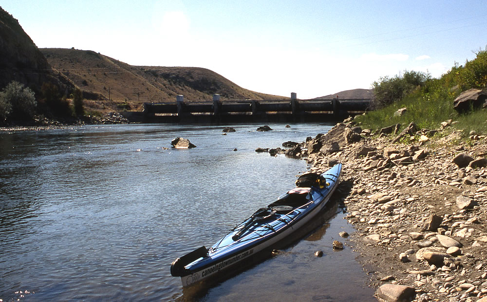
The mountains that spread around me were spectacular but they were in a desperate need of a good rain. Just before moving under a high derelict bridge, an impressive side canyon and creek joined the Missouri from the right. To my dismay the current started to ease here as I entered Toston Lake as another train passed by. Disappointingly my paddling speed dropped to under 5 miles an hour as I crossed the small lake. I stopped for a pee on some pebbly rocks and surprised several ducks and pelicans which were standing on boulders nearby. It was only a small lake so I soon arrived at my first dam, pulled out on the left at a boat ramp and started unloading.
When Lewis and Clark explored the river there were no dams. Sadly over the years the river has been subjected to many changes with several dams being built which has in turn formed small and huge lakes, some over 220 miles (350kms) long. These dams have created about 17 portages varying from 300 yards to 4 miles in length. It is only between the lakes where the river runs free that the river is similar to what it used to be and it’s not until the last 750 miles (1200kms) that it has no barriers at all. At this point the river has been straightened, deepened and channelised to allow barges to carry goods to towns along its path.
With my gear in several bags and backpacks I walked and wheeled my kayak by trolley along the dusty track passing several workmen, working nearby. After I passed the dam wall I searched for a suitable spot to put in and found a shallow spot down a rocky bank. As I returned for another load it was stifling hot and although the portage was only a few hundred yards it was still extremely hard work especially because I wasn’t in top shape.
Water was being released from the small dam, so when I got away from the shallows and exposed rocks there was a good current running. Once under the bridges at Toston the hills started to spread apart and the countryside opened creating a good place for antelope, deer and eagles to roam and which were plentiful. Despite the fairly quick current, it still seemed hard to gain the miles and as my drinking water was hot, it did little to quench my thirst. I set my sights on reaching the York Islands bush camp, which meant I would have paddled 36 miles (60kms) for the day, which I didn’t think was too bad for the first day.
Downstream of Toston Dam
I passed two men who were in an anchored boat and fishing. A little further I caught up with three other men in a dory boat who were drifting with the current and fishing. (A dory is a small, shallow-draft boat, about 16 to 23.0 feet long. It is a lightweight and versatile boat with high sides, a flat bottom and sharp bows.) What a pleasant way to fish. They put their boat in upstream and just sit there and fish or look at the scenery and let the current take them downstream with no effort at all. I sped by them and arrived at York Island boat ramp about 7.00pm. Two couples were loading their canoes onto their cars when I arrived and by the time I was unpacked and claimed a camp site, the young fishermen arrived. They had caught 15 carp but they said they weren’t good eating. We chatted as I watched them load their boat on the trailer and they couldn’t believe that I was going all the way to the Mississippi. I asked them about hoons and yobos in the area, but they didn’t know what I meant. They are people who get drunk, start a fight or make a nuisance of themselves, I said. They did know what a middy of beer was though, so they must have been drinkers! I was waiting for them to offer me a cool drink, it had been a thirsty day, but they forgot to be hospitable.
When they were gone I erected my tent on a grassed spot overlooking the river. It was a nice camp for my first night. I had a table, a bench, a toilet and a beautiful view of the river and the fish were jumping. I soon had some water boiling for a hot chocolate drink. I needed something to help my weary body get some energy back. My backside was a little sore, from the seat of my new kayak, but because I had my trusty thermarest self inflating kayak seat with me, I could use it the following day to make it more comfortable.
 York Islands Bush Camp
It had been a very hot day and it took until 10.00pm before the temperature cooled down. As soon as I had eaten I felt much more refreshed, but with a slightly weary body, I later laid my head to rest at a place that Lewis and Clark had camped, 201 years earlier.
I decided on starting my paddle on the Missouri a little later in the season than most paddlers would have started because I attended the Summer Outdoor Show, in Salt Lake City, which was one of, if not the biggest outdoor retailers show in the world. Here all the latest gear was on show. Canoes, kayaks, tents, backpacks, boots, clothing and everything else that is used in the outdoors were there to check out. I was there for 3 days and I still didn’t see everything. Whilst in Utah I stayed with Ed and Sue Jager who lived in Ogden about 60 miles north of Salt Lake City.
Whilst there Ed helped me with my shopping, took me sightseeing and gave me the run of their kitchen to pack all my food into individual day packs, so I knew exactly how many days food I was carrying. I also put another hatch in the kayak behind my seat so I could use it to store all the important items I wanted to get to quickly along the way, like my first aid kit, my film, my electronics etc.
Living with Ed and Sue also helped me to get to know them better as I had only met them for a brief time when I paddled the Yukon River.
Tuesday 15th August – Day 2
A car came into the picnic area to clean the toilets fairly early. I stayed in bed until they had gone. It was a nice morning, the sun shone briefly, but it was soon a little overcast and hazy. It took me 2 ½ hours from getting up to packing up which seemed a little longer than I expected to take.
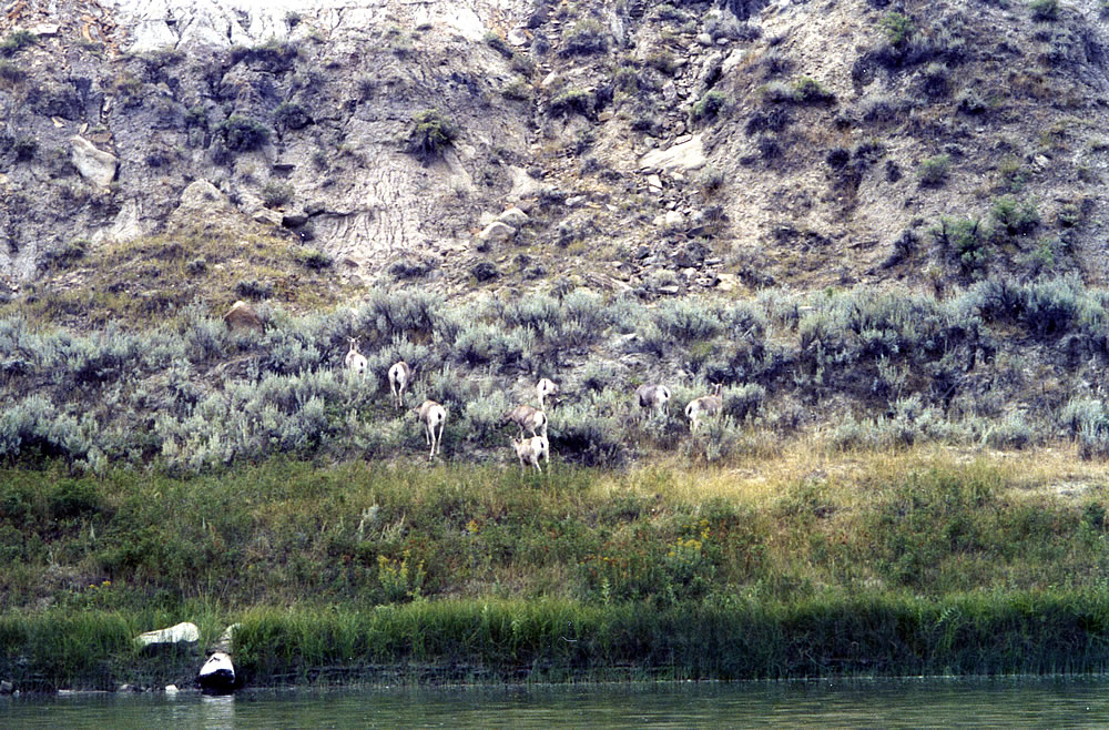
A little downstream the river divided and concrete slabs had been dumped along the shoreline. It looked messy. A sluice gate nearby was diverting water from the river and into the fields. A little downstream of where the channels came back together, 18 pelicans were stood in the shallow water. One hundred yards further four deer grazed at the water’s edge. They watched me for a few moments and then decided to high tail it, fleeing one after the other.
Soon houses of Townsend started to appear, and after I paddled under the town bridge, the river shallowed several times. I spotted a black & white woodpecker type bird, but I didn’t have a bird book so I couldn’t put a name to it. The river broke into a few channels and I had to be careful not to take the wrong one or else I could get stranded on a sandbar. On my map the blue of a deep lake was straight after the bridge but in reality the lake was so low I had to paddle miles before seeing it, in fact it felt forever. Water birds were flitting around just before reaching the lake and there were hundreds of pelicans standing in the shallows. They greeted me, but when I got too close they flew off. I eventually reached the deep water lake at 11.00am. It was calm and flocks of water birds were sat on the lake’s surface in several places and the sight of them looked pretty impressive. Also at this point the water had lots of thin pieces of weed in it.
Two fishing boats were anchored out on the lake and a train was labouring up a hill over on my left side near the mountains. It took forever for it to climb the hill and I must have had it in my sight for nearly an hour. It was heading for the city of Helena. I could also see a highway following it and the odd house or two. I finally reached a shaly beach near a point on the edge of the lake where I could stop. It was still hot and my energy was waning and when I carried on, the sun and my tiredness caused me to nod off. When I reached the White Earth Recreation Site at 2.15pm the US flag was flying high and there were a few campers milling around. People in the US are really proud of their flag. I stopped for a few minutes and talked to the roving rangers and a few other campers.
Just before the camp grounds there was a couple of green fields, I mean green. They looked strange sandwiched between nothing but dry dirt or grass. After seeing so much extremely dry countryside it was difficult to imagine that there could be crops growing there, but with the lake, there was a lot of water to irrigate with.
As I left the White Earth camp ground, there were two jet skiers racing across the water and a few boats, some of which the occupants were trying to water ski. A few weren’t very successful but it gave me something to look at and keep myself from falling to sleep. I could now see the end of the lake, but getting there I felt was going to be one hell of a hard slog as I was tiring. I eventually reached a point where houses were situated on the left shores and there were some grand houses amongst them. I felt better now as I could see the end of the lake ahead.
Occasionally the wind would blow hard then die down. It was still hazy as I moved through a channel between an island and mainland but there was some truly beautiful rock on shore and the smell of pine trees was like being in heaven. I could see the dam wall and then the marina appeared around a corner on my left, so I started to paddle over to it. There were some beautiful beaches between the stunning granite rocks, a lovely place to camp, but they were a bit close to people and I could imagine a ranger coming by and moving me on. Two people were having a picnic on one of the beaches between the rock, it looked so romantic.
 Near Canyon Ferry Dam
I pulled up at the marina but no one was there, they were closed on Monday and Tuesday. I left and paddled partially across the lake and then spotted a man on a beach 600 metres away. I raced towards him, as I needed directions to how I would get around the dam wall as I was told that the Canyon Ferry Dam wasn’t easily portaged. Looking at the canyon walls I could understand why it may be so difficult. The man greeted me eagerly and said he would give me a lift around the dam wall there and then, but he was on his way to a meeting. Instead he said he would pick me up at 7.30am the next morning at the Sheriff Campground, which he indicated was over on the other side of the lake.
I left him and paddled over to a boat ramp and asked a lady and an old man if they knew where the Sheriff Campground was. They said they had lived there for ten years and they had never heard of it. I moved on and then saw a camp ground around a point so I paddled across to it and asked some people in a caravan. It’s around the corner, but it was closed because they were sealing the roads. Then the two men offered to take me there in their boat, so we jumped in and we sped around the corner. It looked a much nicer camp than where the people were, so I decided that I would paddle around to it and camp there anyway, closed or not.
When I arrived I erected my tent overlooking the water and made dinner. Several deer were grazing around the deserted camp ground. As I wrote my diary lying down in the tent my leg cramped. I stretched it and gritted my teeth as the pain was more than I wanted to endure, but I had no choice, it kept cramping. The day had been hot, it had been hard work and I may not have drunk enough water, so it looked as if I had over done it. It eased and I was really grateful. I had only paddled about 36 miles again, but today there was a lot on non moving water and it was only my second day, so I expected to get better.
Wednesday 16th August Day 3
A sweeper machine and front end loader started working at 4.00am and woke me. I couldn’t believe my luck. My dream camp had been invaded by machines and noise. I was up by 6.00am and had all my gear packed and walked over to the road entrance 200 yards away to wait for Rob. I suppose I should have portaged, but I didn’t have a clue how far it was and where to go. I now wanted to walk as I felt guilty taking a lift and I knew I would curse myself when I got home, but I had arranged it so I decided to go with the flow. As I waited 4 deer crossed the road and another family of dear were eating by the side of the road a few metres away.
I wasn’t feeling too good as I was short of sleep. It was trying to rain when Rob turned up at 7.30am as he promised. We quickly loaded every thing into his car and tied the kayak on the roof. Driving to the portage didn’t feel that far, it was probably 2 – 3 miles mostly down hill so I really should have walked. I now felt really bad, but at least I met Rob Cole who dropped me off at the park, next to the river just below the dam. Rob worked at the Canyon Ferry Dam, but he originally came from the city of Pierre, where he used to work with the water department there. I said my farewell and thanks to Rob and he was off to work.

Canyon Ferry Dam
I left my gear on the ground and walked to a caravan to ask a couple if the water in the park was okay to drink. The lady had a few teeth missing and the man was a diabetic who was smoking and a little overweight. They invited me in for coffee and banana cake that someone else in the park had made. I was a little bit dubious about the cleanliness of the cups as the caravan didn’t looked very clean, but the coffee was actually quite nice. I don’t like strong coffee but this was okay. She explained a few things about the river and gave me 4 muesli bars for later. The lady later came across to the kayak to take my photo.
As I packed there was a little bird hanging around, and it was a little inquisitive, flitting from the ground onto my gear and onto the kayak. The friendly little thing reminded me of an Australian wagtail. I launched into the narrow river at 9.10am, and moved by a house on the right and another which had a whole tree in their back yard that had been carved into an eagle. It was a pretty amazing sculpture but it destroyed a tree. I don’t believe I have seen that done before, not to a tree in your own garden. A kingfisher was flying between the trees and a deer was grazing on a grass patch downstream.

Sculptures
As the river started to widen there were hundreds of petite ducks scampering across the water and hardly getting airborne. The water was turned into a sea of ripples like a carrot grater. As I turned a bend, to go towards a bridge, I had great views on the surrounding hills with the Big Belt Mountains being in the far distance. I passed a boat ramp and camping ground just before York Bridge and after passing under it, the river narrowed into a gorge and the scenery was spectacular with high cliffs.

York Road Bridge

Beavers had been busy felling trees just before I reached a pleasant isolated picnic area situated in a small cove, on the east side of the river in the Helena National Forest. Within a few miles I was out of the special scenery as the river widened and the hills were formed further back. Then on the right side I moved by piles of rock tailings, which I assumed were left over from some mining or quarry venture. Further along slithery weed was thick in the water and as I paddled I would lift the thin stalks in the air with my blades. At the same time about 4 light planes and 2 helicopters flew over and across the river on the left where I could see a good camp spot and boat ramp.
I reached Houser Dam at 1.00pm. It was a hot portage, but it didn’t take me long to walk my gear to a flat spot opposite a house. It was easy out and easy in. An information board said the dam broke through on 14th April 1908 a year after being built and caused severe flooding and damage downstream, but luckily authorities were able to warn people downstream and it saved a lot of people. A second dam was built on the site in 1908 and opened in 1911 and comprises the current structure. The current Hauser Dam is 700 feet (210 m) long and 80 feet (24 m) high.

Hauser Dam
There were 2 fishermen and 2 deer just downstream of the dam. I paddled by them and suddenly the scenery became quite spectacular but only a few kilometres later the current died as the river widened and started turning into a small lake with a few houses, a marina and boat ramp over to my right.
As I headed north to north east, I approached an area called the ‘Gates of the Mountains’ which was named by Lewis and Clarke when they came from upstream. Sitting out on the water I could see mountains from 5000 to near 8000 ft surrounding me. The way ahead though took my interest as I was approaching a stunning set of cliffs and rock walls that seemed to have blocked the river’s path. I strained to see where the river went, it seemed blocked by the rock walls, although I knew from the map it must be there somewhere. I got closer to the spectacular high cliffs and finally I could see the rock walls open up and the river cutting through the cliffs.
 ‘Gates of the Mountains’
I entered the narrow gorge and found vertical cliffs running along the river’s edge honeycombed with holes and pine trees that grew in every crevice. The deep green pine trees at the top of the cliffs contrasted beautifully with the blue sky above. The cliffs at times rose vertically from the water and at other places there were rock falls and when the cliffs edged away from the river pockets of vegetation and pine trees grew. I passed a few good camp sites in the breaks in the cliffs and under the pine trees. As I drifter through the narrow impressive gorge, the blue grey cliffs were so close and imposing I could see every nook and cranny and somehow I felt part of the environment. Of course I wasn’t, but for a few minutes I could daydream and get pleasure from my stunning surrounds and imagine if it was any different when the local Indian Tribes used to live and hunt in the area. As I passed Coulter Camp, which looked a fantastic place to stay, I thought I should stay there the night, but with the sun still high in the blue, partly clouded sky I carried on.

A few boats motored by, and as I reached the Meriwether Recreation picnic area, which was on the right, on a left hand bend, a tour boat was just leaving. A rugged gully forged up the mountain range on the corner and behind the picnic area. It was truly a spectacular, special place, so much so that I didn’t want the gorge to end and leave such magnificence behind. I was hoping it was going to go on for several miles yet.
 Inside the ‘Gates of the Mountains’

Coulter Camp
July 19, 1805 from the diary of Lewis & Clark
this evening we entered much the most remarkable clifts that we have yet seen. these clifts rise from the waters edge on either side perpendicularly to the hight of 1200 feet. every object here wears a dark and gloomy aspect. the tow[er]ing and projecting rocks in many places seem ready to tumble on us. the river appears to have forced it’s way through this immence body of solid rock for the distance of 5¾ miles and where it makes it’s exit below has thrown on either side vast collumns of rock mountains high. the river appears to have woarn a passage just the width of it’s channel or 150 yds. it is deep from side to side nor is ther in the 1st 3 miles of this distance a spot except one of a few yards in extent on which a man could rest the soal of his foot.
A little further I paused at a sign saying Mann Gulch Fire – 13 Firemen Died. The Mann Gulch fire of 1949 was a wildfire, which claimed the lives of 13 firefighters including 12 smoke jumpers who were parachuted into the area to fight the fire, but were unable to control it. The smoke jumpers had jumped out of a plane and landed by around 4.10pm. By the time the scattered cargo had been gathered it was about 5.00pm. At about 5.45pm, the crew had seen the fire coming up towards them on the north slope and had turned to run. By 6.00pm the fire had swept over them. The time of the fire was judged by wristwatches stopped by the heat. 450 men fought the fire for five days before it was controlled, which had spread to 18 km² (4500 acres), under control.
I paddled on and it seemed that I had now left the best scenery, although a jagged mountain appeared over on the left where deer were grazing in the dry grass beneath it. It was still very windy and suddenly a thunderstorm erupted behind me, the thunder echoing across the valley. The evening soon darkened and flashes from lightening strikes criss-crossed the sky as the storm drew closer. Fearing being struck I paddled on with vigour hunting for a suitable place to camp. I rounded a left hand bend just opposite a narrow neck of rock where the river did a U turn near Oxbow Bend.
Within minutes I found a fitting campsite overlooking the river and a narrow craggy range. I felt safe and secure, but quite drained. The sun, the wind and the strenuous days paddle had tired me out, although I had only paddled 35 miles (57kms). It was a nice little spot and I only had to pull the boat up a few metres to get it from the water. With the tent erected I had a very cold water wash from head to tail and then put cream on my feet to keep them healthy. When I paddled the Yukon River my feet started to blister after 45 days of walking in the mud, so I was trying to prevent that from happening on this trip.
Thursday 17th August – Day 4
I slept well, although throughout the night there was water lapping up the shores and popping in the hollow rock. It was a strange noise. It also rained, but luckily it was only falling lightly when I ate breakfast and moved off.
I rounded the first corner but the high cliffs couldn’t shelter me from the hail storm. It got cold and the hail was stinging my skin so I stopped to put on a thermal and my kayaking jacket. The hail also made thousands of indentations in the water and created some fascinating patterns. There were a few houses along the shores on the bend with a semi circular mountain behind them. It was hard to imagine how they got cars into the area as it looked a bit rugged. A mile or two after the river made a big U turn the hills flattened and the river started to wider. There were two van parks on the right hand side and as the river started turning into a lake, lots of houses lined the right shoreline. Many of these houses were empty and I imagine that most were holiday houses. Many of the people who were at home had the US flag flying, a bit of a giveaway for any thieves. I noticed that one house had gnomes in the garden looking like yogy bear, seals, birds, and eagles, but I certainly didn’t like them.
It was still windy when I reached Holter Dam wall. It was an easy take out, four steps and level ground. I portaged down a path, and through a gate passing an eagle’s nest aloft a tall pole before reaching a boat ramp. I talked to some fisherman before retuning for another load. It started raining heavy. The portage was about 300 to 400 metres, easy out, easy in but a bit of a strain in between. When I returned to the ramp I started talking to a man and his dad who were from Florida. They said, that they were only allowed to take one fish of each species. They moved on as another group in rubber rafts were taking off.
 Fishermen a plenty on this stretch of water
As I launched, I was quickly pushed away by the swift current and straight under a flying fox and a cage that was suspended above the river with a man in it. As I moved underneath him I said, “What are you doing.” He said, checking the speed of the water. As I floated downstream I felt awful because I said, “What are you doing,” without saying, excuse me. Funny what plays on your mind!
The next 500 metres of river was busy with fishermen in dory boats. There was a good river flow and fishermen a plenty from all around the country in a multitude of different water craft who were all vying for the same piece of cold water and the same fish. It was an easy trip to the bridge and I loved it.
Downstream from Holter Dam the Missouri river provides great fly fishing from late spring through the fall. This portion of the Missouri was said to hold over 5,000 trout per mile with the population comprised of approximately 75% rainbows and 25% browns. That seemed a lot to me but if it was true, no wonder there were so many fisherman on the river. Most of the fish caught on the Missouri average 16″ to 18″ long, but there are still many over 18″ to 20″ long. I only usually fished when I needed a feed, but I was being tempted when I saw people hauling them in.
I skirted by 4 pontoon type kayaks with fishermen fishing near the side of the river after Wolf Creek Bridge. They were boats that I haven’t seen in Australia, although they will filter through to Australia one day, I’m sure. Downstream further, the rolling hills continued to be a source of inspiration and pelicans were parked on one side of the river, deer on the other and eagles soared overhead. The scenery even got better as the hills started to close in. This was my type of paddling. A single railway line ran beside the river keeping to the edge and skirting the grey rugged steep hills and cliffs sparely forested with pine trees. I drifted under a bridge, passed a rail tunnel going through the solid hill, another bridge and then after the houses at Dearborn I stopped on an island opposite a house to change the film in my camera.

The water accelerated as the river parted and the grade steepened. I didn’t know what was around the next corner but the swift current didn’t produce any big rapids. The day was heavily clouded and rain threatened, but only light rain fell. I moved through more spectacular scenery and rocky black hills. I was mesmerised by the astounding landscape and longing for it to continue. Fly fisherman dotted along the river and later that afternoon I came to a bridge with a section of small rapids downstream of it. A dingy floated down the river with fisherman casting their lines. Life here can’t be bad, I thought. I paddled left of them following a fast jet of water through some big waves dodging several rock bars and out into the still water. Suddenly the rapids, the beautiful hills and the spectacular scenery started to fade and the countryside flattened and quickly grew quite uninteresting. The mountains were now behind me as I headed towards the mid North West Great Plains.
 Hills around Dearborn

The current slowed as the river meandered its way across the plains towards the town of Great Falls where a series of dams and falls intersected the river. Although the spectacular scenery was lost on this part, eagles, deer, beavers and a multitude of water birds kept my interest. Tall poles along the river had been erected for eagles to build their nests on top of them. With nightfall approaching I started checking for camping spots, it was quite swampy, but eventually at 8.00pm I found a flat swampy spot that was drying out with a lot of goose poo on it. As long as there wasn’t an influx of water coming down the river in the night I would be okay. The clouds had gone, the sun was shining and I was feeling good about the day. A pod of geese flew over sounding like Australian brolgas. I unpacked watching a beautiful sunset.
 Upstream of Cascade
Friday 18th August. Day 5
I had a dream in the night. I was a cop in the Bill and I went out on a raid and managed to get cornered by some drug addicts who were about to kill me. Somehow I managed to escape, with them following. Luckily I woke up just before they caught me.
There was a heavy dew, but the sky was clear. I watched a coyote on the other side of the river walking along the river bank, stopping, looking, walking and stopping again. Deer were also roaming the rivers edge and when I got going I saw more. The river continued to meander through the plains and small hills. The current slowed and I was paddling 5 to 5.5 miles (8.5kms) an hour and I felt a little cheated after the good flow I had on previous days.
A pack of 8 deer played and grazed, eagles and ducks flitted around and I heard a bird call, that you hear in a western movie which gave me goose bumps. I passed the odd house, a lady walking 3 dogs, an eagle on a pole, car bodies dumped off the edge and into the river, and a deer trying to climb a steep sand bank which fell back down. Although the landscape was boring the animal life kept my interest, but I must admit I was longing to have a faster current again.
 Eagles nest perched on a pole
At Ulm Bridge I didn’t stop because two dodgy looking fishermen were there. Flocks of geese were now on most of the islands that I passed, beavers became a common sight and eagles were still present. It was good to hear the twitter of baby eagles in the nests on the high poles. I stopped on a bend and across the river there was a line of old train carriages, which were rusting away on an old train track. Houses started to appear, some were grand mansions, but most looked deserted. In one of them though, I actually saw a man cutting the lawn and a women sun bathing. I waved hoping they would invite me in for afternoon tea. They didn’t, but at least they waved back.
 Abandoned rail carriages
At an irrigation pump station I stopped and asked a young guy where I could camp. He said anywhere for the next few miles as it is all his land. The hills were getting closer, power boats started passing and I talked to a couple who were parked up in the shallows, but they had no suggestions where I could camp. It was 5.15pm, it was hot and it was quite early to stop but I didn’t want to arrive in the city of Great Falls at night fall, so I started looking. I found a beach next to a house and across from an island that was teeming with geese. On one side of the block I had a nice big rock to perch on and watch the beavers swim around and the sun to set. I boiled some water and had a hot strip wash using my clean hanky as a flannel. It was perfect.
Saturday 19th August. Day 6
It was an easy paddle to the town of Great Falls where I checked out the first boat ramp and found three couples drunk and arguing. I moved on and stopped at a newer ramp with a big car park and a telephone that didn’t work. I dragged the kayak high onto the grass and changed into my going out clothes. There was a large notice board with information about the portage and the dams ahead so I took down the contact phone number. I walked along the road trying to find a shop and a telephone but there were no shops nearby, but I was told there was a supermarket and shopping centre on the other side of the river about 2 miles away. I returned to the kayak packed everything inside, closed it up the best I could, took out and carried most of my valuable gear and went walking.
It was hot and I didn’t really know if my kayak was going to be there when I returned as it was in a very public place, but I needed some shopping and I had to get advice about the dams in front of me. The falls downstream had been a serious barrier for Lewis and Clark as they made their way upstream. They had taken several days to portage them and it had been very hard work. Today though, those falls below the town are part of five hydroelectric dams which have taken over the falls and the gorges and created a nightmare for passing canoeists and probably more of a hazard than when Lewis and Clark were here.
I arrived at the shopping centre and rang the number that was on the portage sign. I got a guy called Jim Meade who was from the Medicine River Canoe Club. I asked Jim for advice about the way ahead and he highly advised me not to paddle the next section as the five dams and rapids were too dangerous to take on. He said he would give me a lift around the dams, so if I wanted a lift he would pick me up. I really wanted to paddle and portage it, but not knowing how bad the next section really was, I decided it best to take Jim’s advice.
I had two hours to shop before Jim said he would pick me up at the shopping centre. I needed a new watch because mine had ceased to work, a few pieces of gear and more film, so I rushed around the outdoor store and then to a camera shop.
Jim picked me up at the shopping centre and drove me back to the kayak and loaded it onto his truck. He had brought water so I could top up my supplies and then drove me to McDonald’s for a hamburger. He must have known I wanted a feed before getting back on the river. We were eating our burgers when a group of Hutteran Brotherhood, commonly referred to as Hutterites came into the store and started chatting to Jim. They were dressed in Quaker clothes and all the women looked very, very similar. Even the young ones looked similar to the older women. They were a religious society similar to the Amish or Mennonites and speak a form of German. They were extremely friendly to Jim, but I was surprised to see them in a McDonald’s fast food outlet as they usually grow their own vegetables and bake the best bread in town.
When we left Jim detoured to the first dam below the town so I could have a look at it and the rapids below it. I really wanted to get back into the water on the right side of the river, just a few kilometres downstream, at Morony Dam, the last dam on the river, but Jim said, the road wasn’t good to get into that particular spot. Being at the mercy of his kind offer to drive me, I decided I had to go with his suggestion, although in hind-site I would have risked portaging all the dams.
 Black Eagle Falls
Lewis & Clark
Leaving the comforts of Fort Mandan on April 7, 1805, Team Corps arrives at the great falls of the Missouri on June 13, 1805.
The Captains anticipate the portage time around the single falls of the Missouri at approximately 2-days, in reality they found a succession of rapids, cascades, and five falls covering over twenty miles plus an incline of 500 feet!
The Corps would have to hike 18 miles to get around the five waterfalls. Crooked Falls, Colter Falls, Handsome Falls (today’s Rainbow Falls), and Black Eagle Falls. Besides the falls, the river here was a sunken, roiling trench hurtling between 200-foot cliffs. They left their heaviest boat and equipment hidden near the base of the falls. The other canoes and supplies were carried, dragged, and pushed. The Corps created makeshift wagons. When the wind was strong, they attached the boat sails to help move the equipment.
The ground was rocky, uneven, and hard. Prickly pear cactuses were everywhere. The Corps wore through their moccasins every two days. The intense heat of the summer sun was interrupted by violent storms, with thunder, rain, and hailstones the size of eggs. Swarms of gnats and mosquitoes pestered them. Rattlesnakes and grizzly bears were a constant threat.
Finally, after nearly a month of hard labor, the portage was complete. The Corps and their equipment were on the other side of the falls. They built new boats to replace the one left behind. They started back on their journey on the Missouri River on July 15, 1805. They were more than a month behind schedule, but happy to be past the Great Falls. Their next challenge was to find horses and make it over the Rocky Mountains!
Driving along the highway towards my put in point I was surprised to see how dry and flat the countryside was. I was traversing the mid-west plains and I suppose before settlers came this area would have been miles of grassland. Lewis and Clarke mentioned that they encountered huge herds of buffalo on the plains all along this section of the river and I as we drove I could imagine the buffalo roaming. Today though there were no grasslands, only the remnants of wheat fields. We soon turned off the highway and down a gravel road heading towards Carter’s Ferry and the start of the famous wilderness areas of the National Wild and Scenic River Area and the Upper Missouri Breaks National Monument.
At the end of the dusty track, that led down into a dry parched gorge, stood Carter’s Ferry and the ferryman’s house. At the point of the ferry crossing the escarpment ridge was lower than upstream or downstream. It was extremely hot down in the hollow but Jim had had bought an esky of drinks to refresh my thirst. We stood next to his truck, which number plate was 02 CANOE and sampled them. I was ready to pack, so I said my thanks to Jim for taking time out on a Saturday to drive me around the five major obstacles of my trip, but he was very happy to be of assistance. Apparently Jim is employed to drive canoeists around the dams by the Hydroelectric Company.
 Jim Meade
Jim left and I finished packing. A car came down to the small ferry that was fastened to a cable and was winched across the river. After it had crossed, the valley was so quiet again. Twenty minutes later I dragged my kayak off the rock bank and slipped into the cockpit and paddled away from the ferry with the fast current. The next section of the river is one of America’s great paddling wilderness areas and I was heading towards it.
 Carter Ferry crossing
I put my disappointment of having to portage behind me and paddled beneath rugged steep cliffs in the clean water, and the silence was frightening. I was in a place where it seemed that nothing could grow in the dry hot valley and to go ashore amongst the crumbling cliffs would be risky. At a bend there was a flat section on the right hand side, a farm and several buildings. The valley at this point had crumbling cliffs on one side of the river and an oasis of irrigated fields on the other. It was quite a contrast. I continued on I found another farm with a big irrigation field just before arriving at Fort Benson. With a little water it’s just amazing how crops can grow in such an arid place.

Just before the last bend of arriving at Fort Benton the cliffs were ridged like sharks teeth, but beyond them as the river turned for the last time the left side was low and green and a small channel had split from the main river and ran through the low vegetated area close to shore. The campsite I was headed to was at the beginning of the town, so I had to be careful not to miss it as it was hidden behind the green vegetated plain. I pulled into a channel and eventually saw the camp ground and within minutes I had my gear next to a table.
The camp ground had a shower and laundry, so I was able to have a shower and wash my clothes for the first time since starting my journey. The town centre was about a mile away so I took a walk, looked around and had a meal at a café across from the river. I tried finding a public phone, but the two I found had been vandalised and a long time out of order. I tried the historic hotel and they allowed me to use theirs, so I rang Jenny. A supermarket was still open, so I bought a few groceries and returned to the camp ground and that evening I had a seat and a table to sit at. The night was crisp, I sat and had time to reflect and appreciate my journey so far. It would be three weeks before I would be able to stop at another town and shop again.

Grand Union Hotel, Fort Benton
Sunday 20th August. Day 7
I knew I should have got up early, but frankly I couldn’t give a dam about the time. I just laid there for a while and rested. I was also slow to get going. I launched at a different spot further downstream, it was a longer walk but it was easier to load the kayak there. I finally left a 9.15am, paddled a mile or so and stopped at the town ramp to have a look at the Lewis and Clarke memorial statue. As I returned to my kayak two canoes were getting ready to leave. I finally left Fort Benton at 9.57am.

Downstream osprey, pelicans, geese, ducks, turtles, beavers and deer continued to cross my path. There was a farm around the bend with tall blue silo. A little further a deer was getting shade as it laid under an eroded vertical bank below tree root. It looked sad. Other deer were on an island, cranes were around the bend and apart from osprey calling, the day was silent. Ahead several ducks started to scurry across the water in front of me. Their wings flapped and hit the water and made a sound like rapids. When they were gone it was silent again.

The countryside was dry, steep with cliffs on one side and lower flat areas on the other. The heat was intense in my valley of hot rocks, crumbling cliffs and dry scrub. I was alone in a craggy canyon, when, from out of the blue I saw a dog, a cowboy and cowgirl on timid horses herding a small bunch of cattle. They stopped to allow their horses to drink at the rivers edge and as I drifted by them we chatted until I was no longer in earshot.
I stopped at the Wood Bottom camp for a stretch. I passed under a bridge and soon after the Marias River came in from the left which was an important landmark of the Lewis & Clarke expedition. As Lewis and Clarke came from upstream they didn’t know which river was the Missouri River and which one was a tributary.
Lewis and Clark split up in order to investigate both branches, Lewis took the northern fork (Marias) as far as 80 miles and Clark took the southern fork as far as 55 miles.
Clark Diary – June 5th Wednesday 1805 checking the south fork
Some little rain & snow last night the mountains to our S.E. covered with snow this morning – air very cold and raining a little, – we saw 8 buffalo opposite, the made 2 attempts to cross, the water being so swift they could not, about the time we were setting out three white bear approached our camp we killed the three & eate part of one & set out & proceeded on N. 20 degrees W 11 miles …..
Lewis Diary – Thursday June 6th 1805 checking the Northern Fork
I now became well convinced that this branch of the Missouri had it’s direction too much to the north for our route to the Pacific, and therefore determined to return the next day after taking an observation of the O’s Meridian Altitude in order to fix the latitude of the place…………….
Although most of the party, except for Lewis and Clark thought taking the south fork was the wrong way to go, they happily followed their leaders up what they thought was the wrong fork. They took the south branch which had clearer and swifter water.
What amazes me about Lewis and Clark is that they used to go off walking into the mountains or onto the plains by themselves all the time and somehow they always found the expedition party again. Not only did they have grizzly bears, rattlesnakes, buffalo and just getting lost or injured to contend with, but they never knew how friendly the Native Indians were going to be. For most of the time they only wore moccasins on their feet, which they had to make themselves out of animal hide.
The crew also had such a difficult task, as they had to be in the water most of the day hauling the boats up stream against the current by cords, over sharp and slippery rocks and snags. The also had to withstand the torment of the mosquitoes.
As I passed the Marias River mouth I could see a big square tall building, which was probably a building near the small village of Loma as it was close by. Apart from a turtle sat on a rock there was nothing exceptional about the joining of the two rivers. Further along there was a ranch on right, a horse ranch on the left, but there was no one around at either ranches and apart from the cicadas it was quiet.
The current was now slower, the hills were now lower and breakaway gullies and pockets of irrigated fields were occasionally nestled between the river bends. I passed Vigelle Ferry at 4.47pm and arrived at Coalbanks Recreation Area at 5.25pm. I landed and walked to the camp manager’s recreation vehicle. The couple said they were voluntary camp wardens and they stay there the summer and go to Baja (Mexico) for the winter. After a short chat I returned to my kayak and met and talked to a few other campers before moving off.
A little further I noticed that four huge trees had been chewed and felled by beavers. It was such a waste of good trees and there weren’t many around. It is amazing the amount of destruction a beaver can make. Cottonwood trees, which give good shade were once numerous along this section but over the years, due to cattle grazing, young Cottonwood trees haven’t been able to survive. With the beavers and the cattle, there will soon be no shade along the river banks at all.
I could finally see white cliffs in the far distance. These were part of the Upper Missouri Breaks National Monument and by all accounts one of the most beautiful parts of the Missouri River and I was determined to camp beside them. On shore a few miles further I spotted a voyageur canoe pulled up on the bank and a family camped further back in the scrub. They were sitting on chairs relaxing in their big tent and having some family time. I waved, and not wanting to disturb them, I passed by.

Upper Missouri Breaks National Monument
By days end I made it to the Eagle Creek camp area where the striking white cliffs were scattered along the rivers edge and being illuminated by the setting sun. It was a stunning sight, but with the water receding every day the banks were wet and soggy making it impossible to get out of the kayak without getting seriously muddied feet. As soon as I had my tent erected I could relax and appreciate the striking scene. To its detriment though, cattle were still allowed to roam the area nearby and it was off putting having to avoid the cow pads and the erosion and mud that the cattle have created along the river banks. I was a little confused why a National Monument would still allow cattle to roam. It was quiet when I retired, but the coyotes were active and the echo of the howling bounced off the cliffs throughout the night.
 Upper Missouri Breaks National Monument

A full management plan is still under development due to various private inholdings and lease agreements between private citizens and the federal government. While conservationists would like to see some of the Breaks Monument lands become designated as Wilderness, local ranchers and farmers, under long standing lease agreements with the federal government who graze upwards of 10,000 head of cattle annually within the new monument, are concerned that the monument status may adversely affect their livelihood and the economies of local towns
The need for grazing reform is great. Reports that past grazing management has resulted in almost complete elimination of important woody shrub species such as red-osier dogwood, chokecherry, serviceberry, currant, and gooseberry – all of which are highly important as food sources for mammals and birds. Another grazing related problem is the impending demise of riverside cottonwood forests. Presently almost all of the cottonwood trees along the river germinated from seed in the 1880s, before grazing was occurring on the river. As cattle grazing became an entrenched use on the river, cattle have systematically eliminated virtually all young cottonwoods, leaving no replacement trees to take the place of the old and dying mature trees.
The Breaks is home to at least 60 mammal species and hundreds of bird species. Willows and shrubs are found along the Missouri River banks while sagebrush and short grass prairie are dominant elsewhere.
Monday 21st August. Day 8
There were clear skies, but it was windy and it was directly in my face. I had great views, in fact apart from the mud and a few cow pads, it had been a good campsite and very entertaining with the howling in the night. Along the river the white cliffs were scattered and with the sun shining directly towards me it was better to look behind when I passed the cliffs, to get the best clear views of them. The scene was striking, but I had imagined from what I read, that there was going to be a longer continuous line of white cliffs, so although I was loving the stunning scenery, I was a little disappointed that there weren’t more cliffs.
A pinnacle shape rock appeared, I just had to drift and ponder as it was quite a spectacle and a little beyond it there were some magical formations and hills on the right. Soon after, when I turned a left hand bend I could see the famous ‘Hole in the Wall’ cliff at the end of the range. It was probably a feature of no consequence in the famous Arches National Park, but out here it was a beautiful and a striking piece of natural architecture that brought joy to every passing canoeist. There was a campsite with shelters on the right, but it was deserted. I paddled on and came across 3 canoes and 3 kayaks on shore, but there were no people. I took a picture of the boats and the range, as I might not see any other canoeists on route. It was one of those scenes where you would expect to see a village of tepees and Native Americans riding horses bareback across the arid land. Although there was limited cliff on the left side of the river at that point, there were some impressive sandstone formations, ridges and crevices that were quite unique.
 Upper Missouri Breaks National Monument
 Upper Missouri Breaks National Monument


‘Hole in the Wall’
Just as I landed a man’s head popped up from behind a bush. He was reading, apparently while his friends were taking a walk along a dry craggy trail to the ‘Hole in the Rock.’ By the time I got out and fiddled with my camera the others were walking back. The group were all Canadians and they were led by a guide who hailed from Eureka, in Montana. I had a short chat and within minutes they jumped into their boats and left me messing with my cameras.

Once back in my kayak I soon caught up to them and one after the other I had a short chat to them all. The wind was annoying, but the current was running fast. I told one guy that I intended to paddle the Mackenzie River in Canada in a couple of years. He said, don’t do that, it was too boring. Paddle the Churchill River instead as the Churchill is a much prettier river. When I finally passed them all, I said my final goodbye and waved, picked up the pace, and thought that I would leave them well behind, but for a group of novices I was surprised how fast they were going. They were the first canoeists that I had seen on the river, but apparently in the season there are hundreds of canoeists that paddle along this wilderness stretch.
As I came up to a right hand bend I saw two guys leaving the left hand shore. I was told by the paddlers I just met, that there was a father and son team up ahead. This must have been them. They were paddling a canoe and dragging another craft behind them. I can’t imagine why you would do that, it looked very awkward. Why didn’t they just paddle a bigger canoe!
The cliffs were now scattered and the views were less spectacular although there were still some unique sections. The wind hadn’t abated and was impeding my progress, but the swift current helped me along. I was soon passing an old house with a load of irrigation pipes and other bits and bobs, just left there to rot. There was also a swag of old machinery lying around that hadn’t been used for years.

On the other side of the river there were some mushroom rocks which had been eroded by wind and rain. They were quite unusual and very different from all the other formations. Around the next bend I came across a basic camp ground which had three guys camped there. I called in and I had a chat. One offered me a cool drink, but I didn’t take up his offer as I would be arriving at a store in an hour or two. One guy was paddling a canoe, another guy a kayak and the talkative one, was rowing a row boat. The camp was fenced off so cattle couldn’t invade it, a good idea, but the cattle were still nearby and the ground was littered with cow dun and the air was full of flies. I used the toilet whilst I was there, said my good byes and took off heading towards a fairly remote spot called ‘Judith Landing.’

Most canoeists finish their tour at Judith Landing and it is the one of the very few places canoeists can get out and where the white cliffs stretched no further. The hills were bare but now they started to have pine trees scattered near and on the summit. A turkey was drinking by the river’s edge and further along the hills and the area started to flatten. I drifted by Judith River and under the road bridge and pulled up to the boat ramp a little further downstream at Judith Landing.

I walked over and talked to the campsite host and asked him the difference between a deer and an antelope. He then went searching for a book and I was afraid that I was going to get one of those long answers and I was going to be kept there for a long time. I was really thirsty for a cool drink, so I was hoping that he wasn’t going to go too in-depth. Eventually I managed to drag myself away to visit the timber built store to buy a Gaterade drink, an ice cream, a long sleeve T shirt and a beer. The T shirt was to stop my arms from burning whilst paddling. I sat down to drink and talked to the owners, who said that business way out here wasn’t very good at the moment. I then felt as if I should buy something else.
 Judith Landing Store
Sooner or later I had to leave, although I didn’t particularly want to, but I had a long way to go and I couldn’t stop every where and I needed to make a few more miles and most importantly be camped in the wilderness alone. I left at 5.30pm.
The Upper Missouri Breaks National Monument is one of America’s most popular wilderness river systems used by hundreds of canoeists every year, yet I saw very few over the last few miles. The sheer white cliffs, eroded bluffs, towers and arches are the main attraction for every one, but being out in the wilderness gives paddlers the opportunity to camp under the stars and listen to the sounds of the wildlife. Most of the canoeists though will go no further than Judith Landing.
The Lewis and Clark Expedition passed through the breaks in 1805 and were the first to document the region through notes and drawings, and their sighting and documentation of bighorn sheep in the breaks region was the first time this species was recorded in North America by white explorers. Much of the Breaks region has remained as it was when Lewis and Clark’s party first saw it. “The confluence of the Judith and Missouri Rivers was the setting for important peace councils in 1846 and 1855. The Judith River was named by Clark, after a young woman he married shortly after returning from the expedition.
The hills were quite beautiful and calming downstream of the landing. I saw several deer and no cattle so I felt good. I still thought it odd that they allowed cattle to roam in a National Wilderness Area, so not seeing any made me happy. I was enjoying my evening paddle but then I developed a niggle in my right shoulder, so within minutes I thought it best to stop for the night and not to allow it to develop any further. I found a beautiful spot at 7.15pm opposite a rugged range of weathering gullies. I landed, but I soon had to move a few yards upstream to get away from a colony of ants. It was good to relax and have a strip wash in the last rays of sunshine.

Tuesday 22nd August. Day 9
When I awoke, there were cows mooing and they sounded as if they were on top of me, but when I stuck my head out of the tent door, the cows were on the other side of the river. Despite the cows and cow dung along the river edges ruining the wilderness feel, it was a picturesque place.
 Approaching McClelland ferry
It was cloudy and several big horn sheep were a little downstream grazing on the left. I soon neared the McClelland ferry and it was crossing the river at the time of my arrival, with one car on it. It stopped and I moved downstream of the ferry and started talking to operator Grace Sandford. We were having a good little chit chat, but the ferry at the time was still creeping along, so she quickly dashed back to the controls to stop it. I left her at 9.15am.
 McClelland ferry
The water was swift with a few small rapids and riffles, the scenery excelled, there was no wind, but it was cloudy. A white headed eagle was perched on top of a cliff nearby just watching me pass by. I hadn’t seen any cows since the ferry so I was even happier, although there was a herd of goats scampering from the river’s edge and climbing a steep slope but they seemed more natural. I passed an old derelict timber stockade and there were no cows but after a deserted timber building on the right, to my dismay the cows returned near Cow Creek. The day was hot with thousands of annoying flies.
A chopper flew over as I passed the toilet and camp site at Woodhawk South. Apart from some old sheds, deer, goats searching for food and eagles on the cliff tops there was nothing around, it was hot and silent.
I eventually came to a pocket of civilisation when I paddled under a bridge of highway 191 where fisherman, were fishing, but I didn’t stop. Apparently they catch large paddle fish around here, and I mean large. A paddle fish has a big snout. I paddled on to the boat ramp at James Kipp Recreation Area and where I hoped to top up my water containers. There was a toilet and a tap about 60 yards from the boat ramp, so I filled my water containers and washed my hair. It felt so good to be clean and have my hair feeling fresh again.
A car pulled up in the car park as I was walking back to my boat. A women and her husband got out. We got talking and the women told me that she had travelled with an Australian girl in her earlier years and she often wondered where she was now. They had a great time together and they both got very drunk in Germany. She was friendly and gave me a diet coke, but he wasn’t very sociable. As we talked he took his dog for a walk and let it go to the toilet on the car park and didn’t attempt to pick or clean it up. They were on their way to her husband’s parent’s farm.
I left the ramp at 6.47pm looking for a campsite further down stream. I caught several deer drinking at the water’s edge in many places along the way and when I saw a huge stag with antlers standing well upright on the left of the river, next to a perfect beach, I felt it time to camp. I stopped paddling and let the current take me closer, but when it felt my presence it reared its head and impressive antlers, briefly looked my way and trotted off leaving me to make camp at the very spot. After I landed a deer on the other side of the river watched me erect my tent and a beaver started swimming up and down slapping its tail. I was in bed at 10.40am.
I was now out of the Upper Missouri Breaks National Monument and the National Wild and Scenic River area and in the Charles M Russell National Wildlife Refuge and where the river carved its way through ranges, but a little less impressive than what was behind me. By my maps the landscape would flatten as the river headed towards a series of large man made lakes that would later test my endurance, skill and tenacity.
Wednesday 23rd August. Day 10
It was calm & cloudy and when I paddled off and there were deer all over the place along the river bank, many leaving the river banks by narrow paths running through the thick tall undergrowth. There were 8 here, 6 there, 2 baby deer there, four happy deer on an island and 6 tall black faced deer or elk standing their ground at the river’s edge.
A yellow pick-up truck drove up a dirt track following the river leaving a dusty trail. I was well away from any civilisation and getting deeper into the wilderness with no contact with people for days so I was a little cautious. The rough looking truck looked suspicious, a bit dodgy, I didn’t trust it. Was it going to stop on the road ahead? I was wary, but I had the advantage of being in the river, but these guys probably carried a gun and what would I do if they pointed it at me and told me to go ashore! My hope was that they would just keep going. The thought of the film Deliverance came to mind again.
A coyote was running at the base of the hills and across the dry grass. It looked free but a little thin. Occasionally it would stop, look around and then trot off again. The current was still quite speedy and I was now several miles from the pick-up truck, so I stopped to have a pee and put some fly repellent on, as the flies, even in the kayak in the middle of the river were extremely annoying. I’m usually free of flies when on the water, but not here. I moved on passing a number of beaver eaten stumps. It still amazes me to see what damage beavers do. I paddled close to a vertical bank being happily helped along by the current. Suddenly from out of no-where a big beaver jumped off the bank and into the water right next to me, narrowly missing me by inches. When I saw it out the corner of my eye I thought it was lunging leopard or something. (The author of my guide book said he saw cougar tracks near here.) I must admit, it surprised me and gave me a bit of a fright. With my heart beat getting back to normal I moved through a cluster of islands where a beaver and a pale white coyote on shore were looking on.

I entered a long pool with light coloured cows grazing with a brown bull. A little further, there were three really big elk and further still a herd of black cattle. No wonder there were so many flies. I must remember that I was in the Charles M Russell National Wildlife Refuge, so flies may be classified as wildlife!! A hawk watched on as a fox chased birds across a small scrubby plain. It really had no chance of catching them but it was quite amusing watching it. It was like a dog chasing seagulls and just as it reached them, they would fly away. As I passed beyond the fox, a big beaver dam was over near the reeds, it was actually made up of mostly reeds and not tree branches that I usually see. Several ducks and pelicans allowed me to pass without flying off, I felt privileged. Six big elk and four more with huge antlers stood majestically on the river bank. Now I know why this section was called a wildlife reserve.

The water shallowed the closer I got to the lake where bulrushes were now plentiful and where magnificent elf with antlers were still roaming, and where a big beavers were slapping their tails and hiding in big beaver dens beside the reeds. As I reached the UL big bend, which is a big U turn in the river and where the Musselshell River entered at the bottom of the U bend, I had nearly paddled 60 miles (100kms). That was much further than I had expected to paddle, as I had thought that the current would have slowed down closer to the lake, but it had been pretty good most of the way and I made good time. As I rounded the swampy bend I became a little concerned as it was getting close to nightfall and the area was all marshy with no-where suitable to camp. Luckily a higher spot came in to view a mile or two before the lake started to open up.
I camped on a patch of dirt with geese fossicking in a swamp and long grass a little north of my camp. By the time I retired coyote’s or wolf started to howl and howled through-out the night.
Thursday 24th August. Day 11
There was a rain storm in the night which shook my tent and tried blowing it away. The tent was flapping so much I had to get up at 3.00am to put some bigger pegs in to make sure it didn’t take off. I didn’t sleep well after that, so I got up feeling tired.
There was a good current for about 1 ½ miles then the river widened into a lake and the current died. About half of the Missouri River is dammed so it meant that whenever I entered a lake I wouldn’t get any assistance from the current and my progress would be much slower. It was something I wasn’t looking forward to as some of the lakes ahead were over 250 miles long and that meant a lot of days paddling without the current. Going from 60 miles (100kms) a day to 35 to 40 miles was quite depressing.
The river edges were marshy and water low and the surrounding ranges started to spread apart. I attempted to cut a corner but I had to back track when I noticed a sand bar up ahead that wouldn’t let me through. I tried to follow the deeper water weaving my way around several sand bars until I finally felt that I had lost the current completely. I entered the first shallow part of the lake and moved around 2 pelicans and kept close to the left bank where it was deeper. I stopped for a pee before a line of dead tree stumps which had been drowned by the dam and the flooding of the valley.
The saw-tooth ranges around me were impressive but barren. I looked on in awe. It really did feel like a wilderness and if it wasn’t for the water in the lake it would have been a very arid but beautiful place. I soon moved into deeper water and the further I paddled into the middle of the lake, the choppier it became and the more I had to concentrate on keeping upright in the rougher conditions. Deep, wide tributary arms, which were some times miles across intersected the main body of the lake and when I crossed them the lake increased in width considerably and exposed me further to the ever changing wind and water conditions. Luckily for me the weather was kind, allowing me a relatively easy passage with little danger.
After I crossed the first part of the lake, being surrounded by hills, ravines, gullies and low mountains, I stopped for lunch on a gravel beach before continuing down a long straight where the NW winds started to roughen the water making it a hard slog to my eventual campsite. Here the gravelly beach was so soft I had to use my kayak and four big sand pegs to stop the tent from taking off.

Friday 25th August. Day 12
The coyotes were howling throughout the night again, it was a lovely sound to be part of. Heaps of frogs were outside and under and around the tent. They just burrowed into the moist dirt and were jumping all over the place when I dismantled the tent. It was hard to know where to tread to avoid squashing them. Within minutes they were all gone, they just seemed to bury themselves in the fine gravel.
When I started loading the kayak I noticed that water had seeped into the rear hatch. I hate to have water in my hatches, so I checked the hull and found a small crack, which was most likely done by the rocks that I had to drag the kayak over. I taped the crack in the hull before leaving, but I was doubtful if it would stay on.
I left at 9.10am and it was very still when I passed a deserted Recreation Area and boat ramp. I saw a toilet way up the hill with no shade. It looked strange sitting up there alone. There were two boat ramps, one for high water and one for low water. Unfortunately for boaters, both ramps, even the low water one was well away from the water and neither could be used. With less rainfall every year and the fact that they have to keep letting water out of the dams so that barges can continue to work in the lower part of the Missouri and the Mississippi River, the water in the dams is basically getting lower every year. I saw a boat ahead and at first I thought they were coming over to chat, but within 200 yards of me they pulled away.
There was little activity after the boat passed, but then I got closer to about forty pelicans and lots of seagulls that were milling on a small island. They all took off when I neared. The day was getting hot, the water still calm and when I stopped for a break I noticed the mountains around me were now getting smaller. I was slowly losing my impressive scenery.

A Yacht suddenly appeared out of an arm of the lake on the right, called Hells Creek. It was still calm and quiet, but even having no wind to fill its sails, I had no hope of catching it up. A little further I headed north for a few kilometres passing Sutherland Creek Bay and Beebe Coulee Bay where the lake turned in an easterly direction again. I continued on to pass more bays and tributary arms towards the Pines Recreation Area. Around the edges of one arm I could see several houses and with the Recreation Area being on a sealed road it was the first real civilisation I had seen for a few days but it was still a mile or two away and I saw no-one.
The wind suddenly picked up from the south and I could see a storm heading my way but within the hour, it died. I paddled around a point of the Pines and a few RVs were languishing on the hill, but they were a long way off. I soon found a camp spot, it wasn’t brilliant as it was pretty exposed, but it was okay. There were no trees or cliffs to shade me from the wind. When I entered the lake the water was brown, but now it was so clear and near pristine.
Saturday 26th August. Day 13
I had a good nights sleep despite it being cold and something scratching at the tent in the night. There was no wind and no clouds when I awoke, only a few more frogs taking refuge under my tent again. If I got stranded out here at least I wouldn’t die of hunger.
There were now a couple of boats zipping about. I started crossing the last part of the open lake and towards the dam wall. I had been warned that the lake could become very rough but today it was totally flat calm. In the far distance I could see boats going in and out of the marina and many were headed towards another big arm of the lake on the right, which was called the Dry Arm. I wasn’t quite sure to which part of the lake to land and do a portage but my guide book suggested landing at the Marina and getting a lift.
The Fort Peck Dam is the highest of the six major dams along the Missouri River and creates the fifth largest man made lake in the US.
I seemed to reach the entrance to the marina in no time. I arrived just as a boat, with a few young fit muscle bound men were leaving the boat ramp. They looked proud of their bodies. I looked down to mine and it was still podgy and a little overweight, but after another 8 weeks of paddling it should look much better! I dragged my kayak ashore and asked a lady near the ramp about the area. She said, I should walk up to the bar and small shop up on the hill and they will be able to help. I left my boat lying about 5 metres from the water’s edge and walked up the hill and ordered chips and a coke from the bar. The lady, who owned the bar was in the bar and she asked me what I was doing and after she found out that I was canoeing, she told me that Dave, who had written the Missouri River guide book was only in the bar a month ago. She said, it was several miles by road to the river put in point below the dam from the Marina, so if I wanted she could organise a lift. She said, that her male staff member in the fuel shop would take me.
 The boat ramp at the Fort Peck Dam
Back at the boat ramp a snake slithered under the timbers just as I returned to the kayak. I unpacked the kayak with a close eye on the ground around me. I didn’t fancy a snake moving between my legs. A few minutes later the man from the shop arrived with his pick-up truck. The truck had no roof rack so we had to strap the kayak on the tray diagonally as the boat was much longer than the truck. The bow ended up sticking out one side and the stern sticking out the other side. As we drove onto the main road I was a little concerned about the kayak overhanging and possibly hitting an oncoming car. It was something of a scene you would expect to see in India. The road was pretty wide so my driver had no problems motoring along a road and passing through a deserted tiny village to the boat ramp below the dam wall, without hitting anything. Within minutes we had unloaded and he left me at the boat ramp.
It was a hot day so I decided to repair my kayak before moving off. The hot weather would set the resin quicker and allow me to get away without losing too much time. I laid my kayak up-side down, sandpapered the cracks, cut out the fibreglass and cloth and brushed on the resin. With the sun beating down and no shade to escape the heat I could feel the heat start to drain my energy. Luckily within the hour the resin was dry and the kayak was ready to be loaded.

The boat ramp below Fort Peck dam wall
Just before I was to paddle away a family pulled along side the jetty in a power boat. As they disembarked I started chatting to the mother of the family and asked her if the teenagers getting off were all her children. “I have one son who is not here,” she said. “He was in the army and very soon being sent to Iraq.” I could see her face become emotional as she started to speak with a quivered voice. Her eyes were full of concern and worry for her son and tears began to well. “My son told me that he is prepared,” she said, “he reckons he’s done all the training and now he’s ready to go, in fact he wants to go.”
It was a touching moment. I hadn’t spoken to a mother who had so much love for her son, but could do nothing to protect him from the harm of war. Thousands of mothers throughout the US, Australia and all the other countries that are at war, would be going through the same pain. I felt so sad for her and I wanted to give her a big hug, but instead I just stood there feeling a little awkward and wished her good luck. As I moved away I wondered if good luck was the right thing to say when someone’s son is going off to war with a possibility of never coming home. It was an emotionally conversation and to this day, when I think about her, my eyes well with tears.
I was hot, now I was quiet sad, but I couldn’t believe how lucky I was to be alive to be able to paddle wherever I wanted. I was also feeling a little guilty though, as there were men and women out there fighting for their country, ready to die and all I thought about was living my life at the fullest. What is it that makes a person want to put his or her life on the line? Was I a coward for not joining the forces and fighting for my country? I had many things to think about.
With the first huge lake behind me I caught a current below the dam wall and entered a narrow river with small riffles and swirling currents at the first bend. There was a beautiful house on the left. It looked inviting and I was hoping someone would be there who would see me and invite me in, but there wasn’t, so I slipped by. A few minutes later I passed under some power lines and looked back and saw a huge dry spillway coming in from the dam.
After miles of flat water on the lake, it was most enjoyable having the current help me along and being able to see the river banks and the birds so closely. It was about 7.00pm when I found a campsite on a flat grassy slightly damp area just down stream of some small rapids. It was a good camp and I had a good strip wash with deer looking at me from the higher river bank.
Sunday 27th August. Day 14
The water in the river had gone down, probably because less electricity would have been needed in the night and therefore less water was allowed to go through the turbines. Thankfully it hadn’t risen instead, or my camp could have been flooded. It is always a concern when camping below dams or after rain storms on a river as people have been known to have been washed away.
I passed several deer and a coyote. There were geese and more geese. The current had slowed but quickened when I reached some small rapids on a bend. Several really big trees were lying along the bank which had been downed by beavers chewing at their base. I get quite upset when I see magnificent trees no longer living due to a beaver’s obsession to fell them to make a dam. It seemed that the beavers were winning and eventually there would be no trees along the river banks. It was strange to see that the trees had fallen onto the land side and not in the water, but I was told that beavers will fell the trees and then take smaller branches off the big tree and use the smaller branches to make their den. A little further a landholder had dumped some old cars over the steep bank and into the river. Now that was an eye sore.
I passed a big pumping station at 12. 30pm, which must have been diverting water for irrigation purposes to the north of the river were there were a lot of agricultural land. A dragon fly landed on my boat, I watched it with interest. It was so beautiful and amazing for such a small insect. After it left me I decided to listen to some music so I put my ipod on. The negative was that I wasn’t able to hear all the sounds of the river because the music put me in my own solitary world.
At the 1730 mile point, (this is measured from my finish point) I could see fields and a minor road and a country side with a few hills that was very average in beauty. The river banks were now full of farm pumps working away and irrigating the fields, but I saw no one. It was calm, but then the wind started to increase significantly and turned into a storm. I put my kayaking jacket on to keep warm and repel the rain. Before then I was feeling sleepy but the cold wind soon woke me up.
I was getting closer to a community of Wolf Point, when I saw two eagles perched on a big dead tree and another eagle a little further on. At Wolf Point (it reminded me of a horror film) I was advised not stop, due to some unsavoury characters living there. Apparently a kayaker had been shot at, as he passed Wolf Point and someone else was beaten up there, so with that in mind I wasn’t keen to be near the town at nightfall. I stopped early at 4.50pm about 8 miles from town. The wind had dropped as I erected my tent behind a line of bushes as I didn’t want to be seen, not tonight. Thirty minutes later two cars cruised up the track on the other side of the river. I tried to hide as I didn’t want them telling their friends downstream. They look on but left. Because of my early stop I had more time to relax and to rinse my right eye as it was a little sore.
Monday 28th August. Day 15
I was camped approximately at the 1717 mile point near a power line and despite having the horror Wolf Point coming up I slept very well. The day was partly cloudy with a slight wind.
As I paddled closer to Wolf Point I didn’t see anyone. It was quiet so I pulled up at the local river bank hangout to get a sneak peep of the town which was a few hundred yards from the river. It was 9.30am as I trod the river bank littered with rubbish. I walked closer to the town and peaked over the fence like a spy and saw several lines of very basic housing about 300 metres away. It looked a poor town.
Wolf Point has a population of about 2600 people and is the largest community on the Fort Peck Indian Reservation and the home of the annual Wild Horse Stampede. It didn’t look to be a very inviting town, although that assumption was probably unfair and with the knowledge of other kayakers being targeted I wasn’t keen to explore it. I paddled off meeting a boat with ariels on each side of the boat. It slowed as it passed, but didn’t stop. I think it was a wildlife research boat.
I stopped a little downstream at a park near the historic Lewis & Clarke highway 13 bridge. My guide book told me not to bother stopping here, probably because it was so close to Wolf Point, but I had to judge places for myself. To my surprise the park had a very clean toilet and there was no rubbish. Maybe the area wasn’t that bad after all!
Lewis and Clark
It was at this point in 1805 that Clark and one of his men, George Drouillard came across an enormous grizzly bear which they found hard to kill. They put five bullets through the bear’s lungs, five more elsewhere, yet it swam halfway across the river to a sandbar and roared for 20 minutes before it died. It weighed 500- 600 pounds and stood more than 8 feet tall. Because of the way it died they decided not to approach a bear again.
There was no one around to chat to and very few cars were going over the bridge so after visiting the toilet I moved off. Further on I hit a shallow section and started passing rocky bluffs that David, who wrote the guide book was excited about, unfortunately I didn’t think they were that impressive, but compared with the pretty average scenery that I had seen over the last couple of days, they did make the paddle a lot more interesting. The river weaved to and from the rocky ridges giving me views of the rocky bluffs on southern corners and of the lowlands and fields on the northern side.
When I stopped for a break at 12.20pm I caught a mother deer with two tiny little ones frolicking, but when I got too close and they realised that I was only metres away, they ran away snorting, kicking and leaping. There is nothing better than seeing wild animals enjoy life. Irrigation pumps were still spread along the river some were attached to old tractors others were new and had wheels so they could be moved up or down the bank to follow the water level in the river. I had paddled miles and I still hadn’t seen any farmers and apart from the boat that passed I hadn’t seen anyone at all.
After a long straight and at the 1689 mile point the paddling became better. I passed the locality of Poplar which meant that I had now paddled a quarter of my journey which gave me a reason to be a little excited about the day. Some time later when the river widened I seemed to have caught up with the higher water level, which helped to push me along a little quicker. As I passed under a bridge there were two Indian ladies near a red car having drinks. I had a quick word as I was drifting. They invited me to stop, but they were extremely merry, so I floated by.
Just before finding a campsite on an island near the 1660 mile mark at 6.45pm a beaver leaped into the water.

Tuesday 29th August. Day 16
With the sunset being earlier and winter on the way I don’t have as many hours in the day to paddle the miles I wanted to achieve, so I have to take advantage of the morning light and get off as soon as I could. To paddle roughly 2350 miles in the time I had, I had to keep on the move.
It was a cloudless, windy day, and the river level had gone down a bit overnight and as soon as I started paddling I saw two deer and 18 ravens circling overhead. There was probably something dead in the vegetation nearby that the ravens were circling. An old caravan with a pot belly stove sitting outside next to some bleached chairs stood on the right bank. I was told about meth labs along the river and to be wary of people making drugs in sheds, old houses or caravans, like this one. It was certainly a deserted place so I could easily run across such a meth lab. I was wary and kept my distance.
A white church on a bend and two houses nearby came in view on my left. I passed them by. The wind had picked up from the south east and made the going extremely hard and it was times like these, when the scenery was nothing special, I wondered why I was paddling so far and not just paddling the scenic bits.
I became a little bored, but then wheat silos and houses started to appear as I passed the tiny town of Brockton, which also had two trains slowly passing by. A mile further, three different types of shabby looking dogs were trotting and scampering along the side of the river. They were in and out of the scrub and bushes chasing the line of the lead dog. They looked to be on a mission. I think they must have been hunting for something. Moments later and about 15 yards ahead, suddenly an owl took to flight.
Craggier bluffs started to appear as the river see-sawed from north to south. The strong wind had chopped up the river so much I had to stop to put on my spray deck. The pretty bluffs kept my interest up and just after seeing a turtle on a log, I came across a calf that was stuck below sand cliff at the 1633 mile point. The poor thing had no chance to climb up the vertical sand cliff. It was probably only 3 metres or so high, but unless someone came along with a crane and hoist it out, or made it swim to a more suitable place, which could be miles away, I could see it would die there. I didn’t know how long it had been there, but it looked a little stressed. I could do nothing to help so I paddled on hoping that I was going to see a farmer somewhere soon, but as I hadn’t seen one for hundreds of miles my chance of seeing one now was very slim.
 A calf was stranded below the sand cliff
The river meandered and a few miles further I noticed an irrigation pump and the high bank been cut away with a track to the river, so it made a suitable spot for me to land. A swirling eddy had formed next to the cut and it wasn’t until I pulled into it that I realised how fast the river was running. I jumped out and dragged my kayak up the hard dirt landing. My aim was to see if I could find a farmer’s house to tell them about the cow, but after walking a few hundred yards there was nothing around me but a big maize field. It was just amazing to see how green the crops were, some fields were irrigated in a big circle, others in a half circle and others in more of a square. I suppose it all depended on the irrigation system the farmers used.
I walked back to the kayak cold from the wild wind and devoured a quick lunch before happily moving off to get warm and see deer on both sides of the river. I was soon at Culbertson Highway 16 Bridge which had extremely beautiful scenery beyond it. I pulled ashore and talked to a local man with 3 kids and asked him to tell someone about the stranded cow. I felt better that someone knew about it, but I had my doubts if he would call the farmer. Another guy fishing was a local here some 40 years ago and he had returned to a spot he used to fish at as a kid, to see if the fishing was as good as it used to be.
Leaving them the scenery had lifted and became quite beautiful as I paddled beside a 10 mile line of picturesque bluffs. After paddling 50 miles I stopped near the 1612 mile point on a high sand bank for the night overlooking an amazing craggy weathered cliff. The cliff had a tide mark just under half up, where it seems the water might have reached or most likely it was a change in the geological structure some million years ago. The barren bluff was eroded by a multitude of gullies with patches of ground vegetation scattered on the less vertical parts of the crumbly slopes. It was just a beautiful and perfect place to hang out.

Wednesday 30th August. Day 17
It was windy in the night and with the morning there was slight cloud and no real sunrise. Deer were roaming along the bank just before a motor boat with an antenna came by me. It was probably another wildlife research vessel. At a U bend in the river a train and several trucks were motoring by. I stopped for a pee break and looked at a siding opposite, which had several seemingly abandoned carriages rusting away and if the river was to be eroded another few yards the carriages would tumble into the water.

Around the next corner on the right hand side I saw my first oil pump, and then ahead of me was an amazing looking lift-up railway bridge. I drifted towards it and took photos. It was quite an interesting structure, which was built to allow paddle steamers to go underneath it, but when the railways were built the paddle steamers became obsolete so the bridge probably didn’t get raised that many times.


About 2 – 3 miles further, on the border of Montana and North Dakota, I saw some tall white walls of the Fort Union Trading Company. It was about 300 – 400 metres across the scrubby country and a little too far to visit as there seemed to be no track to it.

Fort Union Trading Post National Historic Site is the site of a partially reconstructed trading post on the Missouri River and the North Dakota/Montana border twenty-five miles from Williston. It is one of the earliest declared National Historic Landmarks of the United States. The fort, perhaps first known as Fort Henry, was built in 1828.
Fort Union Trading Post was the most important fur trading post on the upper Missouri until 1867. At this post, the Assiniboine, Crow, Cree, Ojibwe, Blackfoot, Hidatsa, and other tribes traded buffalo robes and furs for trade goods including items such as beads, clay pipes, guns, blankets, knives, cookware, cloth, and especially alcohol.
Today, the reconstructed Fort Union memorializes a brief period in American history when two cultures found common ground and mutual benefit through commercial exchange and cultural acceptance.
At 11.40am I passed under the highway 58 bridge and then passed an anchored weathered boat that had a slide on it. Strange I know. The slide was aimed straight into the water, the last part was free fall of about 8 feet. I could imagine kids having a great time, me too if I had stopped.

At mid day I rounded a bend and there in front of me was the Yellowstone River confluence. I expected the joining of the two great rivers to be something special, but it was quite ordinary so I was disappointed. There were a few small islands and sandbars on my approach and another island stood near the middle of the Missouri and fairly close to the mouth of the Yellowstone River and blocking my view a little. I would have loved to have paddled the Yellowstone River as well, just to see what it was like. There were so many places I wanted to explore but I couldn’t do everything.
The Yellowstone River starts in the Yellowstone National Park and drains off the escarpment and falls over a high and impressive water fall. I visited the National Park and the Yellowstone Falls in 1998 with Jenny when I was doing my American trip. It was an awesome sight. The Yellowstone River is also one of the last long U.S. rivers that hasn’t been dammed.
Lewis and Clark
In April 1805, Lewis and Clark began their river expedition again after having sat the winter out at Fort Mandan, near Washburn, and by April 26 they reached the intersection of the Yellowstone and Missouri Rivers in present-day North Dakota. Lewis reported an abundance of timber, buffalo, elk, antelope, deer, bear, and wolves. He noted that wolves could catch antelope easily because antelope were not good swimmers.
As the explorers encountered different terrain and climates, such as the Great Plains, the Rocky Mountains, and semi-desert conditions, the amount of game and timber varied.
Lewis – April 25, 1805
I ascended the hills from whence I had a most pleasing view of the country, perticularly of the wide and fertile vallies formed by the missouri and the yellowstone rivers, which occasionally unmasked by the wood on their borders disclose their meanderings for many miles in their passage through these delightfull tracts of country. . . . The whol face of the country was covered with herds of Buffaloe, Elk & Antelopes; the deer are also abundant, but keep themselves more concealed in the woodland. The buffalo Elk and Antelope are so gentle that we pass near them while feeding, without apearing to excite any alarm among them, and when we attract their attention, they frequently approach us more nearly to discover what we are, and in some instances pursue us a considerable distance apparently with that view. We camped on the bank of the yellow stone river, 2 miles South of it’s confluence with the Missouri.
I pulled over at the ramp at the Country Park. It would have been a nice place to visit once, but it was now pretty run down and when I arrived there were no water taps working. Fortunate for me there was an older couple in an RV from Washington State camped there and they kindly offered me water. I was pleased that it wasn’t nightfall, because it wasn’t the nicest place to camp. Nearby was Fort Buford, which was a military fort during 1866 – 1895 and is famous for being the location to where Sitting Bull surrendered in 1881.
As I was about to move off three fishermen were going out in their boat. The current was strong near the ramp and with the added water coming from the Yellowstone River I was hoping to gain some extra speed. Within minutes of taking off I was passing one of the best sand bars and beaches that I had seen on the Missouri. I now wished that it had been nightfall, so I could walk, run and camp on the sand bar.
I soon caught up with the three fishermen who were sitting in their boat next to another stunning sandbar. They were sugar beet farmers from a town along the Yellowstone River and after giving me a bud light beer, they told me they get Sturgeon fish up the Yellowstone River, but they can’t get passed a barrage that is now across the river. They seemed annoyed that the barrage was there. A Pallid Sturgeon Fish is a large fish that has survived for millions of years in large river systems. Pallid Sturgeon can reach up to 80 pounds and reach lengths of 6 feet and has a nose like a paddle. That’s a big fish.
I sat in my kayak talking, listening and drinking a bud light beer next to a stunning sandbar. The beer tasted just amazing after days of drinking warm water. I was in paradise. One of them got a bite, but he reeled in a branch.
I left them to catch their fish, but I think they were just happy sitting in their dingy drinking and chatting as mates do. Further along there were oil wells along the high bank to my right and a big flock of ducks and a number of beautiful sand bars. At 4.50pm I came across a stunning sand bar, I thought of camping but it still seemed too early and there was bound to be another further downstream, so decided to keep going. I paddled on for another hour, but to my disappointment I didn’t find such an amazing place as before. My campsite was better than most campsites, but wasn’t a patch on what I had been passing. With the highway 85 bridge not too far away I didn’t want to camp at the bridge just in case there were some undesirable people around. Throughout the night I could hear the fish splashing and see a moon that was getting brighter.
Thursday 1st September Day 18
It was stormy in the night with the wind coming from the NW. Thank god I had shade from the trees and wasn’t camped on one of those stunning exposed sandbars or I would have been blown away. I didn’t have breakfast as I wanted to get off and reach the highway bridge as soon as I could. I had decided that I was going to walk into town from there to top up my supplies instead of trying to get there by the river.
I was soon fighting rough water conditions, but as soon as I turned a bend houses appeared on a high hill and the river calmed. I crept under the bridge and angled towards the right bank avoiding a fisherman’s line before landing at a boat ramp. I disembarked and walked over to talk to the fisherman, Butcher Bob. Butcher Bob was a local Native Indian, he had the clothes, the hat and he even 3 rattles snake tails pinned to it. He had the looks of an Indian and in another time he could have played in the western films. I sat next to him and he started telling me all the history of the area.
Did you know we only have snakes on the south side of the river? I couldn’t see how that could be possible, but I couldn’t really doubt a medicine man with three rattles in his hat.
Did you know that Sitting Bull surrendered at Yellowstone River confluence? He was the chief of the Lakota Sioux Tribe.
Did you know that Custer was killed about 250 miles from here?
Did you know that North Dakota is moving up to be the third most active drilling state searching for oil and natural gas? We are the fourth largest oil producing states behind Texas, Alaska and California.
It’s hard to believe that when Lewis and Clark explored the country in 1804 – 06 the Native Indians were non aggressive, yet by 1877 many of the Indian Tribes had been wiped out or pushed onto Indian Reservations. In 1881, after Custer’s defeat, Sitting Bull was hunted by the cavalry and eventually surrendered and then was held prisoner and forced to stay on the Standing Rock Reservation. In 1885 he was allowed to leave but only because he joined Buffalo Bill’s Wild West show, earning $50.00 a week for riding once around an arena. He stayed with the show for only four months, unable to tolerate white society any longer. Sitting Bull went back to the Standing Rock Reservation where he was still silently opposing the government’s Native Policy, so in 1890, the government sent 43 Lakota policeman to bring him in. Before dawn on December 15th, 1890, the policemen burst into Sitting Bull’s cabin and dragged him outside. When the chief resisted, one of the Lakota policeman put a bullet through his head.
Sitting Bull was buried at Fort Yates in North Dakota and in 1953, his remains were moved to Mobridge, South Dakota.
He kept talking telling me all these stories, but it was difficult to remember all of what he had said.
Then all of a sudden, he shouted, “Hey I’ve got a fish.” Come here. He handed me the rod and told me to reel it in. The fish felt big and I reeled it in with pride. When I landed it, he said it was a shit fish, so he threw it back. “What about a cup of tea,” he said. “No thanks,” I said, I had better get going.
I asked him if he thought I could paddle into town, “Yes I reckon so, but it might be shallow.” He said.
I was thinking about hitching into town, but I didn’t fancy leaving my gear in the rough parking area for a few hours, although I knew that if Bob was there all that time he would look after it. I’ll paddle into town then, I thought, but if that didn’t work I had enough supplies to get to the next town anyway. Going to town was really an excuse to stop to see it.
I waved goodbye to Butcher Bob, who was a real character and who had filled my head with so much information my hat didn’t fit. I paddled off heading downstream towards Williston in a buoyant mood. It’s good to be away from people, but after meeting Bob it was good to meet people.
Williston Town was less than 60 miles from the Canadian border, so I couldn’t get much further north in the US on a river than that. I could see from my map that within a few miles the river would branch out into several channels and one of them would lead towards the town. It didn’t take me long to reach it, which was partially hidden by a sandbar but the town channel was only 2 metres wide with very little water going down it. Having to make a quick decision, I decided that it wasn’t worth going into town, so I gave up the idea and kept paddling.
I was surprised to be whisked away with the fast current, as after reading my guide book it said that it was going to be shallow and slow through this part and with the river splitting up into two or three channels it seemed logical. I was cold, despite being wrapped in thermals and my kayaking jacket. I followed the widest channel surrounded by forests of thin willow bushes. They seemed impenetrable, but every so often narrow tracks would feed out from the thicket to the waters edge, where deer would appear beside me. About 8 miles from where the town channel started I stopped at the point where the town channel met up with the main channel again. The town channel was much longer and it would have been more difficult to negotiate. It was here I pulled ashore and ate breakfast.
A couple of channels fed off to the left, which could have been a possible short cut but I didn’t fancy trying my luck. It was so chilly that six pelicans were huddled together on a sandbar and they didn’t look as if they had any hint of moving. With the day’s wintery weather, even an adult moose and her calf at the water’s edge looked a bit fed up with the sudden chill. The current was still flowing well and beaver dams beside the scrubby low lying shoreline were becoming more common. As the river widened I misjudged the depth and a shallow sand bar in the middle of the river had me sitting in my kayak with no place to go, other than get out and drag the kayak across the sand. Luckily this was the first time that I had been stranded and after reading the guide book and how many times the author had walked on his trip I was quite happy how I was going. I did have a long way to go though.
The river was turning into more of a marshland as I lost all the willows and it opened up to low scrub with waterbirds gathering in the shallows. By 3.00pm I was passing a church on the left, a big channel took off to the right but I kept going passing a few nice neat looking houses. I then wondered if I should have taken the right wider route, but it was too late I just kept going passing pelicans in the shallows. I pushed through the shallows and eventually found an old camping area with a ramp where I was able to get out and take a pee stop.
I was entering Lake Sakakawea which was about 150 miles (250kms) long, but at this point it was low with sandbars spreading several miles across. With the low water levels my surroundings were barren and bare, and the lake, well it really wasn’t a lake, not yet anyway.
I chased the deepest water, but the water kept spreading out and creating wide shallows and leaving me to scrape over the mud and weed. I tried to keep the boat moving, so the kayak didn’t bog down and leave me stranded in the middle of a quagmire. I was successful but as I searched for the deepest water it kept me in the middle of the lake and a long way from the safety of the higher shores. As nightfall was approaching there was suddenly a great possibility that I might become stranded in the middle of the shallow lake. Not good, I thought.
The wind blew from the NW as I scurried between the sandbars determined not to get stuck in the mud. My paddle blade continually hit the bottom stirring up the mud and leaving a black ooze on the blade. By late afternoon the dying sun shone a crisp light on the surrounding hills bringing out some amazing colours. It was now the best part of the day. By 5.00pm the lake was still marshy and braided with deeper channels that kept shallowing into sand bars. It was frustrating and to make matters worse I could see deeper water over to the east but I couldn’t get to it as it was on the other side of a muddy island. The water was still shallow enough to walk, but eventually it deepened and all the sandbars were gone and a real lake was formed, a shallow one, but it was a lake and I could move quicker. It was so exciting when the lake got deeper and I could see that I should make it to the higher shores before nightfall. As the water deepened even further the waves got bigger as the howling wind generated more power. Just as the sun was dipping below the hills I managed to struggle to the eastern shoreline where I had a long muddy walk to a dry place to pitch my tent.

I finally stopped at 6.30pm with the hills creating a beautiful backdrop. I camped between some huge washed up logs and when the wind dropped the air was complete silence with only the stars above and a lone light across the lake to grab my attention. It had been an interesting day.
From Lewis & Clark edited diary by Bernard DeVoto
20th of April Saturday 1805
We set out at 7 o’clock proceeded on, soon after we set out a Bank fell in near one of the canoes which like to have filled her with water, the wind became hard and waves so rough that we proceeded with our little canoes with much risqué, our situation was such after setting out that we were obliged to pass round 1st Point or lay exposed to the blustering winds & waves, in passing round the Point several canoes took in water as also our large Perogue but without injuring our stores &c. much a short distance below our Camp I saw some rafts on the S.S. near which, an Indian women was scaffeled in the Indian form of Deposing their Dead and fallen down She was or had been raised about 6 feet, inclosed in Several robes tightly laced around her, with her dog Slays, her bag of Different coloured earths paint small bones of animals beaver nales and Several other little trinkets, also a blue jay, her dog was killed and lay near her…..
Friday 1st September. Day 19
It was dead calm throughout the night and when I awoke I could see a drilling rig on the other side of the lake which must have been the lone light I had seen in the night. I rang Jenny on my satellite phone and she was getting ready to fly to England for a holiday and to see her family.
It was amazing to see a calm lake that was at least 10 metres lower than it was the day before. The rough conditions and the surf smashing into the shoreline the previous day had been responsible for it being higher. Today there was hardly a ripple pushing up the beach. I was now paddling in a proper lake with deep water, but I had the task to avoid the drown tree stumps that were sticking up above the surface. I even put my sunglasses on, which I rarely do and turned on my ipod and listened to music. With my sunglasses on I really felt as if I was on a holiday, all I needed was sand and a deck chair. With the lake being fairly sterile and there being little life or sound on it, I didn’t feel guilty listening to the music. This was my first trip that I had taken an ipod with me, so I was treading new territory.
The music soon had me in a trance, but I came out of it when suddenly a large Sturgeon fish with long nose (a paddle fish) jumped right out of the water at least a metre and fell back in with a big splash. They were real and they were big! I was quite amazed, not just of the leap, but of the size of the fish. It seemed more suited to the ocean than a lake. After getting back into a rhythm I came up to a refinery and pipeline that went into the lake. There was also a big white tank and few smaller tanks, which I assumed stored fuel. There was another tank on an island in the middle of the lake and a concrete ramp and a few RVs in the far distance on the other side of the lake.
I rounded a bend and stopped for a break and when I took off again I had started paddling in a southerly direction. Yippee. I was happy because it was the first time on my journey that I had paddled in a southerly direction and actually towards my destination rather than away from it. From now on I will be paddling to the south or south west.
Tree stumps returned but I paddled around them with ease. Once back out of the shallows and in deeper water another paddle fish jumped clean out of the water only metres away. How cool was that. The sight jolted me out of my weary state and I became more active with paddling.
I met a couple fishing and had a quick chat before spotting a bridge well ahead, which encouraged me on further, but it took a long time to reach it. The bridge was busy with traffic, and sirens blaring. As I started to move under it I could see that it had different large Indian symbols on every column. They were colourful and spectacular. I had now entered the Fort Berthold Reservation home of the Arikara, Mandan and Hidatsa tribes who now run a casino and a museum nearby. I will be paddling through the reserve for the next 70 miles. Casinos are popular on some reservation lands while on other reservations they are not welcome.

A few minutes later at 3.25pm I stopped at a boat ramp near New Town, on the right hand side and walked over to a bait shop. I was going to buy a hot dog, but I was advised not to as they had been circling in the rotisserie all day. I looked around the shop and bought a few goodies and drinks but there wasn’t much that I really needed. The shop assistance said I could get a huge meal at the casino, all you can eat for $7.50 and it wasn’t far away. If I wanted more grocery choice there was a bigger store near it. I wasn’t really dressed to go in a casino, although I was probably smarter than some locals, but it really boiled down to the fact that I didn’t feel hungry and I didn’t need any food.
I walked back to my kayak and ate a few of the goodies that I had bought. Eating something different was more of a habit than something I needed. At 4.30pm I was on my way leaving the shop, the busy bridge and heading into the wilderness again. There were no more shops ahead for several days. I felt a little lonely as I paddled across the bay. A siren blared out, but I had no idea why. Below dams I have seen warning signs saying that when a siren goes off, head for high ground. Assumingly it would indicate a big water release or a dam burst. I was miles upstream of the next dam, so I didn’t have to worry about them letting water out here.
It was a beautiful evening for paddling across the calm lake. I passed and had a quick chat to a fisherman who had hooked a tree and then stopped for the night about 8 miles from the bridge. The first spot was too muddy so I moved on 100 yards. Whilst unloading I checked my hatches and noticed water in the back hatch which was annoying. I turned the kayak over and noticed another small crack, so with no time to lose I started fibre-glassing over the repair that I did a few days ago. Having little light left I dried the crack with my stove, cut out fibreglass strips and brushed on the resin. I left the kayak upside down all night to ensure it set and then proceeded with my dinner preparation, although on the diet I was on, there wasn’t a lot to cook up. It was a beaut sunset and the moon was getting bigger with every night that passed. I watched on as a mouse continued to scurry around my camp.
I was camped near Reunion Bay. This is where Lewis and Clark met on their return journey in 1806, after each had finished exploring the Marias and Yellowstone Rivers. It is also the sight of the corps’s campsite of April 14th 1805, where Clark watched two grizzly bears lope up a steep hill.
Saturday 2nd September. Day 20
Despite it being cold in the night the fibreglass repair set okay. Once on the water I was soon startled by a big splash behind me. I thought it might have been a shark for a moment but then I realised that I was on a lake and not in the ocean. I passed four boats in a line with people fishing.
An easterly breeze came up as I passed more boats close together so I tried having a quick chat with them. Many of the boats were in talking range, but few said any thing to me. One boating couple were eating sandwiches, so I slid by them slowly and made chatter, but they didn’t offer me anything so I slipped away. Only one of the boats had caught some fish and they only had caught two.
The surroundings hills were barren and bare, but then a big bundle of huge rocks appeared on the shoreline. It was as if some one had just dropped them from the sky. I crossed over a channel and headed north to Independent Point where I had a break. I left with a stiff N.E. breeze blowing and within minutes I came across a big school of fish swimming on the surface. They were so close to me I could have hit them with my paddle. I saw the same species of fish near the surface several times along the lake.
A few more boats were fishing near the shore but they were too far away to make any contact. It was still windy at 6.00pm so I decided to camp slightly earlier before going around the next bend. I found firm ground and a good spot to camp. The shore was virtually all clean rock, a bit rough on my bare feet but the spot felt fresh. When I washed there was a big rock near the water’s edge to sit on. It was a good sunset, the lake calmed and the clouds moved on leaving the rising moon to cast a bright shadow when I moved around. It was a perfect evening to sit and watch the stars.

Sunday 3rd September. Day 21
It was a calm sunny morning and there were several fishing boats and sailing yachts on the water. As I reached Indian Hills Resort, where there were families and children playing on the sand and in the water, I decided to take a break. It was the first place where I have seen families out on the water enjoying themselves. I ate spaghetti and sauce, left-overs from the meal I cooked the night before and watched jet skiers fly around in the bay. People were enjoying themselves in all different ways, some were playing ball, mum and dad watching their kids running in the water and splashing and adults zipping about in boats or jet skis. No one came over to talk so I left feeling a little lonely.
Eight boats in the same area were full of families and friends trying to catch fish that were supposed to be there, but apparently they weren’t, as no one had caught any. It was funny how all the boats congregated in packs when the lake was hundreds of miles long. Most of the boats had electric motors on their bows and were moving very slowly in circles.

There was some sort of refinery on the other, right side of the lake in the distance. Waves started to whip up as the wind intensified, so I was happy to reach Nishu Bay where I hoped it would get calmer. By late afternoon I could see campers on a hill erecting tents, so it seemed they were expecting the wind to calm and not to produce a rough night. At 5.20pm when the sun became more fiery red the colours of the surrounding bare hills were stunning. The wind had dropped causing a yacht in the middle of the lake to become stranded, but other motorised boats were zipping across the bay heading towards a boat ramp on their way home. It was such a beautiful evening with many good stony beaches.
I eventually stopped at 6.30pm and camped on a large flat area of black soil, which would turn into a real muddy mess if it rained. The sunset was great again and soon the moon was shining directly at me, giving me light and something beautiful to look at, as if it was just there for me. I had two hot drinks to give me a lift.
I went to bed listening to my ipod and for some reason I heard a new track that I hadn’t heard before, which I thought was odd.
Monday 4th September. USA Labor Day. Day 22
Due to the low hills I could see small farms mainly over on the left shores. There were a few houses on the right but they were nothing fancy. There were also a few power boats buzzing across the lake, but the lake was so big none of them came near. At 10.00am I was in my own world listening to my music, when suddenly I heard a horn blast. I looked behind and saw this huge pleasure boat on my tail. The rich owner was warning me of the boats wake that was following his boat. That was good of him as I was dreaming with the music and off with the fairies.
Fifty five minutes later I was passing the entrance of a marina where there were power boats shooting all over the place and several others were stationary and fishing near a small island. It was only when I skirted the island that I could see the Garrison Dam Wall. It was a great sight, mainly due to the fact that once I got over the dam, there would be a current waiting for me on the other side and I was so waiting for a lift in my speed. As I pushed on a boat towing a tube started circling me. The guy on the tube seemed to be having so much fun as he was smiling from ear to ear. The boat stopped briefly and we talked.
I headed towards a boat ramp that my guide book suggested I used, but when I arrived the water was so low it was no-where to been seen. A fisherman nearby said it had been closed for years. I moved closer to the dam and then stopped in a small bay and scrambled across the long grass and boulders to where a man was fishing. I slipped and slid in my booties, it was so warm and my feet were sweaty. The man suggested I take out on the dam wall where there was a kind of rocky ramp, so I scrambled back to my kayak and paddled over to the rock wall. I pulled ashore opposite some big structures and landed on the sloping rock ramp.
I got out and walked over the rocks to the top of the wall where there was a road. It was over 100 metres long and hard yakka carrying gear. On the other side of the road I could see the river, but it was way over in the distance and a long way a way. To make matters worse it didn’t look very easy to get to. I walked back and unloaded a bit more gear and carried it up and hid it under a rock and returned for another load. It was even hotter when I carried another load over the large rounded boulders that moved under my weight. I was tiring by the time I lifted my kayak on my shoulder and started walking up the slope trying to keep balance on the rounded rocks. It was hot and hard.

With everything at the top of the wall I lifted the kayak on the trolley and then started loading it. I loaded all my light gear into the kayak and carried 3 heavy bags, one on my back, one over my shoulder and a heavy water bag in my hand. It felt easy at first, but within a few hundred yards the weight soon weighed heavy on me so I was thankful it was downhill. A car stopped, I thought it was going to offer me a lift, but the man wanted to know how to get to the river. As I moved down the hill, several cars passed me, but there were no offers of a lift. I didn’t really want one anyway, although it was interesting to know if anyone would stop. There were lots of RVs going in the other direction on their way home after the long week-end.

Once on the flat road the kayak was harder to pull, as I had no assistance from the hill and there were no bearings in the wheels, so the trolley didn’t run as free as it could. The weight that I was carrying and pulling made it even tougher and it was making me strain. I don’t know how much weight I had altogether but I was pulling and carrying everything I had. The portage was about 2.3 miles and it was quite a painful 2.3 miles. It was 3.00pm by the time I reached the river and by the time I had loaded and on my way again it was 3.30pm. I was quite impressed with the speed I loaded, usually it takes me longer. As I left I talked to a few people who were fishing. At the same time a boat arrived at the ramp and told me that they had caught 30 catfish. I didn’t know if they were telling tales, but it seemed a lot of fish.
It was great to have some running water and to be back on the move again. Several miles later I passed the Knife River Indian Village near Stanton and stopped at a good campsite on a sandy island full of daisies. I couldn’t resist stopping earlier than usual with such a good campsite on hand.

Tuesday 5th September. Day 23
The river in the night had gone down about 3 metres, so once again the current was slower than the night before. I passed the Knife River, a power station and 500 metres further there was another power station further back from the river.
It was just downstream and to the north of here that Lewis and Clarke decided to build cabins and stay there for the winter. They stopped on the 2nd November 1804 and immediately starting cutting down trees to build a fort and cabins. It was called Fort Mandan. Whilst wintering at Fort Mandan, Lewis and Clark hired a French fur trader Toussaint Charbonneau as their interpreter. He was married to Sacagawea, an Indian woman of the Lemhi Shoshone tribe. She once lived near Three Forks, but was kidnapped by the Hidatsa when she was 12 years old. Since then she has lived in Hidarsa villages before becoming the wife of the French trader. They were both valuable members of the expedition. It was on April 7th 1805 that the expedition of 32 men, a woman, a baby boy and a Newfoundland dog, Seaman continued their journey in two pirogues and six canoes packed to the gunwales.
A few miles further a boat was anchored in the middle of the river. I stopped and started talking to man who was fishing. He said the river was 2 feet higher than normal, which he said was unusual because they like to keep a certain amount of water in the Sakakawea Lake, so they can let out more water when it is needed to help float the barges downstream. The river was still quite shallow with several sand bars and islands and I could see it would have been difficult for the Lewis and Clark’s expedition to paddle and drag their boats and canoes upstream.
Further still at Seaman’s Overlook, (named after Captain Lewis’s dog) I stopped and climbed the steep bank up to the Lewis and Clark park and gardens. Seaman was a black Newfoundland dog. He was purchased for $20 by Captain Meriwether Lewis. On May 14, 1805, both Lewis and Clark performed surgery on one of Seaman’s arteries in his hind leg. It had been severed by a beaver bite. In early 1806, as the expedition was beginning the return journey, Seaman was stolen by Indians and was never found.

I wasn’t really dressed to go into the centre so I walked around the gardens for a few minutes before returning to the steep bank. The view was quite breathtaking, not spectacular but it was a good resemblance of what the river could have been like when Lewis and Clarke came this way. I descended down to the kayak through the long grass trying not to overbalance as the kayak was sitting precariously on edge of the river bank. I made it without slipping and when I was about to step into the kayak a big frog leapt on my foot, gave me a fright and made me jump, as I thought it was a snake.
I passed the town of Washburn, the boat ramp and a bridge on highway 200, just before the town. There was an old paddle steamer standing in the local park as a tourist attraction. Just out of town I passed houses that had really small windows on the same side of the river. I just couldn’t imagine why someone would build a house overlooking the river and have small windows, why wouldn’t they want to look at the view? As I passed a suburb of houses I saw 2 canoes on the other side of the wide river. I crossed over when I had a chance after clearing an island. The two couples were from Philadelphia having a two hour paddle along the Cross Ranch State Park. They were getting out at the Sanger boat ramp a few miles downstream. We chatted as we paddled at a slow pace and then I pulled away and arrived at the boat ramp and had a pee before they arrived. A lady from an Outfitters Store was there waiting to collect the canoeists. She said the river was up, which apparently was unusual.
I found a campsite on an island at the 1331 mile mark, a few hundred metres after a farm. I pulled into the shallows and just sat in my kayak for a few minutes taking it easy and discovering my surroundings. A beaver cruised up the deeper channel to my right. It kept slapping its tail and disappearing. On the island insects were hovering above the vegetation collecting in clouds and then breaking up into smaller packs. Other insects were flying amongst the foliage like miniature jet planes in combat. It was good to see life and it didn’t have to be big things that I could see easily, the little insects were part of life when camping. Sometimes they are annoying, but today they were intriguing. In a few minutes I’m sure the mosquitoes would be biting, but for now the multitude of insects that were living in the undergrowth were a joy to watch and quite fascinating.

I eased myself from the kayak seat and started erecting my tent trying to avoid the scrubby roots of the vegetation. After my simple dinner, another pasta meal I sat beside my boat watching the night mature. I rang the shop to find out how it was going and Alaine told me that Steve Irwin had been killed by a stingray. (A few days later she said Peter Brock had died in a car rally accident.) The news left me feeling numb. I sat beside the kayak feeling sad and sorrowful. Life on the river was often lonely, and I was well used to being by myself, but tonight I was really lost. Sometimes it is good to be with people, and tonight was one of those times.
The near full moon lit up my camp, it was a lovely night, but it was a sad night and the beaver was still out in the channel swimming up and down and slapping its tail. I sat and reflected before moving into the tent and writing my diary.
Wednesday 6th September. Day 24
It was a misty morning and it was hard to see all the other islands that were scattered around me. I could hear a weird bird call, but I couldn’t see it or figure out what it was. The beaver had been active throughout the night with the continually slapping of its tail. As I left the now named Irwin Island, in tribute to Steve, the mist was thick making it a little tricky to find my way to the deeper channel, but within minutes the mist suddenly cleared and it was then I could see the slightly cloudy sky. I turned a left hand bend and found a bunch of houses with jetties in the safety of a big eddy. It looked a nice place to live. A bit further there were houses on the right, one had an American flag flying and another had a big American flag draped over a table in their front room. I have noticed that more American’s fly their flags, than do the Australian’s.

My back was feeling sore so I had a quick stop near a power station. I had strained it whilst doing that last portage and now I could feel a slight painful twinge which was annoying. I had pulled the kayak for miles using the same hand and because my heavy packs were on my back a little lob-sided, that didn’t help either. I have to remember I am getting old. With it being a fairly long portage and a difficult walk I must have pulled a muscle. I moved off with a little pain soon passing 5 turkeys that were fossicking around a garden of a house.
By now I could see the first bridge before the city of Bismark. It was in Bismark that I was going to replenish my food supplies after having paddled 1010 miles (1680kms) virtually with all the food I started with. A lookalike paddle steamer come restaurant was being painted near the bridge. I moved on and I was soon paddling under a rail bridge, passed a park with a fake paddle steamer firmly fixed and then under another coat hanger bridge. Cranes, located on barges were working and repairing the second bridge and it was fascinating to see all the work going on.
Pigeons had made their home under the bridge and were flitting from one span to another. There was a marina on the right but I was headed five hundred yards further to where there was a channel in-between a line of flash apartments. I turned off the river to my left and paddled into the channel and up between apartments and rows of expensive boats soon reaching the South Point boat ramp.

It was here that Ed was going to meet me. He had been quite insistent that he drive 720 miles so he could help me gather food and have a night in a motel. I felt a little guilty that he had to drive so far but he wanted to help, so if Ed was happy, I was happy. I pulled in and unloaded the kayak and only 30 minutes later Ed arrived. It was good to have him as my chauffer for the day, but I couldn’t help but think of all the trouble and expense he has gone through to get here. We loaded the kayak on top of his truck, threw my gear in the back and off we went heading towards the city centre. Our first stop was to buy fuel, then have a coffee at MacDonald’s, before checking out the camping store. You should have seen all the guns in the camping store, it was just amazing. Then it was to the hardware store, and the supermarket to buy all my food for the next 2000kms.
After buying virtually everything I needed, Ed drove to a different part of the city to find a motel. We booked in at one and with the kayak being absolutely caked with scummy dirty river water, and in the need of a little repair, we asked the receptionist if we could use a hose and wash the kayak in the car park. A few minutes later a staff member brought one out and I started washing and made it sparkling again. Still in the car park I set to and started sand papering the cracks and repairing and strengthening the hull where it was being damaged by the rocks. When I ordered the kayak I should have asked them to add more Kevlar into the hull to strengthen it. It was a hot day, so the resin dried quickly and I was soon able to get on with other things.

We soon transferred all our gear and food into our room by using a motel trolley. I had a great shower, my first since leaving Fort Benson about 17 days ago. Bob’s photographic shop was across the road from the motel and luckily they sold slides which were becoming harder to get in way-out places, even in a city they are not as popular as they used to be. Digital has taken over, but I wasn’t ready for digital yet.
We were both getting hungry so we walked over to a restaurant nearby and had a good meal, but it didn’t sit well in my stomach. It wasn’t easy to except solid foods after being on a pasta diet for 24 days. Once back at the hotel I had lots to do, but first I rang home from the pay phone in the foyer. It was very convenient as I could phone home without having to tramp across city streets to find one. It was then time to start packing all my food into day portions. It was a slow job and I didn’t finish packing until 2.00am in the morning, but it had to be done.

